{"title":"Spatial Clustering of Primary Geochemical Halos Using Unsupervised Machine Learning in Sari Gunay Gold Deposit, Iran","authors":"Mohammad Hossein Aghahadi, Golnaz Jozanikohan, Omid Asghari, Keyumars Anvari, Sajjad Talesh Hosseini","doi":"10.1007/s42461-024-01065-4","DOIUrl":null,"url":null,"abstract":"<p>Identifying geochemical halos is critical in locating ore deposits and detecting deeper anomalies. This study presents an approach that combines unsupervised random forests and clustering large applications algorithms to identify intricate patterns in a borehole set of 29 elements data in a suspected gold mineralization area in Iran. The raw geochemical data goes through a log-ratio transformation, followed by staged factor analysis to identify ten main elements. The proposed methodology separated the ten main elements into three distinct halos. The clustering process was validated using various statistical parameters to substantiate the approach’s effectiveness in handling data outliers. The Sequential Indicator Simulation method was used as a geostatistical tool to perform conditional simulation of front, near-ore, and tail halos. Multivariate modeling revealed that the primary halos exhibit a specific spatial pattern encompassing the ore deposit, reinforcing the possibility of a more profound anomaly. The three-dimensional (3D) results obtained from this investigation were subsequently compared with existing geological reports and a comparative method (K-means). This comparison revealed the successful detection of the near-ore halo within the subsurface, extending from the Earth’s surface to a depth of 200 m. Existing geological reports and databases confirm that this halo is strongly associated with the oxide zone.</p>","PeriodicalId":18588,"journal":{"name":"Mining, Metallurgy & Exploration","volume":"11 1","pages":""},"PeriodicalIF":2.0000,"publicationDate":"2024-09-16","publicationTypes":"Journal Article","fieldsOfStudy":null,"isOpenAccess":false,"openAccessPdf":"","citationCount":"0","resultStr":null,"platform":"Semanticscholar","paperid":null,"PeriodicalName":"Mining, Metallurgy & Exploration","FirstCategoryId":"5","ListUrlMain":"https://doi.org/10.1007/s42461-024-01065-4","RegionNum":4,"RegionCategory":"工程技术","ArticlePicture":[],"TitleCN":null,"AbstractTextCN":null,"PMCID":null,"EPubDate":"","PubModel":"","JCR":"Q3","JCRName":"METALLURGY & METALLURGICAL ENGINEERING","Score":null,"Total":0}
引用次数: 0
Abstract
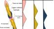
Identifying geochemical halos is critical in locating ore deposits and detecting deeper anomalies. This study presents an approach that combines unsupervised random forests and clustering large applications algorithms to identify intricate patterns in a borehole set of 29 elements data in a suspected gold mineralization area in Iran. The raw geochemical data goes through a log-ratio transformation, followed by staged factor analysis to identify ten main elements. The proposed methodology separated the ten main elements into three distinct halos. The clustering process was validated using various statistical parameters to substantiate the approach’s effectiveness in handling data outliers. The Sequential Indicator Simulation method was used as a geostatistical tool to perform conditional simulation of front, near-ore, and tail halos. Multivariate modeling revealed that the primary halos exhibit a specific spatial pattern encompassing the ore deposit, reinforcing the possibility of a more profound anomaly. The three-dimensional (3D) results obtained from this investigation were subsequently compared with existing geological reports and a comparative method (K-means). This comparison revealed the successful detection of the near-ore halo within the subsurface, extending from the Earth’s surface to a depth of 200 m. Existing geological reports and databases confirm that this halo is strongly associated with the oxide zone.
期刊介绍:
The aim of this international peer-reviewed journal of the Society for Mining, Metallurgy & Exploration (SME) is to provide a broad-based forum for the exchange of real-world and theoretical knowledge from academia, government and industry that is pertinent to mining, mineral/metallurgical processing, exploration and other fields served by the Society.
The journal publishes high-quality original research publications, in-depth special review articles, reviews of state-of-the-art and innovative technologies and industry methodologies, communications of work of topical and emerging interest, and other works that enhance understanding on both the fundamental and practical levels.
 求助内容:
求助内容: 应助结果提醒方式:


