{"title":"Integrating GEE and IWQI for sustainable irrigation: A geospatial water quality assessment","authors":"Uttam Vyas , Dhruvesh Patel , Vinay Vakharia , Keval H. Jodhani","doi":"10.1016/j.gsd.2024.101332","DOIUrl":null,"url":null,"abstract":"<div><p>The surface and sub-surface water quality is one of the decisive parameters for sustainable agriculture and water resources management. Deteriorating water quality impacts the irrigation, crop production, and human health. Therefore, the present work made an attempt to identify the water suitability for irrigation using the contemporary approach i.e. Irrigation Water Quality Index (IWQI) and Zone mapping using GIS techniques, and demonstrated for case of Wadhwan, Gujarat India. Three indices i.e., NDVI, NDWI, and LSWI were mapped using Landsat satellite imagery, whereas, Watermask index was mapped using Sentinel II satellite imagery for the assessment of the availability of water in different forms. The IWQI has applied to categorize the water quality as severe, high, moderate, low, and no restriction. The IWQI in the study area ranges from 6.4 to 62.5. The overall the water quality of study area shows that the 13.64 % of the region in severe restriction range, 56.82% in high restriction range, and 29.54% in moderate restriction range, which is in alarming for farmers and policy makers. The GIS zoning map effectively visualized the spatial distribution of IWQI, helping decision-makers to identify severity zones. Furthermore, the Piper diagram analysis has been performed, which shows that the water quality of the study area falls under mixed Ca<sup>2+</sup>-Mg<sup>2+</sup>-Cl<sup>-</sup>, mixed Ca<sup>2+</sup>-Na<sup>+</sup>-HCO<sub>3</sub><sup>-</sup>, and Na-HCO<sub>3</sub> types. The results revealed that major areas are in moderate to severe restriction zones, lying under deteriorated water quality, and need immediate attention for improvement before use. The IWQI advances SDG 2 (Zero Hunger) by optimizing water quality for crop production and SDG 6 (Clean Water and Sanitation) by ensuring sustainable water resource management, while indirectly supporting SDG 15 (Life on Land) through improved soil health and land management practices.</p></div>","PeriodicalId":37879,"journal":{"name":"Groundwater for Sustainable Development","volume":"27 ","pages":"Article 101332"},"PeriodicalIF":4.9000,"publicationDate":"2024-09-05","publicationTypes":"Journal Article","fieldsOfStudy":null,"isOpenAccess":false,"openAccessPdf":"","citationCount":"0","resultStr":null,"platform":"Semanticscholar","paperid":null,"PeriodicalName":"Groundwater for Sustainable Development","FirstCategoryId":"1085","ListUrlMain":"https://www.sciencedirect.com/science/article/pii/S2352801X24002558","RegionNum":0,"RegionCategory":null,"ArticlePicture":[],"TitleCN":null,"AbstractTextCN":null,"PMCID":null,"EPubDate":"","PubModel":"","JCR":"Q2","JCRName":"ENGINEERING, ENVIRONMENTAL","Score":null,"Total":0}
引用次数: 0
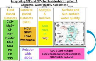
Abstract
The surface and sub-surface water quality is one of the decisive parameters for sustainable agriculture and water resources management. Deteriorating water quality impacts the irrigation, crop production, and human health. Therefore, the present work made an attempt to identify the water suitability for irrigation using the contemporary approach i.e. Irrigation Water Quality Index (IWQI) and Zone mapping using GIS techniques, and demonstrated for case of Wadhwan, Gujarat India. Three indices i.e., NDVI, NDWI, and LSWI were mapped using Landsat satellite imagery, whereas, Watermask index was mapped using Sentinel II satellite imagery for the assessment of the availability of water in different forms. The IWQI has applied to categorize the water quality as severe, high, moderate, low, and no restriction. The IWQI in the study area ranges from 6.4 to 62.5. The overall the water quality of study area shows that the 13.64 % of the region in severe restriction range, 56.82% in high restriction range, and 29.54% in moderate restriction range, which is in alarming for farmers and policy makers. The GIS zoning map effectively visualized the spatial distribution of IWQI, helping decision-makers to identify severity zones. Furthermore, the Piper diagram analysis has been performed, which shows that the water quality of the study area falls under mixed Ca2+-Mg2+-Cl-, mixed Ca2+-Na+-HCO3-, and Na-HCO3 types. The results revealed that major areas are in moderate to severe restriction zones, lying under deteriorated water quality, and need immediate attention for improvement before use. The IWQI advances SDG 2 (Zero Hunger) by optimizing water quality for crop production and SDG 6 (Clean Water and Sanitation) by ensuring sustainable water resource management, while indirectly supporting SDG 15 (Life on Land) through improved soil health and land management practices.
期刊介绍:
Groundwater for Sustainable Development is directed to different stakeholders and professionals, including government and non-governmental organizations, international funding agencies, universities, public water institutions, public health and other public/private sector professionals, and other relevant institutions. It is aimed at professionals, academics and students in the fields of disciplines such as: groundwater and its connection to surface hydrology and environment, soil sciences, engineering, ecology, microbiology, atmospheric sciences, analytical chemistry, hydro-engineering, water technology, environmental ethics, economics, public health, policy, as well as social sciences, legal disciplines, or any other area connected with water issues. The objectives of this journal are to facilitate: • The improvement of effective and sustainable management of water resources across the globe. • The improvement of human access to groundwater resources in adequate quantity and good quality. • The meeting of the increasing demand for drinking and irrigation water needed for food security to contribute to a social and economically sound human development. • The creation of a global inter- and multidisciplinary platform and forum to improve our understanding of groundwater resources and to advocate their effective and sustainable management and protection against contamination. • Interdisciplinary information exchange and to stimulate scientific research in the fields of groundwater related sciences and social and health sciences required to achieve the United Nations Millennium Development Goals for sustainable development.

 求助内容:
求助内容: 应助结果提醒方式:


