Andres Felipe Suárez-Castro, Orlando Acevedo-Charry, Luis Hernando Romero Jiménez, Elkin A. Noguera-Urbano, Fernando Ayerbe-Quiñones, Natalia Ocampo-Peñuela
{"title":"Integrating multiple data sources to develop range and area of habitat maps tailored for local contexts","authors":"Andres Felipe Suárez-Castro, Orlando Acevedo-Charry, Luis Hernando Romero Jiménez, Elkin A. Noguera-Urbano, Fernando Ayerbe-Quiñones, Natalia Ocampo-Peñuela","doi":"10.1111/ddi.13917","DOIUrl":null,"url":null,"abstract":"<div>\n \n \n <section>\n \n <h3> Aim</h3>\n \n <p>Global species distribution maps tend to be limited to a reduced number of species or are too coarse to inform ecological research and conservation actions at local scales. We developed a workflow to generate species range and area of habitat (AOH) maps tailored to local contexts based on expert information, community science observations and an ecoregion approach. We also developed a workflow to increase transparency in range maps and map the areas of uncertainty at the species and community levels using community science data.</p>\n </section>\n \n <section>\n \n <h3> Location</h3>\n \n <p>North-Western South America.</p>\n </section>\n \n <section>\n \n <h3> Methods</h3>\n \n <p>We combined expert knowledge, community science observations, a new map of ecoregions for Colombia and national maps of land cover to produce species range and AOH maps for 94% of the terrestrial resident birds of Colombia (1633 species). We used community science records to validate the range maps and produce a species-specific layer of uncertainty by calculating the distance between pixels classified as habitat and species occurrence points.</p>\n </section>\n \n <section>\n \n <h3> Results</h3>\n \n <p>Compared to previous efforts, the new maps have higher species coverage and produced better validation scores for more than 50% of the species analysed. In addition, the produced maps also show macroecological patterns that follow natural boundaries, significantly improving the arbitrary patterns observed in previous mapping efforts. Uncertainty maps illustrate the spatial resolution and the extent at which these maps can be used with the highest confidence and highlight poorly surveyed areas that require extensive sampling.</p>\n </section>\n \n <section>\n \n <h3> Main Conclusions</h3>\n \n <p>Combining information from expert sources, field observations and broad macroecological patterns is key to improve AOH maps that are fitted to local applications. Our uncertainty analysis can also guide concerted national efforts to survey specific localities. Our workflow can be used in multiple regions, countries and for other taxa, and we expect that it will improve local estimates of biogeographical and species diversity patterns.</p>\n </section>\n </div>","PeriodicalId":51018,"journal":{"name":"Diversity and Distributions","volume":"30 10","pages":""},"PeriodicalIF":4.6000,"publicationDate":"2024-08-15","publicationTypes":"Journal Article","fieldsOfStudy":null,"isOpenAccess":false,"openAccessPdf":"https://onlinelibrary.wiley.com/doi/epdf/10.1111/ddi.13917","citationCount":"0","resultStr":null,"platform":"Semanticscholar","paperid":null,"PeriodicalName":"Diversity and Distributions","FirstCategoryId":"93","ListUrlMain":"https://onlinelibrary.wiley.com/doi/10.1111/ddi.13917","RegionNum":2,"RegionCategory":"环境科学与生态学","ArticlePicture":[],"TitleCN":null,"AbstractTextCN":null,"PMCID":null,"EPubDate":"","PubModel":"","JCR":"Q1","JCRName":"BIODIVERSITY CONSERVATION","Score":null,"Total":0}
引用次数: 0
Abstract
Aim
Global species distribution maps tend to be limited to a reduced number of species or are too coarse to inform ecological research and conservation actions at local scales. We developed a workflow to generate species range and area of habitat (AOH) maps tailored to local contexts based on expert information, community science observations and an ecoregion approach. We also developed a workflow to increase transparency in range maps and map the areas of uncertainty at the species and community levels using community science data.
Location
North-Western South America.
Methods
We combined expert knowledge, community science observations, a new map of ecoregions for Colombia and national maps of land cover to produce species range and AOH maps for 94% of the terrestrial resident birds of Colombia (1633 species). We used community science records to validate the range maps and produce a species-specific layer of uncertainty by calculating the distance between pixels classified as habitat and species occurrence points.
Results
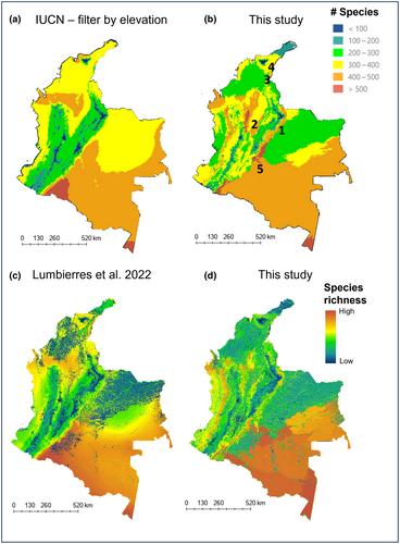
Compared to previous efforts, the new maps have higher species coverage and produced better validation scores for more than 50% of the species analysed. In addition, the produced maps also show macroecological patterns that follow natural boundaries, significantly improving the arbitrary patterns observed in previous mapping efforts. Uncertainty maps illustrate the spatial resolution and the extent at which these maps can be used with the highest confidence and highlight poorly surveyed areas that require extensive sampling.
Main Conclusions
Combining information from expert sources, field observations and broad macroecological patterns is key to improve AOH maps that are fitted to local applications. Our uncertainty analysis can also guide concerted national efforts to survey specific localities. Our workflow can be used in multiple regions, countries and for other taxa, and we expect that it will improve local estimates of biogeographical and species diversity patterns.
期刊介绍:
Diversity and Distributions is a journal of conservation biogeography. We publish papers that deal with the application of biogeographical principles, theories, and analyses (being those concerned with the distributional dynamics of taxa and assemblages) to problems concerning the conservation of biodiversity. We no longer consider papers the sole aim of which is to describe or analyze patterns of biodiversity or to elucidate processes that generate biodiversity.