{"title":"Spatial-Spectrum Two-Branch Model Based on a Superpixel Graph Convolutional Network and 1DCNN for Geochemical Anomaly Identification","authors":"Ying Xu, Renguang Zuo","doi":"10.1007/s11004-024-10158-1","DOIUrl":null,"url":null,"abstract":"<p>In recent years, numerous countries have initiated geochemical survey projects, highlighting the importance of identifying geochemical anomalies for the discovery of potential mineral deposits. In addition, anthropogenic activity, missing or inaccurate data, and overburden can lead to local enrichment or deficiency of elements, resulting in false or weak geochemical anomalies. Simultaneously considering spatial and spectrum information in the data can eliminate spectrum differences caused by the data inaccuracy and enhance weak mineralization anomalies. Therefore, introducing spatial-spectrum models is beneficial for leveraging the strengths of both approaches. This study proposes a two-branch fusion network for extracting spatial-spectrum features from a geochemical survey data cube. The spectrum branch consists of a one-dimensional convolutional neural network (1DCNN) that can be utilized to extract geochemical spectrum information within a single pixel, covering major and trace geochemical elements and accounting for both positive and negative geochemical anomalies. The spatial branch is a superpixel graph convolutional network (SGCN), which is composed of internal and external graph convolutions. The SGCN not only can extract spatial relationships between neighboring pixels and even pixels at a long distance, but also takes into account the anisotropy of mineralization. Furthermore, spatial information can smooth out false geochemical anomalies caused by inaccurate or missing data. A case study was conducted to identify mineralization-related geochemical anomalies and validate the proposed hybrid deep learning model in northwestern Hubei Province, China. Experiments have shown that (1) superpixel segmentation is an effective tool for geochemical anomalies identification, (2) the incorporation of spectrum- and spatial-based methods contributes to the model’s ability to discern anomalies and backgrounds within the geochemical data cube, improving its accuracy in anomaly detection, and (3) the identified anomalous areas provide clues for future mineralization searches.</p>","PeriodicalId":51117,"journal":{"name":"Mathematical Geosciences","volume":"101 1","pages":""},"PeriodicalIF":3.6000,"publicationDate":"2024-09-11","publicationTypes":"Journal Article","fieldsOfStudy":null,"isOpenAccess":false,"openAccessPdf":"","citationCount":"0","resultStr":null,"platform":"Semanticscholar","paperid":null,"PeriodicalName":"Mathematical Geosciences","FirstCategoryId":"89","ListUrlMain":"https://doi.org/10.1007/s11004-024-10158-1","RegionNum":3,"RegionCategory":"地球科学","ArticlePicture":[],"TitleCN":null,"AbstractTextCN":null,"PMCID":null,"EPubDate":"","PubModel":"","JCR":"Q2","JCRName":"GEOSCIENCES, MULTIDISCIPLINARY","Score":null,"Total":0}
引用次数: 0
Abstract
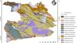
In recent years, numerous countries have initiated geochemical survey projects, highlighting the importance of identifying geochemical anomalies for the discovery of potential mineral deposits. In addition, anthropogenic activity, missing or inaccurate data, and overburden can lead to local enrichment or deficiency of elements, resulting in false or weak geochemical anomalies. Simultaneously considering spatial and spectrum information in the data can eliminate spectrum differences caused by the data inaccuracy and enhance weak mineralization anomalies. Therefore, introducing spatial-spectrum models is beneficial for leveraging the strengths of both approaches. This study proposes a two-branch fusion network for extracting spatial-spectrum features from a geochemical survey data cube. The spectrum branch consists of a one-dimensional convolutional neural network (1DCNN) that can be utilized to extract geochemical spectrum information within a single pixel, covering major and trace geochemical elements and accounting for both positive and negative geochemical anomalies. The spatial branch is a superpixel graph convolutional network (SGCN), which is composed of internal and external graph convolutions. The SGCN not only can extract spatial relationships between neighboring pixels and even pixels at a long distance, but also takes into account the anisotropy of mineralization. Furthermore, spatial information can smooth out false geochemical anomalies caused by inaccurate or missing data. A case study was conducted to identify mineralization-related geochemical anomalies and validate the proposed hybrid deep learning model in northwestern Hubei Province, China. Experiments have shown that (1) superpixel segmentation is an effective tool for geochemical anomalies identification, (2) the incorporation of spectrum- and spatial-based methods contributes to the model’s ability to discern anomalies and backgrounds within the geochemical data cube, improving its accuracy in anomaly detection, and (3) the identified anomalous areas provide clues for future mineralization searches.
期刊介绍:
Mathematical Geosciences (formerly Mathematical Geology) publishes original, high-quality, interdisciplinary papers in geomathematics focusing on quantitative methods and studies of the Earth, its natural resources and the environment. This international publication is the official journal of the IAMG. Mathematical Geosciences is an essential reference for researchers and practitioners of geomathematics who develop and apply quantitative models to earth science and geo-engineering problems.
 求助内容:
求助内容: 应助结果提醒方式:


