Mio-Pliocene paleo-course of Indus River in Upper Sutlej-Zhada basin: Implication of tectonic uplift on river piracy and drainage reorganization in SW Tibet and NW Himalaya
Abhishek Kashyap, Anand Kumar Pandey, Mukunda Dev Behera
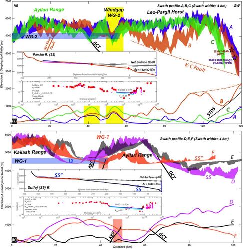
{"title":"Mio-Pliocene paleo-course of Indus River in Upper Sutlej-Zhada basin: Implication of tectonic uplift on river piracy and drainage reorganization in SW Tibet and NW Himalaya","authors":"Abhishek Kashyap, Anand Kumar Pandey, Mukunda Dev Behera","doi":"10.1002/esp.5977","DOIUrl":null,"url":null,"abstract":"<p>We analysed the elevated low-relief relict landscapes in the transient Upper Satluj-Zhada basin and the adjoining region in the tectonically active north-western (NW) Himalaya–south-western (SW) Tibetan orogen to understand the evolution of the regional landscape and drainage system under the influence of the Karakoram Fault-Leo-Pargil Horst system. This elevated low relief landscape represents the Mio-Pliocene establishment of a new river network, which testimonies the present Sutlej River, which has been experiencing a transient surface uplift-incision regime since (~4–1 Ma) with a local base level at the confluence of the Sutlej and Spiti River. The Miocene exhumation of the Ayilari Range and Leo-Pargil Horst across the Karakoram fault (KF) system led to headward erosion, which abandoned the Paleo-Sutlej-Indus drainage system, which in turn caused drainage reversal along Qusum detachment (QD) and produced southward migration of the Paleo-Sutlej River towards the mountain front. Our results indicate that the Upper Indus River has significantly lower χ-ranges at higher elevations as compared with the adjacent Upper Sutlej River at lower elevations, which corresponds with a river piracy model that incorporates area gain-loss feedback. The Upper Sutlej River in the Zhada basin is characterized by a comparable series of coplanar slope-break knickpoints at ~4000–4500 m elevation, and their adjoining divides are in a state of disequilibrium as a consequence of the very high rapid incision across the Leo Pargil Horst, which drives the regional gradation process. The headward-eroding Upper Indus River captured the proto-Sutlej due to a base-level change of >~1500 m, which significantly impacted the regional growth pattern and tectonics. The Mio-Pliocene sedimentation pattern of the Upper Sutlej-Zhada basin in the SW Tibet–NW Himalaya reflects this regional drainage capture, tectonic uplift and paleo-drainage reorganization. The present finding has wider implications for the Mio-Pliocene reorganization of drainage systems and the possible linkage of the Upper Indus River with the Paleo-Sutlej over the Zhada basin.</p>","PeriodicalId":11408,"journal":{"name":"Earth Surface Processes and Landforms","volume":"49 13","pages":"4428-4443"},"PeriodicalIF":2.8000,"publicationDate":"2024-09-07","publicationTypes":"Journal Article","fieldsOfStudy":null,"isOpenAccess":false,"openAccessPdf":"https://onlinelibrary.wiley.com/doi/epdf/10.1002/esp.5977","citationCount":"0","resultStr":null,"platform":"Semanticscholar","paperid":null,"PeriodicalName":"Earth Surface Processes and Landforms","FirstCategoryId":"89","ListUrlMain":"https://onlinelibrary.wiley.com/doi/10.1002/esp.5977","RegionNum":3,"RegionCategory":"地球科学","ArticlePicture":[],"TitleCN":null,"AbstractTextCN":null,"PMCID":null,"EPubDate":"","PubModel":"","JCR":"Q2","JCRName":"GEOGRAPHY, PHYSICAL","Score":null,"Total":0}
引用次数: 0
Abstract
We analysed the elevated low-relief relict landscapes in the transient Upper Satluj-Zhada basin and the adjoining region in the tectonically active north-western (NW) Himalaya–south-western (SW) Tibetan orogen to understand the evolution of the regional landscape and drainage system under the influence of the Karakoram Fault-Leo-Pargil Horst system. This elevated low relief landscape represents the Mio-Pliocene establishment of a new river network, which testimonies the present Sutlej River, which has been experiencing a transient surface uplift-incision regime since (~4–1 Ma) with a local base level at the confluence of the Sutlej and Spiti River. The Miocene exhumation of the Ayilari Range and Leo-Pargil Horst across the Karakoram fault (KF) system led to headward erosion, which abandoned the Paleo-Sutlej-Indus drainage system, which in turn caused drainage reversal along Qusum detachment (QD) and produced southward migration of the Paleo-Sutlej River towards the mountain front. Our results indicate that the Upper Indus River has significantly lower χ-ranges at higher elevations as compared with the adjacent Upper Sutlej River at lower elevations, which corresponds with a river piracy model that incorporates area gain-loss feedback. The Upper Sutlej River in the Zhada basin is characterized by a comparable series of coplanar slope-break knickpoints at ~4000–4500 m elevation, and their adjoining divides are in a state of disequilibrium as a consequence of the very high rapid incision across the Leo Pargil Horst, which drives the regional gradation process. The headward-eroding Upper Indus River captured the proto-Sutlej due to a base-level change of >~1500 m, which significantly impacted the regional growth pattern and tectonics. The Mio-Pliocene sedimentation pattern of the Upper Sutlej-Zhada basin in the SW Tibet–NW Himalaya reflects this regional drainage capture, tectonic uplift and paleo-drainage reorganization. The present finding has wider implications for the Mio-Pliocene reorganization of drainage systems and the possible linkage of the Upper Indus River with the Paleo-Sutlej over the Zhada basin.
期刊介绍:
Earth Surface Processes and Landforms is an interdisciplinary international journal concerned with:
the interactions between surface processes and landforms and landscapes;
that lead to physical, chemical and biological changes; and which in turn create;
current landscapes and the geological record of past landscapes.
Its focus is core to both physical geographical and geological communities, and also the wider geosciences

 求助内容:
求助内容: 应助结果提醒方式:


