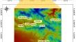
{"title":"Evaluation of SWAT Model in Runoff Simulation Using Rainfall and Temperature Derived From Satellite Images","authors":"Mohammd Tavosi, Mehdi Vafakhah, Vahid Moosavi","doi":"10.1007/s40996-024-01597-1","DOIUrl":null,"url":null,"abstract":"<p>Accurate simulation of hydrological processes in watersheds is of great importance. The accuracy of rainfall and temperature data plays a crucial role as effective inputs in hydrological models, such as the Soil and Water Assessment Tool (SWAT) model, significantly impacting the accuracy of the model outputs. This is despite the insufficiency of climatological stations in watersheds. Therefore, the present study aimed to evaluate the SWAT model in runoff simulation using rainfall and temperature from ground stations in comparison with the data derived from satellite images. To do this, rainfall and surface temperature data were extracted the number of 14,608 images from three-hour Tropical Rainfall Measuring Mission (TRMM) product and the number of 1826 images from Moderate Resolution Imaging Spectroradiometer (MODIS) products in Taleghan dam watershed, from 2009 to 2015. Minimum and maximum daily air temperatures were estimated from Land Surface Temperature (LST) data through multiple regression analysis. The Soil and Water Assessment Tool (SWAT) model was executed under four different scenarios: the first involved using rainfall and temperature data exclusively from ground stations, in the second, rainfall was sourced from TRMM images and temperature from ground stations, the third strategy combined ground station rainfall data with MODIS temperature data, and the fourth strategy utilized satellite-derived data for both rainfall and temperature inputs. Findings from the study revealed that the SWAT model demonstrated the most accurate runoff simulations when incorporating satellite-derived data. Specifically, the Nash–Sutcliffe Efficiency (NSE) values were 0.67 and 0.83 for daily and monthly time scales, respectively, indicating superior performance compared to using solely ground station data. When ground station data alone were employed, the NSE values were slightly lower at 0.62 and 0.7 for daily and monthly time scales, respectively. These results underscore the effectiveness of utilizing satellite-derived data as inputs for hydrological models, particularly in regions where there is a scarcity of observational data. This suggests that satellite data can play a crucial role in enhancing the accuracy and reliability of hydrological modeling, offering valuable insights for improved water resource management in data-constrained environments.</p>","PeriodicalId":14550,"journal":{"name":"Iranian Journal of Science and Technology, Transactions of Civil Engineering","volume":"86 1","pages":""},"PeriodicalIF":1.7000,"publicationDate":"2024-09-02","publicationTypes":"Journal Article","fieldsOfStudy":null,"isOpenAccess":false,"openAccessPdf":"","citationCount":"0","resultStr":null,"platform":"Semanticscholar","paperid":null,"PeriodicalName":"Iranian Journal of Science and Technology, Transactions of Civil Engineering","FirstCategoryId":"5","ListUrlMain":"https://doi.org/10.1007/s40996-024-01597-1","RegionNum":4,"RegionCategory":"工程技术","ArticlePicture":[],"TitleCN":null,"AbstractTextCN":null,"PMCID":null,"EPubDate":"","PubModel":"","JCR":"Q3","JCRName":"ENGINEERING, CIVIL","Score":null,"Total":0}
引用次数: 0
Abstract
Accurate simulation of hydrological processes in watersheds is of great importance. The accuracy of rainfall and temperature data plays a crucial role as effective inputs in hydrological models, such as the Soil and Water Assessment Tool (SWAT) model, significantly impacting the accuracy of the model outputs. This is despite the insufficiency of climatological stations in watersheds. Therefore, the present study aimed to evaluate the SWAT model in runoff simulation using rainfall and temperature from ground stations in comparison with the data derived from satellite images. To do this, rainfall and surface temperature data were extracted the number of 14,608 images from three-hour Tropical Rainfall Measuring Mission (TRMM) product and the number of 1826 images from Moderate Resolution Imaging Spectroradiometer (MODIS) products in Taleghan dam watershed, from 2009 to 2015. Minimum and maximum daily air temperatures were estimated from Land Surface Temperature (LST) data through multiple regression analysis. The Soil and Water Assessment Tool (SWAT) model was executed under four different scenarios: the first involved using rainfall and temperature data exclusively from ground stations, in the second, rainfall was sourced from TRMM images and temperature from ground stations, the third strategy combined ground station rainfall data with MODIS temperature data, and the fourth strategy utilized satellite-derived data for both rainfall and temperature inputs. Findings from the study revealed that the SWAT model demonstrated the most accurate runoff simulations when incorporating satellite-derived data. Specifically, the Nash–Sutcliffe Efficiency (NSE) values were 0.67 and 0.83 for daily and monthly time scales, respectively, indicating superior performance compared to using solely ground station data. When ground station data alone were employed, the NSE values were slightly lower at 0.62 and 0.7 for daily and monthly time scales, respectively. These results underscore the effectiveness of utilizing satellite-derived data as inputs for hydrological models, particularly in regions where there is a scarcity of observational data. This suggests that satellite data can play a crucial role in enhancing the accuracy and reliability of hydrological modeling, offering valuable insights for improved water resource management in data-constrained environments.
期刊介绍:
The aim of the Iranian Journal of Science and Technology is to foster the growth of scientific research among Iranian engineers and scientists and to provide a medium by means of which the fruits of these researches may be brought to the attention of the world’s civil Engineering communities. This transaction focuses on all aspects of Civil Engineering
and will accept the original research contributions (previously unpublished) from all areas of established engineering disciplines. The papers may be theoretical, experimental or both. The journal publishes original papers within the broad field of civil engineering which include, but are not limited to, the following:
-Structural engineering-
Earthquake engineering-
Concrete engineering-
Construction management-
Steel structures-
Engineering mechanics-
Water resources engineering-
Hydraulic engineering-
Hydraulic structures-
Environmental engineering-
Soil mechanics-
Foundation engineering-
Geotechnical engineering-
Transportation engineering-
Surveying and geomatics.
 求助内容:
求助内容: 应助结果提醒方式:


