Soil erosion susceptibility prediction using ensemble hybrid models with multicriteria decision-making analysis: Case study of the Medjerda basin, northern Africa
IF 3.7
2区 环境科学与生态学
Q2 ENVIRONMENTAL SCIENCES
引用次数: 0
Abstract
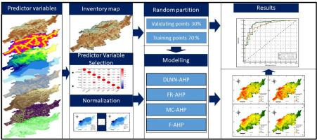
Soil erosion is considered one of the most prevalent natural hazards in semiarid regions, leading to the instability of ecosystems and human life. The main purpose of this research was to investigate and analyze soil erosion susceptibility maps in the Medjerda basin in northern Africa. This study utilizes four ensemble models based on the analytical hierarchy process (AHP) multicriteria decision-making analysis, namely, deep learning neural network AHP (DLNN-AHP), frequency ratio AHP (FR-AHP), Monte Carlo AHP (MC-AHP), and fuzzy AHP (F-AHP). Eight predictor variables were considered as inputs to the model, namely, the slope degree, digital elevation model (DEM), topographic wetness index (TWI), distance to river (DFR), distance to road (DFRD), normalized difference vegetation index (NDVI), rainfall erosivity (R), factor and soil erodibility factor (K). Soil erosion inventory maps were developed from field surveys and satellite images. The dataset was randomly divided into 70% for training and 30% for testing. The performances of the utilized models were compared using a receiver operating characteristic (ROC) curve. The results highlighted that all the models utilized exhibited good performance, with DLNN-AHP (93.1%) exhibiting slight superiority, followed by FR-AHP (90.9%), F-AHP (88.9%), and MC-AHP (88.5%). Among the influencing factors, the distance to the river and rainfall erosivity had the most significant impacts on the incidence of soil erosion. Moreover, the current findings revealed that 38.3% of the study area is extremely highly susceptible to soil erosion. The results of this study can aid in developing decision-support tools for planners and managers aiming to mitigate the adverse effects of soil erosion.

利用集合混合模型和多标准决策分析进行土壤侵蚀易感性预测:北非梅杰达盆地案例研究
水土流失被认为是半干旱地区最普遍的自然灾害之一,会导致生态系统和人类生活的不稳定。本研究的主要目的是调查和分析非洲北部梅杰达盆地的土壤侵蚀易感性地图。本研究采用了四种基于分析层次过程(AHP)多标准决策分析的集合模型,即深度学习神经网络 AHP(DLNN-AHP)、频率比 AHP(FR-AHP)、蒙特卡罗 AHP(MC-AHP)和模糊 AHP(F-AHP)。八个预测变量被视为模型的输入变量,即坡度、数字高程模型(DEM)、地形湿润指数(TWI)、河流距离(DFR)、道路距离(DFRD)、归一化植被差异指数(NDVI)、降雨侵蚀率()、因子和土壤可侵蚀性因子()。土壤侵蚀清单图是根据实地调查和卫星图像绘制的。数据集随机分为 70% 用于训练,30% 用于测试。使用接收器工作特征曲线(ROC)对所使用模型的性能进行了比较。结果表明,所有使用的模型都表现出良好的性能,其中 DLNN-AHP(93.1%)略胜一筹,其次是 FR-AHP(90.9%)、F-AHP(88.9%)和 MC-AHP(88.5%)。在影响因素中,河流距离和降雨侵蚀性对水土流失发生率的影响最为显著。此外,目前的研究结果表明,38.3% 的研究区域极易发生水土流失。这项研究的结果有助于为规划者和管理者开发决策支持工具,以减轻水土流失的不利影响。
本文章由计算机程序翻译,如有差异,请以英文原文为准。
求助全文
约1分钟内获得全文
求助全文
来源期刊
CiteScore
6.90
自引率
5.60%
发文量
88
审稿时长
74 days
期刊介绍:
International Journal of Sediment Research, the Official Journal of The International Research and Training Center on Erosion and Sedimentation and The World Association for Sedimentation and Erosion Research, publishes scientific and technical papers on all aspects of erosion and sedimentation interpreted in its widest sense.
The subject matter is to include not only the mechanics of sediment transport and fluvial processes, but also what is related to geography, geomorphology, soil erosion, watershed management, sedimentology, environmental and ecological impacts of sedimentation, social and economical effects of sedimentation and its assessment, etc. Special attention is paid to engineering problems related to sedimentation and erosion.

 求助内容:
求助内容: 应助结果提醒方式:


