Imaging Spectroscopy-Based Estimation of Aboveground Biomass in Louisiana's Coastal Wetlands: Toward Consistent Spectroscopic Retrievals Across Atmospheric States
Daniel Jensen, David R. Thompson, Marc Simard, Elena Solohin, Edward Castañeda-Moya
{"title":"Imaging Spectroscopy-Based Estimation of Aboveground Biomass in Louisiana's Coastal Wetlands: Toward Consistent Spectroscopic Retrievals Across Atmospheric States","authors":"Daniel Jensen, David R. Thompson, Marc Simard, Elena Solohin, Edward Castañeda-Moya","doi":"10.1029/2024JG008112","DOIUrl":null,"url":null,"abstract":"<p>Developing accurate landscape-scale aboveground biomass (AGB) maps is critical to understanding coastal deltaic wetland resilience, as AGB influences stability and elevation dynamics in herbaceous wetlands. Here we used AVIRIS-NG imaging spectrometer (or “hyperspectral”) data from NASA's 2021 Delta-X mission in coastal Louisiana to map seasonal changes in herbaceous AGB across two deltaic basins with contrasting sediment delivery and hydrologic regimes: the Atchafalaya (active) and Terrebonne (inactive). We assessed the impact of atmospheric effects on our retrievals, as high water vapor content in August 2021 caused significant noise in the 880–1,000 and 1,080–1,200 nm near-infrared (NIR) wavelengths. We hypothesized that correcting these wavelengths with our conditional Gaussian interpolation algorithm would improve AGB estimates due to their association with plant canopy water content. We empirically assessed the performance of the corrected spectra on AGB estimates using Partial Least Squares Regression (PLSR), finding that the corrected NIR bands attained high variable importance and reduced estimation errors. Our Random Forest regression approach based on the corrected spectra attained equivalent error metrics via leave-one-out-cross-validation as the PLSR models (<i>R</i><sup>2</sup> = 0.43, mean absolute error = 257.3 g/m<sup>2</sup>) while greatly improving the AGB maps' visual quality, having better captured variability while reducing noise and discontinuities in AGB estimates across flightlines. The maps show differing seasonal growth, with the Atchafalaya and Terrebonne Basins' AGB increasing from means of 4.3–9.4 and 4.6–8.9 Mg/ha, respectively. We demonstrated that imaging spectroscopy can be applied to assess herbaceous biomass stocks, growth patterns, and resilience in coastal ecosystems.</p>","PeriodicalId":16003,"journal":{"name":"Journal of Geophysical Research: Biogeosciences","volume":"129 9","pages":""},"PeriodicalIF":3.7000,"publicationDate":"2024-09-09","publicationTypes":"Journal Article","fieldsOfStudy":null,"isOpenAccess":false,"openAccessPdf":"https://onlinelibrary.wiley.com/doi/epdf/10.1029/2024JG008112","citationCount":"0","resultStr":null,"platform":"Semanticscholar","paperid":null,"PeriodicalName":"Journal of Geophysical Research: Biogeosciences","FirstCategoryId":"93","ListUrlMain":"https://onlinelibrary.wiley.com/doi/10.1029/2024JG008112","RegionNum":3,"RegionCategory":"环境科学与生态学","ArticlePicture":[],"TitleCN":null,"AbstractTextCN":null,"PMCID":null,"EPubDate":"","PubModel":"","JCR":"Q2","JCRName":"ENVIRONMENTAL SCIENCES","Score":null,"Total":0}
引用次数: 0
Abstract
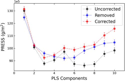
Developing accurate landscape-scale aboveground biomass (AGB) maps is critical to understanding coastal deltaic wetland resilience, as AGB influences stability and elevation dynamics in herbaceous wetlands. Here we used AVIRIS-NG imaging spectrometer (or “hyperspectral”) data from NASA's 2021 Delta-X mission in coastal Louisiana to map seasonal changes in herbaceous AGB across two deltaic basins with contrasting sediment delivery and hydrologic regimes: the Atchafalaya (active) and Terrebonne (inactive). We assessed the impact of atmospheric effects on our retrievals, as high water vapor content in August 2021 caused significant noise in the 880–1,000 and 1,080–1,200 nm near-infrared (NIR) wavelengths. We hypothesized that correcting these wavelengths with our conditional Gaussian interpolation algorithm would improve AGB estimates due to their association with plant canopy water content. We empirically assessed the performance of the corrected spectra on AGB estimates using Partial Least Squares Regression (PLSR), finding that the corrected NIR bands attained high variable importance and reduced estimation errors. Our Random Forest regression approach based on the corrected spectra attained equivalent error metrics via leave-one-out-cross-validation as the PLSR models (R2 = 0.43, mean absolute error = 257.3 g/m2) while greatly improving the AGB maps' visual quality, having better captured variability while reducing noise and discontinuities in AGB estimates across flightlines. The maps show differing seasonal growth, with the Atchafalaya and Terrebonne Basins' AGB increasing from means of 4.3–9.4 and 4.6–8.9 Mg/ha, respectively. We demonstrated that imaging spectroscopy can be applied to assess herbaceous biomass stocks, growth patterns, and resilience in coastal ecosystems.
期刊介绍:
JGR-Biogeosciences focuses on biogeosciences of the Earth system in the past, present, and future and the extension of this research to planetary studies. The emerging field of biogeosciences spans the intellectual interface between biology and the geosciences and attempts to understand the functions of the Earth system across multiple spatial and temporal scales. Studies in biogeosciences may use multiple lines of evidence drawn from diverse fields to gain a holistic understanding of terrestrial, freshwater, and marine ecosystems and extreme environments. Specific topics within the scope of the section include process-based theoretical, experimental, and field studies of biogeochemistry, biogeophysics, atmosphere-, land-, and ocean-ecosystem interactions, biomineralization, life in extreme environments, astrobiology, microbial processes, geomicrobiology, and evolutionary geobiology
 求助内容:
求助内容: 应助结果提醒方式:


