M. S. Bauck, J. I. Faleide, H. Fossen, M. Hassaan, A. Braathen
{"title":"Late Palaeozoic structural evolution of the Patch Bank Ridge and Utsira High, northern North Sea","authors":"M. S. Bauck, J. I. Faleide, H. Fossen, M. Hassaan, A. Braathen","doi":"10.1111/bre.12890","DOIUrl":null,"url":null,"abstract":"<p>This study focuses on the Late Palaeozoic development of the area east of Utsira High in the North Sea, where the stratigraphic section below the late Permian Rotliegend Group is undrilled. We use regional 3D seismic data to study structuring, sediment distribution and geomorphology across the Patch Bank Ridge and Utsira High in the North Sea. The results show that the Stord Basin and the bounding Utsira East fault initially developed during the Late Palaeozoic extension, probably during the Devonian, and that the Utsira Shear Zone controlled the location of Late Palaeozoic depocentres. The Patch Bank Ridge is an uplifted part of the Stord Basin where we identify Late Palaeozoic growth strata along the southern and northern flanks, indicating a similar timing of the structural evolution in this area. Two key wells, in the Sele High and Ling Depression, are used to relate a Late Palaeozoic isopach map with regional structuring, surface tilt and basement morphology to the enigmatic parts of the Late Palaeozoic basin system. Our results supplement regional models for the Late Palaeozoic basin development, we suggest that the deeply eroded Devonian half-grabens preserved on the Utsira High formed parts of an extensive basin system that show stratigraphic expansion towards their bounding faults. The Top Basement surface at these highs offers several distinct geomorphologies that evolved during three periods of exposure, expressed as (i) a tilted and rugose landscape, (ii) distinct drainage networks and (iii) peneplain surfaces. Cover sediments place these landscapes to the (i) Devonian, (ii) Carboniferous/Permian/Triassic and (iii) Late Triassic periods.</p>","PeriodicalId":8712,"journal":{"name":"Basin Research","volume":"36 5","pages":""},"PeriodicalIF":2.6000,"publicationDate":"2024-08-30","publicationTypes":"Journal Article","fieldsOfStudy":null,"isOpenAccess":false,"openAccessPdf":"https://onlinelibrary.wiley.com/doi/epdf/10.1111/bre.12890","citationCount":"0","resultStr":null,"platform":"Semanticscholar","paperid":null,"PeriodicalName":"Basin Research","FirstCategoryId":"89","ListUrlMain":"https://onlinelibrary.wiley.com/doi/10.1111/bre.12890","RegionNum":2,"RegionCategory":"地球科学","ArticlePicture":[],"TitleCN":null,"AbstractTextCN":null,"PMCID":null,"EPubDate":"","PubModel":"","JCR":"Q2","JCRName":"GEOSCIENCES, MULTIDISCIPLINARY","Score":null,"Total":0}
引用次数: 0
Abstract
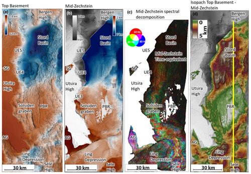
This study focuses on the Late Palaeozoic development of the area east of Utsira High in the North Sea, where the stratigraphic section below the late Permian Rotliegend Group is undrilled. We use regional 3D seismic data to study structuring, sediment distribution and geomorphology across the Patch Bank Ridge and Utsira High in the North Sea. The results show that the Stord Basin and the bounding Utsira East fault initially developed during the Late Palaeozoic extension, probably during the Devonian, and that the Utsira Shear Zone controlled the location of Late Palaeozoic depocentres. The Patch Bank Ridge is an uplifted part of the Stord Basin where we identify Late Palaeozoic growth strata along the southern and northern flanks, indicating a similar timing of the structural evolution in this area. Two key wells, in the Sele High and Ling Depression, are used to relate a Late Palaeozoic isopach map with regional structuring, surface tilt and basement morphology to the enigmatic parts of the Late Palaeozoic basin system. Our results supplement regional models for the Late Palaeozoic basin development, we suggest that the deeply eroded Devonian half-grabens preserved on the Utsira High formed parts of an extensive basin system that show stratigraphic expansion towards their bounding faults. The Top Basement surface at these highs offers several distinct geomorphologies that evolved during three periods of exposure, expressed as (i) a tilted and rugose landscape, (ii) distinct drainage networks and (iii) peneplain surfaces. Cover sediments place these landscapes to the (i) Devonian, (ii) Carboniferous/Permian/Triassic and (iii) Late Triassic periods.
期刊介绍:
Basin Research is an international journal which aims to publish original, high impact research papers on sedimentary basin systems. We view integrated, interdisciplinary research as being essential for the advancement of the subject area; therefore, we do not seek manuscripts focused purely on sedimentology, structural geology, or geophysics that have a natural home in specialist journals. Rather, we seek manuscripts that treat sedimentary basins as multi-component systems that require a multi-faceted approach to advance our understanding of their development. During deposition and subsidence we are concerned with large-scale geodynamic processes, heat flow, fluid flow, strain distribution, seismic and sequence stratigraphy, modelling, burial and inversion histories. In addition, we view the development of the source area, in terms of drainage networks, climate, erosion, denudation and sediment routing systems as vital to sedimentary basin systems. The underpinning requirement is that a contribution should be of interest to earth scientists of more than one discipline.
 求助内容:
求助内容: 应助结果提醒方式:


