Lucas Albanese Valore, Tor Oftedal Sømme, Stefano Patruno, Cécile Robin, François Guillocheau, Christian Haug Eide
{"title":"Palaeogeography and 3D variability of a dynamically uplifted shelf: Observations from seismic stratigraphy of the Palaeocene East Shetland Platform","authors":"Lucas Albanese Valore, Tor Oftedal Sømme, Stefano Patruno, Cécile Robin, François Guillocheau, Christian Haug Eide","doi":"10.1111/bre.12895","DOIUrl":null,"url":null,"abstract":"<p>In the Palaeocene North Sea, pulses in turbidite fan deposition and shelfal progradation have been correlated with episodes of regional uplift caused by a precursor of the Icelandic Plume. In the East Shetland Platform, the specific impacts of dynamic uplift on the regional palaeogeographic evolution are less understood. Using new, high-resolution 3D seismic data from an underexplored proximal area, we investigate the palaeogeography of the East Shetland Platform in terms of the extent and timing of erosion versus deposition, focusing on how these can be used to reconstruct changes in relative sea-level along strike. Using a combination of well data, clinoform-based seismic stratigraphy and seismic attribute analysis of >60,000 km<sup>2</sup> of 3D data, we have obtained palaeogeographic maps of multiple Palaeocene to Early Eocene units, with high temporal resolution for the Late Palaeocene–Early Eocene Moray Group. This includes six unconformity-bounded units marked by prograding clinoforms of the Dornoch Formation, which are covered by backstepping sequences of the Beauly Member (Balder Formation). Temporal and spatial changes in the distribution of downdip depocentres and updip unconformities indicate strong lateral variability in patterns of shelf accommodation/erosion and local sediment supply. This results from a complex interplay among laterally uneven relative sea-level fall, inherited topography, time-varied sediment entry point distribution and along-shore sediment transport regimes. Unconformities and palaeogeographic maps suggest a first-order control on erosion and sediment distribution promoted by the transiently and differentially uplifted topography of Shetland, which is characterized by an anomalous erosive history in the Bressay High, in the centre of our study area, where the Lower Dornoch Formation has been eroded and marked fluvial incision is observed. Ultimately, results indicate shorter-wavelength and shorter-period variations in uplift than what is typically assumed for dynamic topography, perhaps as a result of additional modulation by lithospheric structures or influence of previous rift-related faults.</p>","PeriodicalId":8712,"journal":{"name":"Basin Research","volume":"36 5","pages":""},"PeriodicalIF":2.6000,"publicationDate":"2024-08-28","publicationTypes":"Journal Article","fieldsOfStudy":null,"isOpenAccess":false,"openAccessPdf":"https://onlinelibrary.wiley.com/doi/epdf/10.1111/bre.12895","citationCount":"0","resultStr":null,"platform":"Semanticscholar","paperid":null,"PeriodicalName":"Basin Research","FirstCategoryId":"89","ListUrlMain":"https://onlinelibrary.wiley.com/doi/10.1111/bre.12895","RegionNum":2,"RegionCategory":"地球科学","ArticlePicture":[],"TitleCN":null,"AbstractTextCN":null,"PMCID":null,"EPubDate":"","PubModel":"","JCR":"Q2","JCRName":"GEOSCIENCES, MULTIDISCIPLINARY","Score":null,"Total":0}
引用次数: 0
Abstract
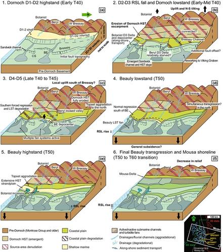
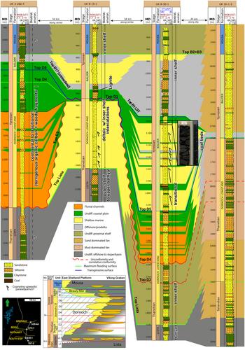
In the Palaeocene North Sea, pulses in turbidite fan deposition and shelfal progradation have been correlated with episodes of regional uplift caused by a precursor of the Icelandic Plume. In the East Shetland Platform, the specific impacts of dynamic uplift on the regional palaeogeographic evolution are less understood. Using new, high-resolution 3D seismic data from an underexplored proximal area, we investigate the palaeogeography of the East Shetland Platform in terms of the extent and timing of erosion versus deposition, focusing on how these can be used to reconstruct changes in relative sea-level along strike. Using a combination of well data, clinoform-based seismic stratigraphy and seismic attribute analysis of >60,000 km2 of 3D data, we have obtained palaeogeographic maps of multiple Palaeocene to Early Eocene units, with high temporal resolution for the Late Palaeocene–Early Eocene Moray Group. This includes six unconformity-bounded units marked by prograding clinoforms of the Dornoch Formation, which are covered by backstepping sequences of the Beauly Member (Balder Formation). Temporal and spatial changes in the distribution of downdip depocentres and updip unconformities indicate strong lateral variability in patterns of shelf accommodation/erosion and local sediment supply. This results from a complex interplay among laterally uneven relative sea-level fall, inherited topography, time-varied sediment entry point distribution and along-shore sediment transport regimes. Unconformities and palaeogeographic maps suggest a first-order control on erosion and sediment distribution promoted by the transiently and differentially uplifted topography of Shetland, which is characterized by an anomalous erosive history in the Bressay High, in the centre of our study area, where the Lower Dornoch Formation has been eroded and marked fluvial incision is observed. Ultimately, results indicate shorter-wavelength and shorter-period variations in uplift than what is typically assumed for dynamic topography, perhaps as a result of additional modulation by lithospheric structures or influence of previous rift-related faults.
期刊介绍:
Basin Research is an international journal which aims to publish original, high impact research papers on sedimentary basin systems. We view integrated, interdisciplinary research as being essential for the advancement of the subject area; therefore, we do not seek manuscripts focused purely on sedimentology, structural geology, or geophysics that have a natural home in specialist journals. Rather, we seek manuscripts that treat sedimentary basins as multi-component systems that require a multi-faceted approach to advance our understanding of their development. During deposition and subsidence we are concerned with large-scale geodynamic processes, heat flow, fluid flow, strain distribution, seismic and sequence stratigraphy, modelling, burial and inversion histories. In addition, we view the development of the source area, in terms of drainage networks, climate, erosion, denudation and sediment routing systems as vital to sedimentary basin systems. The underpinning requirement is that a contribution should be of interest to earth scientists of more than one discipline.
 求助内容:
求助内容: 应助结果提醒方式:


