{"title":"Anisotropic effect of shear zone on groundwater potentiality in crystalline hard rock terrain","authors":"","doi":"10.1016/j.gsd.2024.101320","DOIUrl":null,"url":null,"abstract":"<div><p>Assessment of potential groundwater recharge sites and sustainable water resource management in semi-arid crystalline rock terrain is a challenging task. Globally, analysis of remote sensing satellite imagery data for delineation of groundwater potential zones over sheared crystalline hard rock terrains has been fairly successful. But there is no existing study present at our disposal which discusses the factors controlling the inconsistent groundwater potentiality that exits along the shear zones. This study attempts to analyse the major geological factors controlling the irregular groundwater potentiality of shear zones within older crystalline rock terrain. Therefore, the study area selected for this analysis is the Purulia district of West Bengal, NE India, composed mostly of Precambrian metamorphic rocks i.e., quartzite, granite gneisses, porphyroclastic granite-gneiss, quartzo-feldspathic-granite-gneiss, mylonitic granites, quartz-biotite-granite gneiss, quartzites, carbonatites and phyllites. Satellite imagery study of IRS-P6 LISS IV standard FCC image reveals the presence of two bifurcating shear zones namely North Purulia Shear Zone (NPSZ) and South Purulia Shear Zone (SPSZ) over the study area. Careful analysis of rock structure, different lithotypes, soil thickness, electrical resistivity tomography data and water table data with an emphasis on high water table fluctuation, shows a strong spatial relation between the potentially good groundwater recharge zones and the branching/confluence sites of shear zones present in the study area. The study constructs an attempt to demonstrate the relationship between shear zone conjunctions and significant groundwater recharge sites in Precambrian crystalline fractured-rock aquifer system.</p></div>","PeriodicalId":37879,"journal":{"name":"Groundwater for Sustainable Development","volume":null,"pages":null},"PeriodicalIF":4.9000,"publicationDate":"2024-08-22","publicationTypes":"Journal Article","fieldsOfStudy":null,"isOpenAccess":false,"openAccessPdf":"","citationCount":"0","resultStr":null,"platform":"Semanticscholar","paperid":null,"PeriodicalName":"Groundwater for Sustainable Development","FirstCategoryId":"1085","ListUrlMain":"https://www.sciencedirect.com/science/article/pii/S2352801X24002431","RegionNum":0,"RegionCategory":null,"ArticlePicture":[],"TitleCN":null,"AbstractTextCN":null,"PMCID":null,"EPubDate":"","PubModel":"","JCR":"Q2","JCRName":"ENGINEERING, ENVIRONMENTAL","Score":null,"Total":0}
引用次数: 0
Abstract
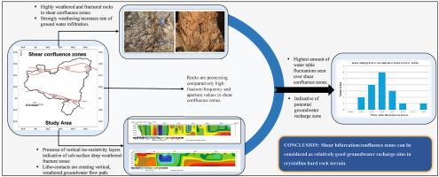
Assessment of potential groundwater recharge sites and sustainable water resource management in semi-arid crystalline rock terrain is a challenging task. Globally, analysis of remote sensing satellite imagery data for delineation of groundwater potential zones over sheared crystalline hard rock terrains has been fairly successful. But there is no existing study present at our disposal which discusses the factors controlling the inconsistent groundwater potentiality that exits along the shear zones. This study attempts to analyse the major geological factors controlling the irregular groundwater potentiality of shear zones within older crystalline rock terrain. Therefore, the study area selected for this analysis is the Purulia district of West Bengal, NE India, composed mostly of Precambrian metamorphic rocks i.e., quartzite, granite gneisses, porphyroclastic granite-gneiss, quartzo-feldspathic-granite-gneiss, mylonitic granites, quartz-biotite-granite gneiss, quartzites, carbonatites and phyllites. Satellite imagery study of IRS-P6 LISS IV standard FCC image reveals the presence of two bifurcating shear zones namely North Purulia Shear Zone (NPSZ) and South Purulia Shear Zone (SPSZ) over the study area. Careful analysis of rock structure, different lithotypes, soil thickness, electrical resistivity tomography data and water table data with an emphasis on high water table fluctuation, shows a strong spatial relation between the potentially good groundwater recharge zones and the branching/confluence sites of shear zones present in the study area. The study constructs an attempt to demonstrate the relationship between shear zone conjunctions and significant groundwater recharge sites in Precambrian crystalline fractured-rock aquifer system.
期刊介绍:
Groundwater for Sustainable Development is directed to different stakeholders and professionals, including government and non-governmental organizations, international funding agencies, universities, public water institutions, public health and other public/private sector professionals, and other relevant institutions. It is aimed at professionals, academics and students in the fields of disciplines such as: groundwater and its connection to surface hydrology and environment, soil sciences, engineering, ecology, microbiology, atmospheric sciences, analytical chemistry, hydro-engineering, water technology, environmental ethics, economics, public health, policy, as well as social sciences, legal disciplines, or any other area connected with water issues. The objectives of this journal are to facilitate: • The improvement of effective and sustainable management of water resources across the globe. • The improvement of human access to groundwater resources in adequate quantity and good quality. • The meeting of the increasing demand for drinking and irrigation water needed for food security to contribute to a social and economically sound human development. • The creation of a global inter- and multidisciplinary platform and forum to improve our understanding of groundwater resources and to advocate their effective and sustainable management and protection against contamination. • Interdisciplinary information exchange and to stimulate scientific research in the fields of groundwater related sciences and social and health sciences required to achieve the United Nations Millennium Development Goals for sustainable development.

 求助内容:
求助内容: 应助结果提醒方式:


