Glacial to periglacial transition at the end of the last ice age in the subtropical semiarid Andes

IF 3.1 2区 地球科学 Q2 GEOGRAPHY, PHYSICAL
Juan-Luis García , Javiera Carraha , Hans Fernández-Navarro , Samuel U. Nussbaumer , Francia Pérez , Alan J. Hidy , Isabelle Gärtner-Roer , Wilfried Haeberli
{"title":"Glacial to periglacial transition at the end of the last ice age in the subtropical semiarid Andes","authors":"Juan-Luis García ,&nbsp;Javiera Carraha ,&nbsp;Hans Fernández-Navarro ,&nbsp;Samuel U. Nussbaumer ,&nbsp;Francia Pérez ,&nbsp;Alan J. Hidy ,&nbsp;Isabelle Gärtner-Roer ,&nbsp;Wilfried Haeberli","doi":"10.1016/j.geomorph.2024.109379","DOIUrl":null,"url":null,"abstract":"<div><p>Atmospheric warming and circulation reorganization at the end of the last ice age represent the most important climate change of the last 100,000 years and provide an opportunity to uncover how the southern subtropics cryosphere responded to strong changes in the global climate system. Extensive mapping and chronologic records on cryogenic landforms to better understand the association and interactions between glaciers and viscous creep of ice-rich permafrost landforms (rock glaciers) are widely missing in the region. In this paper, we reconstruct the geomorphic imprint of the Last Glacial Maximum (LGM) and the Termination I in the high Andes of the Río Limarí Basin (30–31°S) in the subtropical semiarid Andes of Chile. 74 new <sup>10</sup>Be surface exposure dating ages constrain the timing of glaciation, deglaciation, and glacial to periglacial transition. Glacial advances occurred first by 41.2 ± 0.6 – 35.0 ± 0.5 ka during Marine Isotope Stage 3, but probably earlier also; then, a second advance occurred during the global LGM between 24.2 ± 0.4 and 18.6 ± 0.2 ka. Deglaciation by 17.6 ± 0.2 ka left extensive hummocky moraines on the main valleys. Characteristic patterns of furrows and ridges typical of rock glaciers and solifluction superimposed on the LGM hummocky moraine indicate ice-rich permafrost in glacial deposits likely between 15.5 ± 0.3 and 13.6 ± 0.3 ka. We propose that moraines deposited by LGM debris-covered glaciers served as a niche for strong seasonal frost and permafrost creep, which substantially modified the original landforms. Our results contribute to a better understanding of major transformations in an ice-rich high mountain area of the southern hemisphere where the interplay of temperature and precipitation changes drove glacial to periglacial transitions.</p></div>","PeriodicalId":55115,"journal":{"name":"Geomorphology","volume":"465 ","pages":"Article 109379"},"PeriodicalIF":3.1000,"publicationDate":"2024-08-16","publicationTypes":"Journal Article","fieldsOfStudy":null,"isOpenAccess":false,"openAccessPdf":"","citationCount":"0","resultStr":null,"platform":"Semanticscholar","paperid":null,"PeriodicalName":"Geomorphology","FirstCategoryId":"89","ListUrlMain":"https://www.sciencedirect.com/science/article/pii/S0169555X24003295","RegionNum":2,"RegionCategory":"地球科学","ArticlePicture":[],"TitleCN":null,"AbstractTextCN":null,"PMCID":null,"EPubDate":"","PubModel":"","JCR":"Q2","JCRName":"GEOGRAPHY, PHYSICAL","Score":null,"Total":0}
引用次数: 0

Abstract

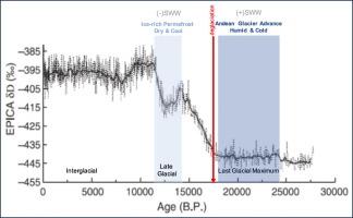
Atmospheric warming and circulation reorganization at the end of the last ice age represent the most important climate change of the last 100,000 years and provide an opportunity to uncover how the southern subtropics cryosphere responded to strong changes in the global climate system. Extensive mapping and chronologic records on cryogenic landforms to better understand the association and interactions between glaciers and viscous creep of ice-rich permafrost landforms (rock glaciers) are widely missing in the region. In this paper, we reconstruct the geomorphic imprint of the Last Glacial Maximum (LGM) and the Termination I in the high Andes of the Río Limarí Basin (30–31°S) in the subtropical semiarid Andes of Chile. 74 new 10Be surface exposure dating ages constrain the timing of glaciation, deglaciation, and glacial to periglacial transition. Glacial advances occurred first by 41.2 ± 0.6 – 35.0 ± 0.5 ka during Marine Isotope Stage 3, but probably earlier also; then, a second advance occurred during the global LGM between 24.2 ± 0.4 and 18.6 ± 0.2 ka. Deglaciation by 17.6 ± 0.2 ka left extensive hummocky moraines on the main valleys. Characteristic patterns of furrows and ridges typical of rock glaciers and solifluction superimposed on the LGM hummocky moraine indicate ice-rich permafrost in glacial deposits likely between 15.5 ± 0.3 and 13.6 ± 0.3 ka. We propose that moraines deposited by LGM debris-covered glaciers served as a niche for strong seasonal frost and permafrost creep, which substantially modified the original landforms. Our results contribute to a better understanding of major transformations in an ice-rich high mountain area of the southern hemisphere where the interplay of temperature and precipitation changes drove glacial to periglacial transitions.
Abstract Image

亚热带半干旱地区安第斯山脉最后一个冰期末期冰川向围冰期的过渡
上一个冰期结束时的大气变暖和环流重组是过去 10 万年来最重要的气候变化,为揭示南亚热带冰冻圈如何应对全球气候系统的强烈变化提供了机会。为了更好地了解冰川与富冰永久冻土地貌(岩石冰川)粘性蠕变之间的关联和相互作用,该地区普遍缺乏对低温地貌的广泛测绘和年代学记录。在本文中,我们重建了智利亚热带半干旱安第斯山脉 Río Limarí 盆地(南纬 30-31 度)安第斯高山地区末次冰川极盛时期(LGM)和终止期 I 的地貌印记。74 个新的 10Be 地表暴露年代测定确定了冰川形成、冰川消退和冰川向围冰期过渡的时间。在海洋同位素第三阶段(41.2±0.6-35.0±0.5 ka),冰川首先出现,但也可能更早;然后,在全球远古时期(24.2±0.4-18.6±0.2 ka),冰川第二次出现。17.6±0.2ka的脱冰期在主要山谷上留下了大面积的沼泽冰碛。岩冰川和溶蚀作用的典型沟槽和山脊的特征模式叠加在元古代的沼泽状冰碛上,表明冰川沉积物中的富冰永久冻土可能发生在 15.5 ± 0.3 ka 到 13.6 ± 0.3 ka 之间。我们认为,LGM碎屑覆盖冰川沉积的冰碛为强烈的季节性霜冻和永久冻土蠕变提供了场所,从而极大地改变了原始地貌。我们的研究结果有助于更好地理解南半球富冰高山地区的重大变化,在那里,温度和降水变化的相互作用推动了冰川向围冰期的过渡。
本文章由计算机程序翻译,如有差异,请以英文原文为准。
求助全文
约1分钟内获得全文 求助全文
来源期刊
Geomorphology
Geomorphology 地学-地球科学综合
CiteScore
8.00
自引率
10.30%
发文量
309
审稿时长
3.4 months
期刊介绍: Our journal''s scope includes geomorphic themes of: tectonics and regional structure; glacial processes and landforms; fluvial sequences, Quaternary environmental change and dating; fluvial processes and landforms; mass movement, slopes and periglacial processes; hillslopes and soil erosion; weathering, karst and soils; aeolian processes and landforms, coastal dunes and arid environments; coastal and marine processes, estuaries and lakes; modelling, theoretical and quantitative geomorphology; DEM, GIS and remote sensing methods and applications; hazards, applied and planetary geomorphology; and volcanics.
×
引用
GB/T 7714-2015
复制
MLA
复制
APA
复制
导出至
BibTeX EndNote RefMan NoteFirst NoteExpress
×
提示
您的信息不完整,为了账户安全,请先补充。
现在去补充
×
提示
您因"违规操作"
具体请查看互助需知
我知道了
×
提示
确定
请完成安全验证×
copy
已复制链接
快去分享给好友吧!
我知道了
右上角分享
点击右上角分享
0
联系我们:info@booksci.cn Book学术提供免费学术资源搜索服务,方便国内外学者检索中英文文献。致力于提供最便捷和优质的服务体验。 Copyright © 2023 布克学术 All rights reserved.
京ICP备2023020795号-1
ghs 京公网安备 11010802042870号
Book学术文献互助
Book学术文献互助群
群 号:481959085
Book学术官方微信