Combined use of physically based hydrological model and empirical models to improve parameterisation of erosion processes in a flash flood prone catchment
{"title":"Combined use of physically based hydrological model and empirical models to improve parameterisation of erosion processes in a flash flood prone catchment","authors":"Atiyeh Hosseinzadeh, Hélène Roux, Ludovic Cassan, Audrey Douinot","doi":"10.1002/esp.5946","DOIUrl":null,"url":null,"abstract":"<p>This study assesses the effectiveness of a distributed physically based hydrological model (MARINE) to investigate erosion estimation during flash floods compared with other widely used empirical models derived from the Universal Soil Loss Equation (USLE) like Revised Universal Soil Loss Equation (RUSLE) and Modified Universal Soil Loss Equation (MUSLE). It is carried out on a small catchment in south-eastern France, the Claduègne catchment. To compare the erosion volumes simulated by the three models, MARINE, MUSLE and RUSLE, a sensitivity analysis on the model parameters is carried out. According to physics-based simulations, flood events fall into two categories: those dominated by raindrop erosion and those dominated by shear stress erosion. The results show that the erosion simulated by the three methods are comparable, except for events dominated by raindrop erosion suggesting that further research is needed to improve raindrop erosion within MARINE. Simulations from the MARINE model provide access to the spatio-temporal variability of erosion dynamics during the event and can also be used to produce erosion/deposition maps, which are useful for environmental decision-makers and planners in identifying areas at risk from erosion and deposition hazards.</p>","PeriodicalId":11408,"journal":{"name":"Earth Surface Processes and Landforms","volume":"49 12","pages":"3934-3948"},"PeriodicalIF":2.8000,"publicationDate":"2024-08-05","publicationTypes":"Journal Article","fieldsOfStudy":null,"isOpenAccess":false,"openAccessPdf":"https://onlinelibrary.wiley.com/doi/epdf/10.1002/esp.5946","citationCount":"0","resultStr":null,"platform":"Semanticscholar","paperid":null,"PeriodicalName":"Earth Surface Processes and Landforms","FirstCategoryId":"89","ListUrlMain":"https://onlinelibrary.wiley.com/doi/10.1002/esp.5946","RegionNum":3,"RegionCategory":"地球科学","ArticlePicture":[],"TitleCN":null,"AbstractTextCN":null,"PMCID":null,"EPubDate":"","PubModel":"","JCR":"Q2","JCRName":"GEOGRAPHY, PHYSICAL","Score":null,"Total":0}
引用次数: 0
Abstract
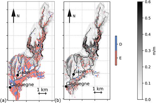
This study assesses the effectiveness of a distributed physically based hydrological model (MARINE) to investigate erosion estimation during flash floods compared with other widely used empirical models derived from the Universal Soil Loss Equation (USLE) like Revised Universal Soil Loss Equation (RUSLE) and Modified Universal Soil Loss Equation (MUSLE). It is carried out on a small catchment in south-eastern France, the Claduègne catchment. To compare the erosion volumes simulated by the three models, MARINE, MUSLE and RUSLE, a sensitivity analysis on the model parameters is carried out. According to physics-based simulations, flood events fall into two categories: those dominated by raindrop erosion and those dominated by shear stress erosion. The results show that the erosion simulated by the three methods are comparable, except for events dominated by raindrop erosion suggesting that further research is needed to improve raindrop erosion within MARINE. Simulations from the MARINE model provide access to the spatio-temporal variability of erosion dynamics during the event and can also be used to produce erosion/deposition maps, which are useful for environmental decision-makers and planners in identifying areas at risk from erosion and deposition hazards.
期刊介绍:
Earth Surface Processes and Landforms is an interdisciplinary international journal concerned with:
the interactions between surface processes and landforms and landscapes;
that lead to physical, chemical and biological changes; and which in turn create;
current landscapes and the geological record of past landscapes.
Its focus is core to both physical geographical and geological communities, and also the wider geosciences

 求助内容:
求助内容: 应助结果提醒方式:


