{"title":"Gully erosion susceptibility assessment using three machine learning models in the black soil region of Northeast China","authors":"","doi":"10.1016/j.catena.2024.108275","DOIUrl":null,"url":null,"abstract":"<div><p>Gully erosion has significantly increased and severely threatened agricultural production and food security, especially in the black soil region of Northeast China. The present study is set out to select the importance factors in gully erosion occurrence and compare similarities and differences in importance factors among watersheds, validate the applicability of the transformer model, and analyze the spatial distribution characteristic of gully erosion susceptibility maps (GESMs) and relationship between sloping farmland and gully erosion susceptibility area. 25 geo-environmental factors (GEFs) affecting the occurrence of gully erosion were identified through various data resource platforms and Arcgis10.2, and gully inventory maps were generated from remote sensing image interpretation and field survey. The mathematical relationships between GEFs and erosion gullies were established using random forest (RF), convolutional neural network (CNN), and transformer models after multi-collinearity test. The 10-fold cross-validation and 8 indicators were used to comprehensively compare the model performances. Results showed that the 10 factors played a key role in gully erosion occurrence in the black soil region of Northeast China which were convergence index (CI), distance from river, rainfall, terrain ruggedness index (TRI), normalized difference vegetation index (NDVI), topographic wetness index (TWI), elevation, distance from road, drainage density, and slope respectively. Except TWI, elevation, and slope, other 7 importance factors are shared among watersheds but with different degrees of importance. The transformer model has better applicability. According to the GESMs, the low susceptibility areas were still dominant and the occurrence of gully erosion was mostly in the very high susceptibility area. Our results demonstrate that the very high susceptibility area was related to the sloping farmland closely and exceeding 75% of very high susceptibility areas were located on sloping farmland.</p></div>","PeriodicalId":9801,"journal":{"name":"Catena","volume":null,"pages":null},"PeriodicalIF":5.4000,"publicationDate":"2024-08-07","publicationTypes":"Journal Article","fieldsOfStudy":null,"isOpenAccess":false,"openAccessPdf":"","citationCount":"0","resultStr":null,"platform":"Semanticscholar","paperid":null,"PeriodicalName":"Catena","FirstCategoryId":"97","ListUrlMain":"https://www.sciencedirect.com/science/article/pii/S0341816224004727","RegionNum":1,"RegionCategory":"农林科学","ArticlePicture":[],"TitleCN":null,"AbstractTextCN":null,"PMCID":null,"EPubDate":"","PubModel":"","JCR":"Q1","JCRName":"GEOSCIENCES, MULTIDISCIPLINARY","Score":null,"Total":0}
引用次数: 0
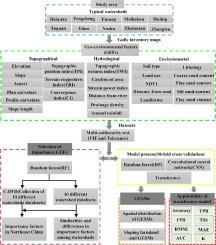
Abstract
Gully erosion has significantly increased and severely threatened agricultural production and food security, especially in the black soil region of Northeast China. The present study is set out to select the importance factors in gully erosion occurrence and compare similarities and differences in importance factors among watersheds, validate the applicability of the transformer model, and analyze the spatial distribution characteristic of gully erosion susceptibility maps (GESMs) and relationship between sloping farmland and gully erosion susceptibility area. 25 geo-environmental factors (GEFs) affecting the occurrence of gully erosion were identified through various data resource platforms and Arcgis10.2, and gully inventory maps were generated from remote sensing image interpretation and field survey. The mathematical relationships between GEFs and erosion gullies were established using random forest (RF), convolutional neural network (CNN), and transformer models after multi-collinearity test. The 10-fold cross-validation and 8 indicators were used to comprehensively compare the model performances. Results showed that the 10 factors played a key role in gully erosion occurrence in the black soil region of Northeast China which were convergence index (CI), distance from river, rainfall, terrain ruggedness index (TRI), normalized difference vegetation index (NDVI), topographic wetness index (TWI), elevation, distance from road, drainage density, and slope respectively. Except TWI, elevation, and slope, other 7 importance factors are shared among watersheds but with different degrees of importance. The transformer model has better applicability. According to the GESMs, the low susceptibility areas were still dominant and the occurrence of gully erosion was mostly in the very high susceptibility area. Our results demonstrate that the very high susceptibility area was related to the sloping farmland closely and exceeding 75% of very high susceptibility areas were located on sloping farmland.
期刊介绍:
Catena publishes papers describing original field and laboratory investigations and reviews on geoecology and landscape evolution with emphasis on interdisciplinary aspects of soil science, hydrology and geomorphology. It aims to disseminate new knowledge and foster better understanding of the physical environment, of evolutionary sequences that have resulted in past and current landscapes, and of the natural processes that are likely to determine the fate of our terrestrial environment.
Papers within any one of the above topics are welcome provided they are of sufficiently wide interest and relevance.

 求助内容:
求助内容: 应助结果提醒方式:


