Chongzheng Ye , Huinan Ma , Xianwen Li , Shengli Guo , Xiaorong Wei , Yaxian Hu
{"title":"Lateral CO2 emission from eroded scarps and terrace sidewalls: A non-negligible but long-ignored carbon source","authors":"Chongzheng Ye , Huinan Ma , Xianwen Li , Shengli Guo , Xiaorong Wei , Yaxian Hu","doi":"10.1016/j.catena.2024.108272","DOIUrl":null,"url":null,"abstract":"<div><p>The “U” or “V” shaped gullies on the Chinese Loess Plateau are highly susceptible to landslides and bank failure. The lateral carbon emissions from the bare scarps (valley banks or gully sidewalls) in theory promise a non-negligible carbon source, but had long been ignored due to their inaccessibility and underrepresentation in orthographic projection. In this study, the all-year-round CO<sub>2</sub> fluxes from the flatland, gully sidewalls and terrace sidewalls were monitored <em>in-situ</em> in a gully-dominated catchment on the Chinese Loess Plateau. The instantaneous responses of CO<sub>2</sub> fluxes to bank failure and drying-rewetting cycles were further examined by manual detachment and rainfall simulation. We observed that: 1) The sidewalls emitted CO<sub>2</sub> in all seasons, from warm rainy summer to freezing dry winter. The average CO<sub>2</sub> emission rates from the sidewalls reached 26% of that from the flatland, even though the soil organic carbon, dissolved organic carbon and soil microbial biomass carbon content of the barren soil on the sidewalls was disproportionally lower as 57%, 44%, and 76% of that on the flatland. 2) The simulation of bank failure and drying-rewetting cycles could rejuvenate the sidewalls and thus enhance the CO<sub>2</sub> emission rates, respectively by 49%, 27%, and collectively by 82%. 3) Based on the digital terrain model developed from the imagery acquired by the unmanned aerial vehicle, the actual exposed area of the study site was 46% larger than its ortho-projected area. This not only challenges the plausibility of conventional orthographic projection to estimate the actual soil surface area in similar regions predominated with eroded scarps and bench terraces, but also highlights the non-negligible contributions from lateral CO<sub>2</sub> emissions to local carbon source strength. The vigorous responses of lateral CO<sub>2</sub> emissions to soil water, temperature and layer detachment further emphasize the vulnerability of bank failure, which may potentially introduce more exposed area and thus trigger more CO<sub>2</sub> fluxes under future climate conditions. Therefore, the lateral CO<sub>2</sub> emissions from steep slopes or eroded scarps should not be ignored but deserve systematic investigations in complex terrains similar to the Chinese Loess Plateau.</p></div>","PeriodicalId":9801,"journal":{"name":"Catena","volume":"245 ","pages":"Article 108272"},"PeriodicalIF":5.7000,"publicationDate":"2024-08-07","publicationTypes":"Journal Article","fieldsOfStudy":null,"isOpenAccess":false,"openAccessPdf":"","citationCount":"0","resultStr":null,"platform":"Semanticscholar","paperid":null,"PeriodicalName":"Catena","FirstCategoryId":"97","ListUrlMain":"https://www.sciencedirect.com/science/article/pii/S0341816224004697","RegionNum":1,"RegionCategory":"农林科学","ArticlePicture":[],"TitleCN":null,"AbstractTextCN":null,"PMCID":null,"EPubDate":"","PubModel":"","JCR":"Q1","JCRName":"GEOSCIENCES, MULTIDISCIPLINARY","Score":null,"Total":0}
引用次数: 0
Abstract
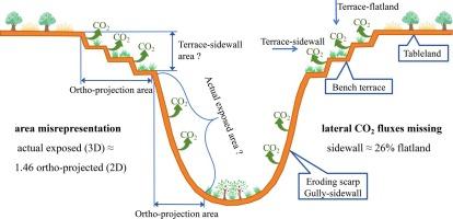
The “U” or “V” shaped gullies on the Chinese Loess Plateau are highly susceptible to landslides and bank failure. The lateral carbon emissions from the bare scarps (valley banks or gully sidewalls) in theory promise a non-negligible carbon source, but had long been ignored due to their inaccessibility and underrepresentation in orthographic projection. In this study, the all-year-round CO2 fluxes from the flatland, gully sidewalls and terrace sidewalls were monitored in-situ in a gully-dominated catchment on the Chinese Loess Plateau. The instantaneous responses of CO2 fluxes to bank failure and drying-rewetting cycles were further examined by manual detachment and rainfall simulation. We observed that: 1) The sidewalls emitted CO2 in all seasons, from warm rainy summer to freezing dry winter. The average CO2 emission rates from the sidewalls reached 26% of that from the flatland, even though the soil organic carbon, dissolved organic carbon and soil microbial biomass carbon content of the barren soil on the sidewalls was disproportionally lower as 57%, 44%, and 76% of that on the flatland. 2) The simulation of bank failure and drying-rewetting cycles could rejuvenate the sidewalls and thus enhance the CO2 emission rates, respectively by 49%, 27%, and collectively by 82%. 3) Based on the digital terrain model developed from the imagery acquired by the unmanned aerial vehicle, the actual exposed area of the study site was 46% larger than its ortho-projected area. This not only challenges the plausibility of conventional orthographic projection to estimate the actual soil surface area in similar regions predominated with eroded scarps and bench terraces, but also highlights the non-negligible contributions from lateral CO2 emissions to local carbon source strength. The vigorous responses of lateral CO2 emissions to soil water, temperature and layer detachment further emphasize the vulnerability of bank failure, which may potentially introduce more exposed area and thus trigger more CO2 fluxes under future climate conditions. Therefore, the lateral CO2 emissions from steep slopes or eroded scarps should not be ignored but deserve systematic investigations in complex terrains similar to the Chinese Loess Plateau.
期刊介绍:
Catena publishes papers describing original field and laboratory investigations and reviews on geoecology and landscape evolution with emphasis on interdisciplinary aspects of soil science, hydrology and geomorphology. It aims to disseminate new knowledge and foster better understanding of the physical environment, of evolutionary sequences that have resulted in past and current landscapes, and of the natural processes that are likely to determine the fate of our terrestrial environment.
Papers within any one of the above topics are welcome provided they are of sufficiently wide interest and relevance.

 求助内容:
求助内容: 应助结果提醒方式:


