Jean L. Dixon, Grace E. Nicholas, Kenneth L. Pierce, David Lageson
{"title":"Morphology, timing, and drivers of post-glacial landslides in the northern Yellowstone region","authors":"Jean L. Dixon, Grace E. Nicholas, Kenneth L. Pierce, David Lageson","doi":"10.1002/esp.5943","DOIUrl":null,"url":null,"abstract":"<p>The withdrawal of glaciers in mountainous systems exposes over-steepened slopes previously sculpted by ice. This debuttressing can directly trigger mass movements or leave slopes susceptible to them by other drivers, including seismogenic shaking and changing climate conditions. These systems may pose hazards long after deglaciation. Here, we investigate the drivers of slope failure for landslides at the northern entrance to Yellowstone National Park, a critical conduit traversed by ~1 million visitors each year. Through field mapping and analyses of LiDAR data, we quantify the spatial and temporal relationships between eight adjacent slides. Stratigraphic relationships and surface roughness analyses suggest initial emplacement 13–11.5 ka, after a significant delay from Deckard Flats glacial retreat (15.1 ± 1.2 ka). Thus, rapid glacial debuttressing was not the direct trigger of slope failure, though the resultant change in stress regime likely had a preparatory influence. We posit that the timing of failure was associated with (1) a period of enhanced moisture and seismicity in the late Pleistocene and (2) altered stress regimes associated with ice retreat. Historical archives and cross-cutting relationships indicate portions of some ancient slides were reactivated; these areas are morphologically distinguishable from other slide surfaces, with mean topographic roughness 2 times that of non-active slides. Stream power analysis and archival records indicate Holocene incision of the Gardner River and human disturbances are largely responsible for modern reactivations. Our findings highlight the importance of combining archival records with stratigraphic, field and remote sensing approaches to understanding landslide timing, risk, and drivers in post-glacial environments. This study also provides a valuable baseline for geomorphic change in the Yellowstone system, where a 2022 flood incised streams, damaged infrastructure and further reactivated landslide slopes.</p>","PeriodicalId":11408,"journal":{"name":"Earth Surface Processes and Landforms","volume":"49 12","pages":"3873-3888"},"PeriodicalIF":2.8000,"publicationDate":"2024-08-08","publicationTypes":"Journal Article","fieldsOfStudy":null,"isOpenAccess":false,"openAccessPdf":"https://onlinelibrary.wiley.com/doi/epdf/10.1002/esp.5943","citationCount":"0","resultStr":null,"platform":"Semanticscholar","paperid":null,"PeriodicalName":"Earth Surface Processes and Landforms","FirstCategoryId":"89","ListUrlMain":"https://onlinelibrary.wiley.com/doi/10.1002/esp.5943","RegionNum":3,"RegionCategory":"地球科学","ArticlePicture":[],"TitleCN":null,"AbstractTextCN":null,"PMCID":null,"EPubDate":"","PubModel":"","JCR":"Q2","JCRName":"GEOGRAPHY, PHYSICAL","Score":null,"Total":0}
引用次数: 0
Abstract
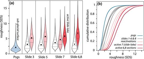
The withdrawal of glaciers in mountainous systems exposes over-steepened slopes previously sculpted by ice. This debuttressing can directly trigger mass movements or leave slopes susceptible to them by other drivers, including seismogenic shaking and changing climate conditions. These systems may pose hazards long after deglaciation. Here, we investigate the drivers of slope failure for landslides at the northern entrance to Yellowstone National Park, a critical conduit traversed by ~1 million visitors each year. Through field mapping and analyses of LiDAR data, we quantify the spatial and temporal relationships between eight adjacent slides. Stratigraphic relationships and surface roughness analyses suggest initial emplacement 13–11.5 ka, after a significant delay from Deckard Flats glacial retreat (15.1 ± 1.2 ka). Thus, rapid glacial debuttressing was not the direct trigger of slope failure, though the resultant change in stress regime likely had a preparatory influence. We posit that the timing of failure was associated with (1) a period of enhanced moisture and seismicity in the late Pleistocene and (2) altered stress regimes associated with ice retreat. Historical archives and cross-cutting relationships indicate portions of some ancient slides were reactivated; these areas are morphologically distinguishable from other slide surfaces, with mean topographic roughness 2 times that of non-active slides. Stream power analysis and archival records indicate Holocene incision of the Gardner River and human disturbances are largely responsible for modern reactivations. Our findings highlight the importance of combining archival records with stratigraphic, field and remote sensing approaches to understanding landslide timing, risk, and drivers in post-glacial environments. This study also provides a valuable baseline for geomorphic change in the Yellowstone system, where a 2022 flood incised streams, damaged infrastructure and further reactivated landslide slopes.
期刊介绍:
Earth Surface Processes and Landforms is an interdisciplinary international journal concerned with:
the interactions between surface processes and landforms and landscapes;
that lead to physical, chemical and biological changes; and which in turn create;
current landscapes and the geological record of past landscapes.
Its focus is core to both physical geographical and geological communities, and also the wider geosciences

 求助内容:
求助内容: 应助结果提醒方式:


