Miguel E. Valencia, Michael C. Sukop, Grace Oldfield, Angela Montoya, Virginia Walsh, Jayantha Obeysekera, Samantha Barquin, Elizabeth Kelly, Katherine Hagemann, Aliza Karim, Oscar F. Guzman
{"title":"Septic Return Flow Pathlines, Endpoints, and Flows Based on the Urban Miami-Dade Groundwater Model","authors":"Miguel E. Valencia, Michael C. Sukop, Grace Oldfield, Angela Montoya, Virginia Walsh, Jayantha Obeysekera, Samantha Barquin, Elizabeth Kelly, Katherine Hagemann, Aliza Karim, Oscar F. Guzman","doi":"10.1111/gwat.13435","DOIUrl":null,"url":null,"abstract":"<p>Miami-Dade County (MDC) has over 112,000 septic systems, some of which are at risk of compromise due to water table rise associated with sea level rise. MDC is surrounded by protected water bodies, including Biscayne Bay, with environmentally sensitive ecosystems and is underlain by highly transmissive karstic limestone. The main objective of the study is to provide first estimates of the locations and magnitudes of septic return flows to discharge endpoints. This is accomplished by leveraging MDC's county-scale surface-groundwater model using pathline analysis to estimate the transport and discharge fate of septic system flows under the complex time history of groundwater flow response to pumping, canal management, storms, and other environmental factors. The model covers an area of 4772 km<sup>2</sup> in Southeast Florida. Outputs from the model were used to create a 30-year (2010 to 2040) simulation of the spatial–temporal pathlines from septic input locations to their termination points, allowing us to map flow paths and the spatial distribution of the septic flow discharge endpoints under the simulated conditions. Most septic return flows were discharged to surface water, primarily canals 52,830 m<sup>3</sup>/d and Biscayne Bay (5696 m<sup>3</sup>/d), and well fields (14,066 m<sup>3</sup>/d). Results allow us to identify “hotspots” to guide water quality sampling efforts and to provide recommendations for septic-to-sewer conversion areas that should provide most benefit by reducing nutrient loading to water bodies.</p>","PeriodicalId":12866,"journal":{"name":"Groundwater","volume":"62 6","pages":"957-971"},"PeriodicalIF":2.0000,"publicationDate":"2024-08-07","publicationTypes":"Journal Article","fieldsOfStudy":null,"isOpenAccess":false,"openAccessPdf":"https://onlinelibrary.wiley.com/doi/epdf/10.1111/gwat.13435","citationCount":"0","resultStr":null,"platform":"Semanticscholar","paperid":null,"PeriodicalName":"Groundwater","FirstCategoryId":"89","ListUrlMain":"https://ngwa.onlinelibrary.wiley.com/doi/10.1111/gwat.13435","RegionNum":4,"RegionCategory":"地球科学","ArticlePicture":[],"TitleCN":null,"AbstractTextCN":null,"PMCID":null,"EPubDate":"","PubModel":"","JCR":"Q3","JCRName":"GEOSCIENCES, MULTIDISCIPLINARY","Score":null,"Total":0}
引用次数: 0
Abstract
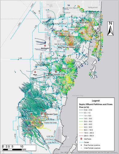
Miami-Dade County (MDC) has over 112,000 septic systems, some of which are at risk of compromise due to water table rise associated with sea level rise. MDC is surrounded by protected water bodies, including Biscayne Bay, with environmentally sensitive ecosystems and is underlain by highly transmissive karstic limestone. The main objective of the study is to provide first estimates of the locations and magnitudes of septic return flows to discharge endpoints. This is accomplished by leveraging MDC's county-scale surface-groundwater model using pathline analysis to estimate the transport and discharge fate of septic system flows under the complex time history of groundwater flow response to pumping, canal management, storms, and other environmental factors. The model covers an area of 4772 km2 in Southeast Florida. Outputs from the model were used to create a 30-year (2010 to 2040) simulation of the spatial–temporal pathlines from septic input locations to their termination points, allowing us to map flow paths and the spatial distribution of the septic flow discharge endpoints under the simulated conditions. Most septic return flows were discharged to surface water, primarily canals 52,830 m3/d and Biscayne Bay (5696 m3/d), and well fields (14,066 m3/d). Results allow us to identify “hotspots” to guide water quality sampling efforts and to provide recommendations for septic-to-sewer conversion areas that should provide most benefit by reducing nutrient loading to water bodies.
期刊介绍:
Ground Water is the leading international journal focused exclusively on ground water. Since 1963, Ground Water has published a dynamic mix of papers on topics related to ground water including ground water flow and well hydraulics, hydrogeochemistry and contaminant hydrogeology, application of geophysics, groundwater management and policy, and history of ground water hydrology. This is the journal you can count on to bring you the practical applications in ground water hydrology.

 求助内容:
求助内容: 应助结果提醒方式:


