Integrating geoinformatics and numerical modelling for landslide back-analysis and forecasting: a proactive mitigation study of the Shiv Bawri landslide
{"title":"Integrating geoinformatics and numerical modelling for landslide back-analysis and forecasting: a proactive mitigation study of the Shiv Bawri landslide","authors":"Avinash Sajwan, G. V. Ramana","doi":"10.1007/s10346-024-02321-w","DOIUrl":null,"url":null,"abstract":"<p>In the monsoon season of 2023, Himachal Pradesh witnessed the catastrophic Shiv Bawri landslide, underscoring the vulnerability of mountainous regions to natural disasters. This study employs advanced geoinformatics and numerical modelling to provide a comprehensive back-analysis and forecasting of landslide dynamics. A detailed methodology encompassing field investigations, drone surveys, and data compilation for rainfall and satellite imagery forms the basis of the analysis. A multi-phase mass flow model and the TRIGRS-derived factors of safety for pre-event and post-event analysis, considering vegetation’s influence through root reinforcement models, are employed. The findings reveal a high correspondence between modelled and actual landslide events, with the models effectively predicting the landslide’s volume, flow height, and velocity. The multi-phase mass flow calculations yield a volume estimate of 4.12 <span>\\(\\times\\)</span> 10<sup>4</sup> m<sup>3</sup> (post-event) and 2.92 <span>\\(\\times\\)</span> 10<sup>4</sup> m<sup>3</sup> (pre-event), with respective validation success rates of 88.99% and 93.9%. The analysis indicates maximum flow height and velocity of 14.2 m and 16.2 m/s for post-event and 12.1 m and 12.6 m/s for pre-event analysis. The study emphasises the necessity of integrating detailed terrain analysis and numerical modelling for effective landslide risk mitigation and preparedness. By providing insights into the complex interplay of natural factors leading to landslides, this research advances the proactive management of landslide risks in susceptible mountainous regions.</p>","PeriodicalId":17938,"journal":{"name":"Landslides","volume":"75 1","pages":""},"PeriodicalIF":7.0000,"publicationDate":"2024-08-03","publicationTypes":"Journal Article","fieldsOfStudy":null,"isOpenAccess":false,"openAccessPdf":"","citationCount":"0","resultStr":null,"platform":"Semanticscholar","paperid":null,"PeriodicalName":"Landslides","FirstCategoryId":"89","ListUrlMain":"https://doi.org/10.1007/s10346-024-02321-w","RegionNum":2,"RegionCategory":"工程技术","ArticlePicture":[],"TitleCN":null,"AbstractTextCN":null,"PMCID":null,"EPubDate":"","PubModel":"","JCR":"Q1","JCRName":"ENGINEERING, GEOLOGICAL","Score":null,"Total":0}
引用次数: 0
Abstract
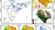
In the monsoon season of 2023, Himachal Pradesh witnessed the catastrophic Shiv Bawri landslide, underscoring the vulnerability of mountainous regions to natural disasters. This study employs advanced geoinformatics and numerical modelling to provide a comprehensive back-analysis and forecasting of landslide dynamics. A detailed methodology encompassing field investigations, drone surveys, and data compilation for rainfall and satellite imagery forms the basis of the analysis. A multi-phase mass flow model and the TRIGRS-derived factors of safety for pre-event and post-event analysis, considering vegetation’s influence through root reinforcement models, are employed. The findings reveal a high correspondence between modelled and actual landslide events, with the models effectively predicting the landslide’s volume, flow height, and velocity. The multi-phase mass flow calculations yield a volume estimate of 4.12 \(\times\) 104 m3 (post-event) and 2.92 \(\times\) 104 m3 (pre-event), with respective validation success rates of 88.99% and 93.9%. The analysis indicates maximum flow height and velocity of 14.2 m and 16.2 m/s for post-event and 12.1 m and 12.6 m/s for pre-event analysis. The study emphasises the necessity of integrating detailed terrain analysis and numerical modelling for effective landslide risk mitigation and preparedness. By providing insights into the complex interplay of natural factors leading to landslides, this research advances the proactive management of landslide risks in susceptible mountainous regions.
期刊介绍:
Landslides are gravitational mass movements of rock, debris or earth. They may occur in conjunction with other major natural disasters such as floods, earthquakes and volcanic eruptions. Expanding urbanization and changing land-use practices have increased the incidence of landslide disasters. Landslides as catastrophic events include human injury, loss of life and economic devastation and are studied as part of the fields of earth, water and engineering sciences. The aim of the journal Landslides is to be the common platform for the publication of integrated research on landslide processes, hazards, risk analysis, mitigation, and the protection of our cultural heritage and the environment. The journal publishes research papers, news of recent landslide events and information on the activities of the International Consortium on Landslides.
- Landslide dynamics, mechanisms and processes
- Landslide risk evaluation: hazard assessment, hazard mapping, and vulnerability assessment
- Geological, Geotechnical, Hydrological and Geophysical modeling
- Effects of meteorological, hydrological and global climatic change factors
- Monitoring including remote sensing and other non-invasive systems
- New technology, expert and intelligent systems
- Application of GIS techniques
- Rock slides, rock falls, debris flows, earth flows, and lateral spreads
- Large-scale landslides, lahars and pyroclastic flows in volcanic zones
- Marine and reservoir related landslides
- Landslide related tsunamis and seiches
- Landslide disasters in urban areas and along critical infrastructure
- Landslides and natural resources
- Land development and land-use practices
- Landslide remedial measures / prevention works
- Temporal and spatial prediction of landslides
- Early warning and evacuation
- Global landslide database
 求助内容:
求助内容: 应助结果提醒方式:


