Seasonal optimisation of drone-based photogrammetry in a heterogeneous boreal landscape
Abstract
Aims
Uncrewed aerial vehicles (UAV), or drones, have become more affordable and easier to use, resulting in increased UAV applications in ecology and conservation. However, solar illumination, vegetation phenology and prevailing weather conditions will impact the quality of the derived products to differing degrees. In this study, we investigate how seasonal differences in solar illumination, tree foliage and weather conditions impact the accuracy of digital elevation models (DEM) and canopy height models (CHM) in a heterogeneous boreal landscape.
Methods
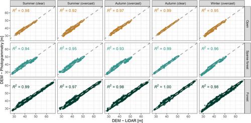
We compared DEMs and CHMs derived from drone photogrammetry with DEMs and CHMs produced from a drone-mounted laser scanner across three seasons with different solar illumination, tree foliage and weather conditions during leaf-off and leaf-on seasons. Photogrammetric height models were evaluated across three land-cover classes consisting of open areas, sparse-forest and forest. The most accurate CHM for sparse-forest was produced during summer under overcast conditions, whereas for the forest class, summer under clear skies was best.
Results
Structure from motion (SfM) photogrammetry performed well against the LiDAR survey in most cases with correlations between sampled points of up to R2 = 0.995. Root mean square errors (RMSEs) were <1.5 m in all DEMs and as low as 0.31 m in autumn clear-sky data over open terrain. CHM RMSEs were somewhat higher in all cases except under winter overcast conditions when the RMSE for sparse-forest reached 6.03 m.
Conclusions
We have shown that SfM photogrammetry is surprisingly robust to variations in vegetation type, tree phenology and weather, and performs well in comparison with a reference LiDAR data set. Our results show that, in boreal forests, autumn is the preferred season under clear-sky conditions for DEM generation from SfM photogrammetry across all land-cover classes, whereas summer is preferred for CHM modelling with a small trade-off between overcast and clear-sky conditions over different vegetation types. These results can help potential SfM users in ecology and forestry plan missions and review the quality of products derived from drone photogrammetry products.
 求助内容:
求助内容: 应助结果提醒方式:


