Patrick Marchesiello, Grégoire Thoumyre, Arame Dieye, Rafael Almar, Erwin Bergsma, Bamol Ali Sow, Hai Thuan Duong
{"title":"Exploring Fine-Scale Satellite-Derived Coastal Bathymetry for Ocean Modeling: A Case Study from West Africa","authors":"Patrick Marchesiello, Grégoire Thoumyre, Arame Dieye, Rafael Almar, Erwin Bergsma, Bamol Ali Sow, Hai Thuan Duong","doi":"10.1007/s12237-024-01398-9","DOIUrl":null,"url":null,"abstract":"<p>Coastal risk assessment requires accurate coastal bathymetry, which is largely lacking in many regions of the world’s coastal oceans. This is particularly true in Guinea-Bissau, where the tidal range is the highest of any country in West Africa, affecting several socio-economic sectors such as agriculture and urban development. Here, we present a selection of coastal bathymetry datasets available for generally poorly sampled coastal regions. These include the General Bathymetric Chart of the Oceans (GEBCO), digital nautical charts (CMAP), and depth retrieval from satellite wave detection (S2Shores). While GEBCO provides the right regional envelope of bathymetry, the coastal zone is plagued with random bumpiness at scales below 10 km (“orange peel” texture). S2Shores can be used to correct these errors and instead reveal the presence of small-scale channels, reminiscent of very high-resolution satellite color images. These structures are also confirmed by nautical charts, which show the channels to be well correlated but deeper than that indicated by the satellite retrieval (with a 40% higher variance, and 40 m instead of 20 m for Orango, the main and deepest channel). Simulations with a coastal ocean hydro-sedimentary model (CROCO) further show that submerged rivers can help drive a smooth flow of tidal energy into the main estuary of Guinea-Bissau. Tidal energy flux is better channeled in the CMAP and S2shores cases, while GEBCO produces an order of magnitude greater form drag, resulting in a stronger response from the sediment bed. Tides therefore have the effect of smoothing bathymetry along fine-scale channels, minimizing friction on the way to equilibrium. This result highlights the potential of combining different approaches to estimate updated coastal bathymetry and its effect on coastal dynamics in the most challenging areas.</p>","PeriodicalId":11921,"journal":{"name":"Estuaries and Coasts","volume":"12 1","pages":""},"PeriodicalIF":2.3000,"publicationDate":"2024-07-27","publicationTypes":"Journal Article","fieldsOfStudy":null,"isOpenAccess":false,"openAccessPdf":"","citationCount":"0","resultStr":null,"platform":"Semanticscholar","paperid":null,"PeriodicalName":"Estuaries and Coasts","FirstCategoryId":"93","ListUrlMain":"https://doi.org/10.1007/s12237-024-01398-9","RegionNum":3,"RegionCategory":"环境科学与生态学","ArticlePicture":[],"TitleCN":null,"AbstractTextCN":null,"PMCID":null,"EPubDate":"","PubModel":"","JCR":"Q3","JCRName":"ENVIRONMENTAL SCIENCES","Score":null,"Total":0}
引用次数: 0
Abstract
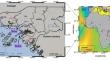
Coastal risk assessment requires accurate coastal bathymetry, which is largely lacking in many regions of the world’s coastal oceans. This is particularly true in Guinea-Bissau, where the tidal range is the highest of any country in West Africa, affecting several socio-economic sectors such as agriculture and urban development. Here, we present a selection of coastal bathymetry datasets available for generally poorly sampled coastal regions. These include the General Bathymetric Chart of the Oceans (GEBCO), digital nautical charts (CMAP), and depth retrieval from satellite wave detection (S2Shores). While GEBCO provides the right regional envelope of bathymetry, the coastal zone is plagued with random bumpiness at scales below 10 km (“orange peel” texture). S2Shores can be used to correct these errors and instead reveal the presence of small-scale channels, reminiscent of very high-resolution satellite color images. These structures are also confirmed by nautical charts, which show the channels to be well correlated but deeper than that indicated by the satellite retrieval (with a 40% higher variance, and 40 m instead of 20 m for Orango, the main and deepest channel). Simulations with a coastal ocean hydro-sedimentary model (CROCO) further show that submerged rivers can help drive a smooth flow of tidal energy into the main estuary of Guinea-Bissau. Tidal energy flux is better channeled in the CMAP and S2shores cases, while GEBCO produces an order of magnitude greater form drag, resulting in a stronger response from the sediment bed. Tides therefore have the effect of smoothing bathymetry along fine-scale channels, minimizing friction on the way to equilibrium. This result highlights the potential of combining different approaches to estimate updated coastal bathymetry and its effect on coastal dynamics in the most challenging areas.
期刊介绍:
Estuaries and Coasts is the journal of the Coastal and Estuarine Research Federation (CERF). Begun in 1977 as Chesapeake Science, the journal has gradually expanded its scope and circulation. Today, the journal publishes scholarly manuscripts on estuarine and near coastal ecosystems at the interface between the land and the sea where there are tidal fluctuations or sea water is diluted by fresh water. The interface is broadly defined to include estuaries and nearshore coastal waters including lagoons, wetlands, tidal fresh water, shores and beaches, but not the continental shelf. The journal covers research on physical, chemical, geological or biological processes, as well as applications to management of estuaries and coasts. The journal publishes original research findings, reviews and perspectives, techniques, comments, and management applications. Estuaries and Coasts will consider properly carried out studies that present inconclusive findings or document a failed replication of previously published work. Submissions that are primarily descriptive, strongly place-based, or only report on development of models or new methods without detailing their applications fall outside the scope of the journal.
 求助内容:
求助内容: 应助结果提醒方式:


