Raquel Portes, Diogo Spinola, Michael E. Ketterer, Markus Egli, Rebecca A. Lybrand, Jennifer Fedenko, Frances Biles, Thomas P. Trainor, Ashlee Dere, David V. D'Amore
{"title":"Assessing decadal soil redistribution rates using 239+240Pu across diverse lithologies in Southeast Alaska","authors":"Raquel Portes, Diogo Spinola, Michael E. Ketterer, Markus Egli, Rebecca A. Lybrand, Jennifer Fedenko, Frances Biles, Thomas P. Trainor, Ashlee Dere, David V. D'Amore","doi":"10.1002/saj2.20732","DOIUrl":null,"url":null,"abstract":"<p>Quantifying soil redistribution rates, including both erosion and deposition, is critical for understanding erosion processes, landscape evolution, land management strategies, and the carbon cycle. In the Northeast Pacific coastal temperate rainforest, the interaction of perhumid climate and dense coniferous forest tends to form Spodosols which are soils characterized by a subsurface accumulation of organic matter and iron and aluminum oxides, across a range of contrasting lithologies. Deep Spodosols are frequently found on steep backslopes (up to 60%) of colluvial deposits, where shallower soils would typically be expected. We hypothesized that deep Spodosols in Southeast Alaska indicate slope stability, exhibiting negligible soil redistribution rates and stable surfaces regardless of the lithology. Our objective was to quantify soil redistribution rates for Spodosols formed on steep slopes across a range of lithologies in hilly and mountainous areas of Juneau, AK. We used <sup>239+240</sup>Pu isotopes to quantify soil erosion and deposition rates in Spodosols formed on colluvial deposits from tonalite, slate, metavolcanic rock, and phyllite. <sup>239+240</sup>Pu measurements revealed negligible soil redistribution rates for all studied pedons, ranging from erosion rates of 0.51 t/ha/year to deposition rates up to 0.43 t/ha/year. No difference was detected between the hill and mountain landforms, further supporting the idea that Spodosols could indicate slope stability over decadal timescales across the region. Understanding the resilience of Spodosols to erosion processes in varied lithologies and landforms on steep slopes is paramount for making informed decisions regarding sustainable land use, landslide risk mitigation, and effective carbon sequestration strategies.</p>","PeriodicalId":101043,"journal":{"name":"Proceedings - Soil Science Society of America","volume":"88 5","pages":"1659-1677"},"PeriodicalIF":0.0000,"publicationDate":"2024-07-23","publicationTypes":"Journal Article","fieldsOfStudy":null,"isOpenAccess":false,"openAccessPdf":"https://onlinelibrary.wiley.com/doi/epdf/10.1002/saj2.20732","citationCount":"0","resultStr":null,"platform":"Semanticscholar","paperid":null,"PeriodicalName":"Proceedings - Soil Science Society of America","FirstCategoryId":"1085","ListUrlMain":"https://onlinelibrary.wiley.com/doi/10.1002/saj2.20732","RegionNum":0,"RegionCategory":null,"ArticlePicture":[],"TitleCN":null,"AbstractTextCN":null,"PMCID":null,"EPubDate":"","PubModel":"","JCR":"","JCRName":"","Score":null,"Total":0}
引用次数: 0
Abstract
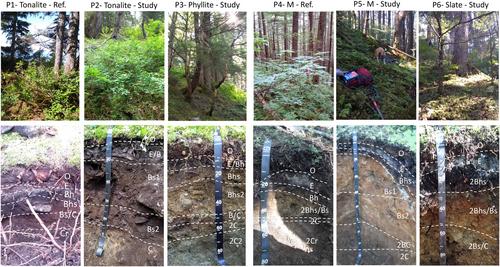
Quantifying soil redistribution rates, including both erosion and deposition, is critical for understanding erosion processes, landscape evolution, land management strategies, and the carbon cycle. In the Northeast Pacific coastal temperate rainforest, the interaction of perhumid climate and dense coniferous forest tends to form Spodosols which are soils characterized by a subsurface accumulation of organic matter and iron and aluminum oxides, across a range of contrasting lithologies. Deep Spodosols are frequently found on steep backslopes (up to 60%) of colluvial deposits, where shallower soils would typically be expected. We hypothesized that deep Spodosols in Southeast Alaska indicate slope stability, exhibiting negligible soil redistribution rates and stable surfaces regardless of the lithology. Our objective was to quantify soil redistribution rates for Spodosols formed on steep slopes across a range of lithologies in hilly and mountainous areas of Juneau, AK. We used 239+240Pu isotopes to quantify soil erosion and deposition rates in Spodosols formed on colluvial deposits from tonalite, slate, metavolcanic rock, and phyllite. 239+240Pu measurements revealed negligible soil redistribution rates for all studied pedons, ranging from erosion rates of 0.51 t/ha/year to deposition rates up to 0.43 t/ha/year. No difference was detected between the hill and mountain landforms, further supporting the idea that Spodosols could indicate slope stability over decadal timescales across the region. Understanding the resilience of Spodosols to erosion processes in varied lithologies and landforms on steep slopes is paramount for making informed decisions regarding sustainable land use, landslide risk mitigation, and effective carbon sequestration strategies.

 求助内容:
求助内容: 应助结果提醒方式:


