{"title":"Integrating in-situ data and spatial decision support systems (SDSS) to identify groundwater potential sites in the Esan plateau, Nigeria","authors":"Kesyton Oyamenda Ozegin , Stephen Olubusola Ilugbo , Owens Monday Alile , Kenneth Iluore","doi":"10.1016/j.gsd.2024.101276","DOIUrl":null,"url":null,"abstract":"<div><p>Establishing suitable groundwater resource areas is a challenging endeavour across the globe. However, novel spatial technologies have emerged as valuable tools for the effective strategy, management, and assessment of groundwater resources, especially in data-scarce emerging economies. The current study used spatial decision support systems (SDSS) for evaluating and defining groundwater potential sites (GPSs) in Nigeria's Edo central region to promote sustainable governance of groundwater. By merging multiple groundwater contributing theme layers, a leading-edge information-based multiparametric analytical hierarchy process (AHP) was applied to define the groundwater prospective areas. By systematically assigning weights to every subject-specific layer and feature, the subject matter layers of geology, geomorphology, drainage density, slope, soil properties, landuse/landcover, rainfall distribution, hydraulic conductivity, transmissivity, curvature, proximity to surface water bodies, and elevation were generated and used for groundwater potential map generation. Each thematic layer's weights were allocated and adjusted depending on their qualities and relevance to groundwater recharge. The multicollinearity (MC) analysis was used to evaluate the model's predictive capacity. Finally, groundwater potential sites were created by integrating the theme-specific maps with the weighted total overlay computation tool. The study area contained three separate groundwater potential sites: low, moderate, and high. According to the regional geographic distribution, the largest portion of the area (65%) fell within the moderately significant groundwater potential geographical area. The high and low GPSs, which both have a low curvature and a valley plain characteristic, account for 25% and 10%, respectively, of the entire area. The outcomes were contrasted with the yield of groundwater from boreholes gathered in the study region. The validation analysis found an acceptable 88.89% similarity. This highlights the potential for the groundwater map's significant prediction. Therefore, the applied approach is a viable choice for the advancement of groundwater in the central Edo region and with comparable geology all over the globe.</p></div>","PeriodicalId":37879,"journal":{"name":"Groundwater for Sustainable Development","volume":"26 ","pages":"Article 101276"},"PeriodicalIF":4.9000,"publicationDate":"2024-07-14","publicationTypes":"Journal Article","fieldsOfStudy":null,"isOpenAccess":false,"openAccessPdf":"","citationCount":"0","resultStr":null,"platform":"Semanticscholar","paperid":null,"PeriodicalName":"Groundwater for Sustainable Development","FirstCategoryId":"1085","ListUrlMain":"https://www.sciencedirect.com/science/article/pii/S2352801X24001991","RegionNum":0,"RegionCategory":null,"ArticlePicture":[],"TitleCN":null,"AbstractTextCN":null,"PMCID":null,"EPubDate":"","PubModel":"","JCR":"Q2","JCRName":"ENGINEERING, ENVIRONMENTAL","Score":null,"Total":0}
引用次数: 0
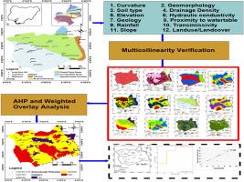
Abstract
Establishing suitable groundwater resource areas is a challenging endeavour across the globe. However, novel spatial technologies have emerged as valuable tools for the effective strategy, management, and assessment of groundwater resources, especially in data-scarce emerging economies. The current study used spatial decision support systems (SDSS) for evaluating and defining groundwater potential sites (GPSs) in Nigeria's Edo central region to promote sustainable governance of groundwater. By merging multiple groundwater contributing theme layers, a leading-edge information-based multiparametric analytical hierarchy process (AHP) was applied to define the groundwater prospective areas. By systematically assigning weights to every subject-specific layer and feature, the subject matter layers of geology, geomorphology, drainage density, slope, soil properties, landuse/landcover, rainfall distribution, hydraulic conductivity, transmissivity, curvature, proximity to surface water bodies, and elevation were generated and used for groundwater potential map generation. Each thematic layer's weights were allocated and adjusted depending on their qualities and relevance to groundwater recharge. The multicollinearity (MC) analysis was used to evaluate the model's predictive capacity. Finally, groundwater potential sites were created by integrating the theme-specific maps with the weighted total overlay computation tool. The study area contained three separate groundwater potential sites: low, moderate, and high. According to the regional geographic distribution, the largest portion of the area (65%) fell within the moderately significant groundwater potential geographical area. The high and low GPSs, which both have a low curvature and a valley plain characteristic, account for 25% and 10%, respectively, of the entire area. The outcomes were contrasted with the yield of groundwater from boreholes gathered in the study region. The validation analysis found an acceptable 88.89% similarity. This highlights the potential for the groundwater map's significant prediction. Therefore, the applied approach is a viable choice for the advancement of groundwater in the central Edo region and with comparable geology all over the globe.
期刊介绍:
Groundwater for Sustainable Development is directed to different stakeholders and professionals, including government and non-governmental organizations, international funding agencies, universities, public water institutions, public health and other public/private sector professionals, and other relevant institutions. It is aimed at professionals, academics and students in the fields of disciplines such as: groundwater and its connection to surface hydrology and environment, soil sciences, engineering, ecology, microbiology, atmospheric sciences, analytical chemistry, hydro-engineering, water technology, environmental ethics, economics, public health, policy, as well as social sciences, legal disciplines, or any other area connected with water issues. The objectives of this journal are to facilitate: • The improvement of effective and sustainable management of water resources across the globe. • The improvement of human access to groundwater resources in adequate quantity and good quality. • The meeting of the increasing demand for drinking and irrigation water needed for food security to contribute to a social and economically sound human development. • The creation of a global inter- and multidisciplinary platform and forum to improve our understanding of groundwater resources and to advocate their effective and sustainable management and protection against contamination. • Interdisciplinary information exchange and to stimulate scientific research in the fields of groundwater related sciences and social and health sciences required to achieve the United Nations Millennium Development Goals for sustainable development.

 求助内容:
求助内容: 应助结果提醒方式:


