Integration of remote sensing, geochemical modeling, and isotopic constraints for the detection of promising groundwater zones in arid regions. A study in Qena- Luxor area, Egypt
Mohamed Hassan Ramzy , Mustafa Eissa , Shaimaa M. El-Hadidy , Samah Mahmoud Morsy
{"title":"Integration of remote sensing, geochemical modeling, and isotopic constraints for the detection of promising groundwater zones in arid regions. A study in Qena- Luxor area, Egypt","authors":"Mohamed Hassan Ramzy , Mustafa Eissa , Shaimaa M. El-Hadidy , Samah Mahmoud Morsy","doi":"10.1016/j.gsd.2024.101266","DOIUrl":null,"url":null,"abstract":"<div><p>The renewable groundwater resources in Egypt are restricted close to the Nile River. In the study area, two major water bearings are near the Nile: The Quaternary and the Eocene aquifers. Remote sensing (ASTER DEM, Landsat-8, and Sentinal-1 InSAR images), geochemical modeling, and isotopic constraints (δ<sup>18</sup>O and δ<sup>2</sup>H) were employed and integrated with the GIS framework for delineating the low saline and sustainable groundwater zones. Remote sensing data indicates intensive structure lineaments in the middle-eastward part, spatially congruent with subsurface features deduced from radar satellites, facilitating hydraulic connections with the Nile water. The soil moisture index, land surface temperature, and salinity index in irrigated areas, reveal a strong association between in situ electrical conductivity values and satellite-derived spectral indices. The higher groundwater salinity in the middle eastern region coincided with high lineament density zones, and higher temperature zones, leading to increased rock water interaction that leads to groundwater salinization. The isotopic composition of the Quaternary aquifer ranges between −1.30 ‰ and +5.53 ‰ for δ<sup>18</sup>O, while δ<sup>2</sup>H ranges between −11.49 ‰ and +34.47 ‰. In the Eocene aquifer, δ<sup>18</sup>O ranges between −0.46 and +3.45 ‰, while the δ<sup>2</sup>H ranges between −3.16 ‰ and +23.50 ‰, indicating subsurface recharge from the Nile water. The simulation of the mass transport geochemical NETPATH model revealed mixing ratios from the Nile water ranging from 3.4% to 93.7%. Based on the results, the area is classified into four classes, class (1) represents samples of high conduit with Nile water (<<strong>50</strong>% mixing), class (2) represents samples of moderate conduit with Nile water (10–50% mixing), class (3) represents samples of low conduit with Nile water (<1–10% mixing), class (4) represents samples of water-rock interaction. The findings would be of great importance for delineating sustainable zones of the Nile Valley aquifers.</p></div>","PeriodicalId":37879,"journal":{"name":"Groundwater for Sustainable Development","volume":"26 ","pages":"Article 101266"},"PeriodicalIF":4.9000,"publicationDate":"2024-07-01","publicationTypes":"Journal Article","fieldsOfStudy":null,"isOpenAccess":false,"openAccessPdf":"","citationCount":"0","resultStr":null,"platform":"Semanticscholar","paperid":null,"PeriodicalName":"Groundwater for Sustainable Development","FirstCategoryId":"1085","ListUrlMain":"https://www.sciencedirect.com/science/article/pii/S2352801X24001899","RegionNum":0,"RegionCategory":null,"ArticlePicture":[],"TitleCN":null,"AbstractTextCN":null,"PMCID":null,"EPubDate":"","PubModel":"","JCR":"Q2","JCRName":"ENGINEERING, ENVIRONMENTAL","Score":null,"Total":0}
引用次数: 0
Abstract
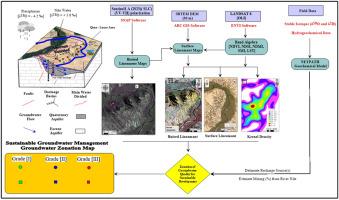
The renewable groundwater resources in Egypt are restricted close to the Nile River. In the study area, two major water bearings are near the Nile: The Quaternary and the Eocene aquifers. Remote sensing (ASTER DEM, Landsat-8, and Sentinal-1 InSAR images), geochemical modeling, and isotopic constraints (δ18O and δ2H) were employed and integrated with the GIS framework for delineating the low saline and sustainable groundwater zones. Remote sensing data indicates intensive structure lineaments in the middle-eastward part, spatially congruent with subsurface features deduced from radar satellites, facilitating hydraulic connections with the Nile water. The soil moisture index, land surface temperature, and salinity index in irrigated areas, reveal a strong association between in situ electrical conductivity values and satellite-derived spectral indices. The higher groundwater salinity in the middle eastern region coincided with high lineament density zones, and higher temperature zones, leading to increased rock water interaction that leads to groundwater salinization. The isotopic composition of the Quaternary aquifer ranges between −1.30 ‰ and +5.53 ‰ for δ18O, while δ2H ranges between −11.49 ‰ and +34.47 ‰. In the Eocene aquifer, δ18O ranges between −0.46 and +3.45 ‰, while the δ2H ranges between −3.16 ‰ and +23.50 ‰, indicating subsurface recharge from the Nile water. The simulation of the mass transport geochemical NETPATH model revealed mixing ratios from the Nile water ranging from 3.4% to 93.7%. Based on the results, the area is classified into four classes, class (1) represents samples of high conduit with Nile water (<50% mixing), class (2) represents samples of moderate conduit with Nile water (10–50% mixing), class (3) represents samples of low conduit with Nile water (<1–10% mixing), class (4) represents samples of water-rock interaction. The findings would be of great importance for delineating sustainable zones of the Nile Valley aquifers.
期刊介绍:
Groundwater for Sustainable Development is directed to different stakeholders and professionals, including government and non-governmental organizations, international funding agencies, universities, public water institutions, public health and other public/private sector professionals, and other relevant institutions. It is aimed at professionals, academics and students in the fields of disciplines such as: groundwater and its connection to surface hydrology and environment, soil sciences, engineering, ecology, microbiology, atmospheric sciences, analytical chemistry, hydro-engineering, water technology, environmental ethics, economics, public health, policy, as well as social sciences, legal disciplines, or any other area connected with water issues. The objectives of this journal are to facilitate: • The improvement of effective and sustainable management of water resources across the globe. • The improvement of human access to groundwater resources in adequate quantity and good quality. • The meeting of the increasing demand for drinking and irrigation water needed for food security to contribute to a social and economically sound human development. • The creation of a global inter- and multidisciplinary platform and forum to improve our understanding of groundwater resources and to advocate their effective and sustainable management and protection against contamination. • Interdisciplinary information exchange and to stimulate scientific research in the fields of groundwater related sciences and social and health sciences required to achieve the United Nations Millennium Development Goals for sustainable development.

 求助内容:
求助内容: 应助结果提醒方式:


