Comparing grass biomass estimation methods for management decisions in a semi-arid landscape
Abstract
Aims
Environmental managers require reliable and cost-efficient monitoring methods for effective decision-making. Understanding forage availability is important for managing wild, vertebrate herbivore populations. We developed a process for exploring the accuracy and cost efficiency of various biomass estimation techniques for a case study where semi-arid woodland restoration is threatened by kangaroo grazing, with the aim of determining which method was most fit for purpose in a given decision context.
Location
Wyperfeld National Park, southeastern Australia.
Methods
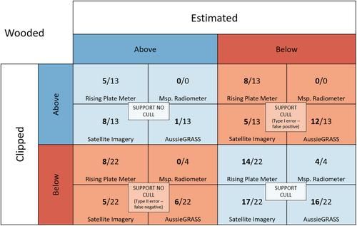
Grass biomass was estimated using a variety of methods, then compared to clipped biomass using linear models. Biomass estimation methods were either field-based (i.e., rising plate meter, multispectral radiometer) or satellite-based (i.e., Landsat satellite imagery, AussieGRASS forage production model). Sampling occurred across open and wooded semi-arid vegetation types. We compared methods based on accuracy, the ability of each method to accurately predict a ‘forage-switch’ threshold, cost, and the suitability for the management context.
Results
For this case study, the multispectral radiometer was the most precise, yet most expensive, biomass estimation method over a single survey. However, satellite imagery proved to be the most cost-efficient and fit for purpose, as it was inexpensive and most accurately estimated biomass around a forage-switch threshold, second only to the multispectral radiometer. Accuracy of all methods was improved by including tree cover in the regression models.
Conclusions
We demonstrate a process for exploring which biomass estimation tool might be preferred for a given decision context, highlighting accuracy, consideration of tolerance to uncertainty and risk, the spatial and temporal scale of information required, and budget constraints.
 求助内容:
求助内容: 应助结果提醒方式:


