{"title":"Volcanic disaster scene classification of remote sensing image based on deep multi-instance network","authors":"Chengfan Li, Jingxin Han, Chengzhi Wu, Lan Liu, Xuefeng Liu, Junjuan Zhao","doi":"10.1007/s11600-024-01394-4","DOIUrl":null,"url":null,"abstract":"<div><p>Due to the varieties, random distributions, and rich visual characteristics of the volcanic disaster scene, traditional methods fail to fully express the complex features of volcanic disaster scenes in remote sensing images. To tackle this problem, a new multi-instance network framework with the Shift Windows Transformer (i.e., Swin-T) and attention mechanism is used to classify the volcanic disaster scene from remote sensing images (MI-STA). Firstly, via aggregating the global contextual information of remote sensing image features, the Swin-T extracts the multi-scale hierarchical features of volcano disaster scenes from remote sensing images. Secondly, the channel attention module and spatial attention module fuse to extract the features of volcanic disaster scene to enhance the description and representation for the local details and global information in volcanic disaster scenes. Last, the importance weight of different example characteristics is scored to calculate the attributive probabilities of each instance. This study elaborates an experiment on the xBD dataset and gives comparisons with the commonly used deep network models. The results show that the overall classification accuracy of the proposed method achieves 92.46% and has good performance on the test dataset. Then, we further utilize our model to classify the volcanic disaster scenes of the specific Hunga Tonga-Hunga Ha’apai on January 15, 2022, and the classification images have good consistency with the existing literature. It provides a new approach for volcanic disaster monitoring by means of remote sensing image and has broad application prospects.</p></div>","PeriodicalId":6988,"journal":{"name":"Acta Geophysica","volume":"73 1","pages":"25 - 41"},"PeriodicalIF":2.3000,"publicationDate":"2024-06-18","publicationTypes":"Journal Article","fieldsOfStudy":null,"isOpenAccess":false,"openAccessPdf":"","citationCount":"0","resultStr":null,"platform":"Semanticscholar","paperid":null,"PeriodicalName":"Acta Geophysica","FirstCategoryId":"89","ListUrlMain":"https://link.springer.com/article/10.1007/s11600-024-01394-4","RegionNum":4,"RegionCategory":"地球科学","ArticlePicture":[],"TitleCN":null,"AbstractTextCN":null,"PMCID":null,"EPubDate":"","PubModel":"","JCR":"","JCRName":"","Score":null,"Total":0}
引用次数: 0
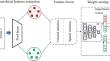
Abstract
Due to the varieties, random distributions, and rich visual characteristics of the volcanic disaster scene, traditional methods fail to fully express the complex features of volcanic disaster scenes in remote sensing images. To tackle this problem, a new multi-instance network framework with the Shift Windows Transformer (i.e., Swin-T) and attention mechanism is used to classify the volcanic disaster scene from remote sensing images (MI-STA). Firstly, via aggregating the global contextual information of remote sensing image features, the Swin-T extracts the multi-scale hierarchical features of volcano disaster scenes from remote sensing images. Secondly, the channel attention module and spatial attention module fuse to extract the features of volcanic disaster scene to enhance the description and representation for the local details and global information in volcanic disaster scenes. Last, the importance weight of different example characteristics is scored to calculate the attributive probabilities of each instance. This study elaborates an experiment on the xBD dataset and gives comparisons with the commonly used deep network models. The results show that the overall classification accuracy of the proposed method achieves 92.46% and has good performance on the test dataset. Then, we further utilize our model to classify the volcanic disaster scenes of the specific Hunga Tonga-Hunga Ha’apai on January 15, 2022, and the classification images have good consistency with the existing literature. It provides a new approach for volcanic disaster monitoring by means of remote sensing image and has broad application prospects.
期刊介绍:
Acta Geophysica is open to all kinds of manuscripts including research and review articles, short communications, comments to published papers, letters to the Editor as well as book reviews. Some of the issues are fully devoted to particular topics; we do encourage proposals for such topical issues. We accept submissions from scientists world-wide, offering high scientific and editorial standard and comprehensive treatment of the discussed topics.

 求助内容:
求助内容: 应助结果提醒方式:


