Substantial contribution of slush to meltwater area across Antarctic ice shelves
IF 16.1
1区 地球科学
Q1 GEOSCIENCES, MULTIDISCIPLINARY
引用次数: 0
Abstract
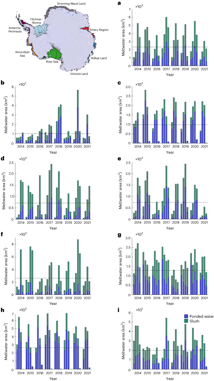
Surface melting occurs across many of Antarctica’s ice shelves, mainly during the austral summer. The onset, duration, area and fate of surface melting varies spatially and temporally, and the resultant surface meltwater is stored as ponded water (lakes) or as slush (saturated firn or snow), with implications for ice-shelf hydrofracture, firn air content reduction, surface energy balance and thermal evolution. This study applies a machine-learning method to the entire Landsat 8 image catalogue to derive monthly records of slush and ponded water area across 57 ice shelves between 2013 and 2021. We find that slush and ponded water occupy roughly equal areas of Antarctica’s ice shelves in January, with inter-regional variations in partitioning. This suggests that studies that neglect slush may substantially underestimate the area of ice shelves covered by surface meltwater. Furthermore, we found that adjusting the surface albedo in a regional climate model to account for the lower albedo of surface meltwater resulted in 2.8 times greater snowmelt across five representative ice shelves. This extra melt is currently unaccounted for in regional climate models, which may lead to underestimates in projections of ice-sheet melting and ice-shelf stability. Analysis of satellite imagery suggests that slush accounts for approximately half of the total meltwater area across Antarctic ice shelves.


南极冰架上的泥泞对融水面积贡献巨大
南极洲的许多冰架都会发生地表融化,主要发生在夏季。地表融化的开始时间、持续时间、面积和结果在空间和时间上各不相同,由此产生的地表融水以积水(湖泊)或泥浆(饱和枞树或雪)的形式储存,对冰架水力断裂、枞树空气含量减少、地表能量平衡和热演化产生影响。本研究将一种机器学习方法应用于整个大地遥感卫星 8 号图像目录,得出了 2013 年至 2021 年期间 57 个冰架的淤泥和积水面积月度记录。我们发现,1 月份南极洲冰架上的淤泥和积水所占面积大致相同,但区域间的划分存在差异。这表明,忽略泥泞水的研究可能会大大低估表面融水覆盖的冰架面积。此外,我们还发现,调整区域气候模型中的地表反照率,以考虑地表融水较低的反照率,会导致五个代表性冰架的融雪量增加 2.8 倍。这种额外的融雪目前在区域气候模式中没有计算在内,这可能会导致对冰盖融化和冰架稳定性预测的低估。
本文章由计算机程序翻译,如有差异,请以英文原文为准。
求助全文
约1分钟内获得全文
求助全文
来源期刊

Nature Geoscience
地学-地球科学综合
CiteScore
26.70
自引率
1.60%
发文量
187
审稿时长
3.3 months
期刊介绍:
Nature Geoscience is a monthly interdisciplinary journal that gathers top-tier research spanning Earth Sciences and related fields.
The journal covers all geoscience disciplines, including fieldwork, modeling, and theoretical studies.
Topics include atmospheric science, biogeochemistry, climate science, geobiology, geochemistry, geoinformatics, remote sensing, geology, geomagnetism, paleomagnetism, geomorphology, geophysics, glaciology, hydrology, limnology, mineralogy, oceanography, paleontology, paleoclimatology, paleoceanography, petrology, planetary science, seismology, space physics, tectonics, and volcanology.
Nature Geoscience upholds its commitment to publishing significant, high-quality Earth Sciences research through fair, rapid, and rigorous peer review, overseen by a team of full-time professional editors.
 求助内容:
求助内容: 应助结果提醒方式:


