Seasonal variability of high-latitude foraging grounds for Atlantic bluefin tuna (Thunnus thynnus)

IF 4.6 2区 环境科学与生态学 Q1 BIODIVERSITY CONSERVATION
Grace E. McNicholas, Andrew L. Jackson, Stephanie Brodie, Ross O'Neill, Niall Ó'Maoiléidigh, Alan Drumm, Joseph Cooney, Hugo Maxwell, Barbara Block, Mike Castleton, Robert Schallert, Nicholas L. Payne
{"title":"Seasonal variability of high-latitude foraging grounds for Atlantic bluefin tuna (Thunnus thynnus)","authors":"Grace E. McNicholas,&nbsp;Andrew L. Jackson,&nbsp;Stephanie Brodie,&nbsp;Ross O'Neill,&nbsp;Niall Ó'Maoiléidigh,&nbsp;Alan Drumm,&nbsp;Joseph Cooney,&nbsp;Hugo Maxwell,&nbsp;Barbara Block,&nbsp;Mike Castleton,&nbsp;Robert Schallert,&nbsp;Nicholas L. Payne","doi":"10.1111/ddi.13865","DOIUrl":null,"url":null,"abstract":"<div>\n \n \n <section>\n \n <h3> Aim</h3>\n \n <p>Predicting spatial and temporal changes in species distributions is difficult for highly mobile species, making effective management challenging. We aim to understand the seasonal variability in habitat suitability for Atlantic bluefin tuna (<i>Thunnus thynnus</i>; ABFT) by using tracking data to create species distribution models.</p>\n </section>\n \n <section>\n \n <h3> Location</h3>\n \n <p>North-east Atlantic Ocean.</p>\n </section>\n \n <section>\n \n <h3> Methods</h3>\n \n <p>Forty-nine ABFT were tagged with pop-up archival satellite tags along the west coast of Ireland during successive autumns from 2016 to 2021. Four thousand two hundred and sixteen daily locations were used to build a habitat model to describe ABFT environmental preferences and habitat suitability. For each location, 100 ‘pseudoabsence’ locations were simulated using correlated random walks.</p>\n </section>\n \n <section>\n \n <h3> Results</h3>\n \n <p>Tags had a mean retention rate of 237 ± 107 days, resulting in 11,602 cumulative days at liberty, and a mean daily distance travelled of 51 ± 143 km. ABFT showed two primary migration routes from Ireland, travelling to the Bay of Biscay or across the Mid-Atlantic ridge in the winter. However, in 2019 six individuals travelled northwards towards Iceland, likely in response to a marine heatwave. Eight ABFT entered the Mediterranean in May/June for putative spawning, with six returning to Irish waters a year later. Five environmental covariates best described ABFT habitat, with habitat suitability highest at sea surface temperatures (SST) of 15–18°C, a mixed layer depth between ~200 and 300 m, high relief bathymetric features (i.e. shelf breaks and seamounts) and frontal regions as revealed by non-linear preferences of eddy kinetic energy and SST standard deviation.</p>\n </section>\n \n <section>\n \n <h3> Main Conclusions</h3>\n \n <p>In the last decade, ABFT have been re-establishing historic foraging grounds in higher latitudes, for example, Irish and Nordic waters. Our model shows the extent of suitable habitat in these regions and how recent ocean warming may have contributed to northern expansions. Understanding the drivers behind these reappearances is fundamental to successful future management.</p>\n </section>\n \n <section>\n \n <h3> Achoimre</h3>\n </section>\n \n <section>\n \n <h3> Aidhm</h3>\n \n <p>Tá sé deacair athraithe i ndáileadh ama agus spásdháileadh speiceas atá an-soghluaiste a thuar, rud a chiallaíonn go bhfuil sé dúshlánach bainistiú éifeachtach a dhéanamh. Tá muid ag iarraidh inathraitheacht shéasúrach in oiriúnacht ghnáthóg an Tuinnín Gorm Atlantach (<i>Thunnus thynnus</i>; TGA) a thuiscint tríd sonraí rianaithe a úsáid chun samhail dháileadh speiceas a chruthú.</p>\n </section>\n \n <section>\n \n <h3> Suíomh</h3>\n \n <p>Oirthuaisceart an Atlantaigh.</p>\n </section>\n \n <section>\n \n <h3> Modh</h3>\n \n <p>Rinneadh clibeadh ar 49 TGA le clibeanna cartlainne a thagann go barr uisce ar chósta iarthar na hÉireann le linn ceithre fhómhair i ndiaidh a chéile ó 2016–2021. Úsáideadh 4216 suíomhanna laethúil chun samhail ghnáthóg a chruthú a rinne cur síos ar roghanna timpeallachta agus oiriúnacht ghnáthóg an TGA. I gcomhair gach suíomh, ionsamhlaíodh 100 suíomhanna bréag-neamhláithreacht ag úsáid siúlóidí randamacha comhghaolaithe.</p>\n </section>\n \n <section>\n \n <h3> Torthaí</h3>\n \n <p>Bhí meán ráta coinneála de 237 ± 107 lá ag na clibeanna, rud a thug 11,602 lá taifeadta i ndiaidh a chéile agus meán fhad laethúil taistealta de 51 ± 143 km dá bharr. Léirigh TGA dhá phríomhbhealaí imirce ó hÉirinn, ag taisteal go Bá na Bioscáine nó thar Droim an Atlantaigh Láir i rith an gheimhridh. Ach i 2019 thaisteal sé iasc ó thuaidh i dtreo an Íoslainn, is dócha mar gheall ar thonn teasa mara. Chuaigh ocht TGA isteach sa Mheánmhuir i rith mí Bealtaine/mí an Mheitheamh chun uibheacha a sceitheadh de réir dealraimh. Tháinig sé dóibh ar ais go huiscí na hÉireann an bhliain dar gcionn. Déanann cúig athróg timpeallachta an cur síos is fearr ar ghnáthóg an TGA, tá oiriúnacht ghnáthóg is airde ag teocht barr uisce (TBA) de 15–18°C, nuair atá doimhneacht an chisil mheasctha idir ~200 agus 300 m, ag gnéithe bataiméadrach ard-rilíf (i.e. scoilteanna scairbhe agus tuláin grinnill), agus ag réigiúin frontacha léirithe ag roghanna neamh-líneacha fuinneamh cinéatach guairneánach agus diall caighdeánach TBA.</p>\n </section>\n \n <section>\n \n <h3> Príomhchonclúidí</h3>\n \n <p>Le leathscór bliain anuas tá TGA tar éis réigiúin sealgaireachta stairiúil a athbhunú in áiteanna le hard-domhanleithead, ar nós uiscí na hÉireann agus uiscí Nordacha. Taispeánann ár samhail achar an ghnáthóg oiriúnach sna réigiúin seo agus an bhaint féideartha a bhí ag téámh aigéanach le gairid ar leathadh ó thuaidh. Tá sé buntábhachtach na cúiseanna don athfhilleadh seo a thuiscint i gcomhair bainistiú rathúil amach anseo.</p>\n </section>\n </div>","PeriodicalId":51018,"journal":{"name":"Diversity and Distributions","volume":"30 8","pages":""},"PeriodicalIF":4.6000,"publicationDate":"2024-06-10","publicationTypes":"Journal Article","fieldsOfStudy":null,"isOpenAccess":false,"openAccessPdf":"https://onlinelibrary.wiley.com/doi/epdf/10.1111/ddi.13865","citationCount":"0","resultStr":null,"platform":"Semanticscholar","paperid":null,"PeriodicalName":"Diversity and Distributions","FirstCategoryId":"93","ListUrlMain":"https://onlinelibrary.wiley.com/doi/10.1111/ddi.13865","RegionNum":2,"RegionCategory":"环境科学与生态学","ArticlePicture":[],"TitleCN":null,"AbstractTextCN":null,"PMCID":null,"EPubDate":"","PubModel":"","JCR":"Q1","JCRName":"BIODIVERSITY CONSERVATION","Score":null,"Total":0}
引用次数: 0

Abstract

Aim

Predicting spatial and temporal changes in species distributions is difficult for highly mobile species, making effective management challenging. We aim to understand the seasonal variability in habitat suitability for Atlantic bluefin tuna (Thunnus thynnus; ABFT) by using tracking data to create species distribution models.

Location

North-east Atlantic Ocean.

Methods

Forty-nine ABFT were tagged with pop-up archival satellite tags along the west coast of Ireland during successive autumns from 2016 to 2021. Four thousand two hundred and sixteen daily locations were used to build a habitat model to describe ABFT environmental preferences and habitat suitability. For each location, 100 ‘pseudoabsence’ locations were simulated using correlated random walks.

Results

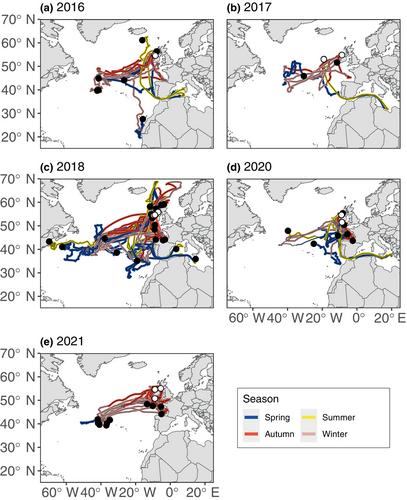
Tags had a mean retention rate of 237 ± 107 days, resulting in 11,602 cumulative days at liberty, and a mean daily distance travelled of 51 ± 143 km. ABFT showed two primary migration routes from Ireland, travelling to the Bay of Biscay or across the Mid-Atlantic ridge in the winter. However, in 2019 six individuals travelled northwards towards Iceland, likely in response to a marine heatwave. Eight ABFT entered the Mediterranean in May/June for putative spawning, with six returning to Irish waters a year later. Five environmental covariates best described ABFT habitat, with habitat suitability highest at sea surface temperatures (SST) of 15–18°C, a mixed layer depth between ~200 and 300 m, high relief bathymetric features (i.e. shelf breaks and seamounts) and frontal regions as revealed by non-linear preferences of eddy kinetic energy and SST standard deviation.

Main Conclusions

In the last decade, ABFT have been re-establishing historic foraging grounds in higher latitudes, for example, Irish and Nordic waters. Our model shows the extent of suitable habitat in these regions and how recent ocean warming may have contributed to northern expansions. Understanding the drivers behind these reappearances is fundamental to successful future management.

Achoimre

Aidhm

Tá sé deacair athraithe i ndáileadh ama agus spásdháileadh speiceas atá an-soghluaiste a thuar, rud a chiallaíonn go bhfuil sé dúshlánach bainistiú éifeachtach a dhéanamh. Tá muid ag iarraidh inathraitheacht shéasúrach in oiriúnacht ghnáthóg an Tuinnín Gorm Atlantach (Thunnus thynnus; TGA) a thuiscint tríd sonraí rianaithe a úsáid chun samhail dháileadh speiceas a chruthú.

Suíomh

Oirthuaisceart an Atlantaigh.

Modh

Rinneadh clibeadh ar 49 TGA le clibeanna cartlainne a thagann go barr uisce ar chósta iarthar na hÉireann le linn ceithre fhómhair i ndiaidh a chéile ó 2016–2021. Úsáideadh 4216 suíomhanna laethúil chun samhail ghnáthóg a chruthú a rinne cur síos ar roghanna timpeallachta agus oiriúnacht ghnáthóg an TGA. I gcomhair gach suíomh, ionsamhlaíodh 100 suíomhanna bréag-neamhláithreacht ag úsáid siúlóidí randamacha comhghaolaithe.

Torthaí

Bhí meán ráta coinneála de 237 ± 107 lá ag na clibeanna, rud a thug 11,602 lá taifeadta i ndiaidh a chéile agus meán fhad laethúil taistealta de 51 ± 143 km dá bharr. Léirigh TGA dhá phríomhbhealaí imirce ó hÉirinn, ag taisteal go Bá na Bioscáine nó thar Droim an Atlantaigh Láir i rith an gheimhridh. Ach i 2019 thaisteal sé iasc ó thuaidh i dtreo an Íoslainn, is dócha mar gheall ar thonn teasa mara. Chuaigh ocht TGA isteach sa Mheánmhuir i rith mí Bealtaine/mí an Mheitheamh chun uibheacha a sceitheadh de réir dealraimh. Tháinig sé dóibh ar ais go huiscí na hÉireann an bhliain dar gcionn. Déanann cúig athróg timpeallachta an cur síos is fearr ar ghnáthóg an TGA, tá oiriúnacht ghnáthóg is airde ag teocht barr uisce (TBA) de 15–18°C, nuair atá doimhneacht an chisil mheasctha idir ~200 agus 300 m, ag gnéithe bataiméadrach ard-rilíf (i.e. scoilteanna scairbhe agus tuláin grinnill), agus ag réigiúin frontacha léirithe ag roghanna neamh-líneacha fuinneamh cinéatach guairneánach agus diall caighdeánach TBA.

Príomhchonclúidí

Le leathscór bliain anuas tá TGA tar éis réigiúin sealgaireachta stairiúil a athbhunú in áiteanna le hard-domhanleithead, ar nós uiscí na hÉireann agus uiscí Nordacha. Taispeánann ár samhail achar an ghnáthóg oiriúnach sna réigiúin seo agus an bhaint féideartha a bhí ag téámh aigéanach le gairid ar leathadh ó thuaidh. Tá sé buntábhachtach na cúiseanna don athfhilleadh seo a thuiscint i gcomhair bainistiú rathúil amach anseo.
Abstract Image

大西洋蓝鳍金枪鱼(Thunnus thynnus)高纬度觅食地的季节性变化
预测物种分布的空间和时间变化对于高流动性物种来说非常困难,这使得有效管理具有挑战性。我们的目标是利用跟踪数据建立物种分布模型,从而了解大西洋蓝鳍金枪鱼(Thunnus thynnus; ABFT)栖息地适宜性的季节性变化。在2016年至2021年的连续几个秋天,我们在爱尔兰西海岸用弹出式存档卫星标签标记了49条大西洋蓝鳍金枪鱼。四千二百一十六个日定位点被用于建立栖息地模型,以描述ABFT的环境偏好和栖息地适宜性。标签的平均保留率为 237 ± 107 天,累计自由活动天数为 11,602 天,平均每日活动距离为 51 ± 143 千米。ABFT显示了从爱尔兰出发的两条主要迁徙路线,冬季前往比斯开湾或穿越大西洋中脊。不过,2019 年有 6 只个体向北前往冰岛,可能是为了应对海洋热浪。8 条 ABFT 在 5 月/6 月进入地中海进行假定产卵,其中 6 条在一年后返回爱尔兰水域。五个环境协变量对ABFT栖息地进行了最佳描述,栖息地适宜度最高的是海面温度(SST)为15-18°C、混合层深度在约200-300米之间、高地形水深特征(即陆架断裂带和海山)和锋面区域,这是由涡旋动能和SST标准偏差的非线性偏好所揭示的。我们的模型显示了这些地区合适栖息地的范围,以及近期海洋变暖是如何促成这些栖息地向北扩展的。了解这些重新出现背后的驱动因素是未来成功管理的基础。在亚特兰大图宁戈尔(Thunnus thynnus; TGA)的沼泽地中,有许多沼泽地,这些沼泽地被称为 "沼泽地"(Thunnus thynnus)。在 2016 至 2021 年期间,《公约》第 49 条规定了《公约》的适用范围。Úsáideadh 4216 suíomhanna laethúil chun samhail ghnáthóg a chruthú a rinne cur síos ar roghanna timpeallachta agus oiriúnacht ghnáthóg an TGA.I gcomhair gach suíomh, ionsamhlaíodh 100 suíomhanna bréag-neamhláithreacht ag úsáid siúlóidí randamacha comhghaolaithe.在这些地区,共有 237 ± 107 英里的海岸线,11,602 英里的海岸线,51 ± 143 英里的海岸线。在 TGA 的帮助下,我们在 Bá na Bioscáine nó thar Droim an Atlantaigh Láir i rith an gheimhridh 开展工作。在 2019 年,TGA 的目标是要在全球范围内推广生物技术。TGA 将在 Mheánmhuir i rith mí Bealtaine/mí an Mheitheamh chun uibheacha a sceitheadh de réir dealraimh.您可以在这里找到您所需要的一切。在温度为 15-18°C 的条件下,在海拔约 200 米或 300 米处的海面上进行观测(例如,在海拔约 200 米或 300 米处的海边观测)。在此基础上,我们还将对水质进行进一步的评估。在 TGA 的支持下,我们将在硬拷贝头(hard-domhanleithead)和诺达赫(Nordacha)地区开展海豹突击队(sealgaireachta stairiúil a athbhunú)活动。我们将继续努力,以实现我们的目标。Tá sé buntábhachtach na cúiseanna don athfhilleadh seo a thuiscint i gcomhair bainistiú rathúil amach anseo.
本文章由计算机程序翻译,如有差异,请以英文原文为准。
求助全文
约1分钟内获得全文 求助全文
来源期刊
Diversity and Distributions
Diversity and Distributions 环境科学-生态学
CiteScore
8.90
自引率
4.30%
发文量
195
审稿时长
8-16 weeks
期刊介绍: Diversity and Distributions is a journal of conservation biogeography. We publish papers that deal with the application of biogeographical principles, theories, and analyses (being those concerned with the distributional dynamics of taxa and assemblages) to problems concerning the conservation of biodiversity. We no longer consider papers the sole aim of which is to describe or analyze patterns of biodiversity or to elucidate processes that generate biodiversity.
×
引用
GB/T 7714-2015
复制
MLA
复制
APA
复制
导出至
BibTeX EndNote RefMan NoteFirst NoteExpress
×
提示
您的信息不完整,为了账户安全,请先补充。
现在去补充
×
提示
您因"违规操作"
具体请查看互助需知
我知道了
×
提示
确定
请完成安全验证×
copy
已复制链接
快去分享给好友吧!
我知道了
右上角分享
点击右上角分享
0
联系我们:info@booksci.cn Book学术提供免费学术资源搜索服务,方便国内外学者检索中英文文献。致力于提供最便捷和优质的服务体验。 Copyright © 2023 布克学术 All rights reserved.
京ICP备2023020795号-1
ghs 京公网安备 11010802042870号
Book学术文献互助
Book学术文献互助群
群 号:481959085
Book学术官方微信