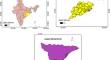
Assessment of land use-land cover dynamics and its future projection through Google Earth Engine, machine learning and QGIS-MOLUSCE: A case study in Jagatsinghpur district, Odisha, India
{"title":"Assessment of land use-land cover dynamics and its future projection through Google Earth Engine, machine learning and QGIS-MOLUSCE: A case study in Jagatsinghpur district, Odisha, India","authors":"Kavita Devanand Bathe, Nita Sanjay Patil","doi":"10.1007/s12040-024-02305-3","DOIUrl":null,"url":null,"abstract":"<p>Accurate land use-land cover mapping is essential to policymakers for future planning. This study aims to assess the land use-land cover dynamics and estimate its future projection in the Jagatsinghpur district of Odisha state from India. In recent years, cloud-based platforms like Google Earth Engine and domains like machine learning have attracted considerable attention from researchers. In this study, five machine learning algorithms, such as Classification and Regression Tree, Naive Bayes, Support Vector Machine, Gradient Tree Boost and Random Forest are experimented on the multitemporal Sentinel-1 C-band dataset from Google Earth Engine. The results are evaluated based on metrics like overall accuracy and Kappa statistics. The performance metrics indicate that Random Forest with 60 trees outperforms others. Next, the land use-land cover maps of the study area are generated with Random Forest classifier for the years 2017 and 2021. The results are compared to ESRI land cover maps and ESA world cover maps. The 2017 and 2021 maps are exported to QGIS, and these maps are used to generate a simulation map for 2021. The simulated land use-land cover map for 2021 indicates promising results with an overall Kappa value of 0.97 and a percentage of correctness of 98.21%. The simulated map is validated against a factual map. Finally, future projections of land-use changes are forecasted for the years 2030 and 2050 using QGIS-MOLUSCE. The predicted maps project a significant rise in agricultural and built-up areas. These findings will assist policymakers in future planning.</p>","PeriodicalId":15609,"journal":{"name":"Journal of Earth System Science","volume":"67 1","pages":""},"PeriodicalIF":1.7000,"publicationDate":"2024-06-05","publicationTypes":"Journal Article","fieldsOfStudy":null,"isOpenAccess":false,"openAccessPdf":"","citationCount":"0","resultStr":null,"platform":"Semanticscholar","paperid":null,"PeriodicalName":"Journal of Earth System Science","FirstCategoryId":"89","ListUrlMain":"https://doi.org/10.1007/s12040-024-02305-3","RegionNum":4,"RegionCategory":"地球科学","ArticlePicture":[],"TitleCN":null,"AbstractTextCN":null,"PMCID":null,"EPubDate":"","PubModel":"","JCR":"Q3","JCRName":"GEOSCIENCES, MULTIDISCIPLINARY","Score":null,"Total":0}
引用次数: 0
Abstract
Accurate land use-land cover mapping is essential to policymakers for future planning. This study aims to assess the land use-land cover dynamics and estimate its future projection in the Jagatsinghpur district of Odisha state from India. In recent years, cloud-based platforms like Google Earth Engine and domains like machine learning have attracted considerable attention from researchers. In this study, five machine learning algorithms, such as Classification and Regression Tree, Naive Bayes, Support Vector Machine, Gradient Tree Boost and Random Forest are experimented on the multitemporal Sentinel-1 C-band dataset from Google Earth Engine. The results are evaluated based on metrics like overall accuracy and Kappa statistics. The performance metrics indicate that Random Forest with 60 trees outperforms others. Next, the land use-land cover maps of the study area are generated with Random Forest classifier for the years 2017 and 2021. The results are compared to ESRI land cover maps and ESA world cover maps. The 2017 and 2021 maps are exported to QGIS, and these maps are used to generate a simulation map for 2021. The simulated land use-land cover map for 2021 indicates promising results with an overall Kappa value of 0.97 and a percentage of correctness of 98.21%. The simulated map is validated against a factual map. Finally, future projections of land-use changes are forecasted for the years 2030 and 2050 using QGIS-MOLUSCE. The predicted maps project a significant rise in agricultural and built-up areas. These findings will assist policymakers in future planning.
期刊介绍:
The Journal of Earth System Science, an International Journal, was earlier a part of the Proceedings of the Indian Academy of Sciences – Section A begun in 1934, and later split in 1978 into theme journals. This journal was published as Proceedings – Earth and Planetary Sciences since 1978, and in 2005 was renamed ‘Journal of Earth System Science’.
The journal is highly inter-disciplinary and publishes scholarly research – new data, ideas, and conceptual advances – in Earth System Science. The focus is on the evolution of the Earth as a system: manuscripts describing changes of anthropogenic origin in a limited region are not considered unless they go beyond describing the changes to include an analysis of earth-system processes. The journal''s scope includes the solid earth (geosphere), the atmosphere, the hydrosphere (including cryosphere), and the biosphere; it also addresses related aspects of planetary and space sciences. Contributions pertaining to the Indian sub- continent and the surrounding Indian-Ocean region are particularly welcome. Given that a large number of manuscripts report either observations or model results for a limited domain, manuscripts intended for publication in JESS are expected to fulfill at least one of the following three criteria.
The data should be of relevance and should be of statistically significant size and from a region from where such data are sparse. If the data are from a well-sampled region, the data size should be considerable and advance our knowledge of the region.
A model study is carried out to explain observations reported either in the same manuscript or in the literature.
The analysis, whether of data or with models, is novel and the inferences advance the current knowledge.
 求助内容:
求助内容: 应助结果提醒方式:


