Cumulative sedimentation hazard map of urban areas subject to hyperconcentrated flash flood: A case study of Suide County in the Wuding River basin, China
Ruixun Lai, Junhua Li, Ping Wang, Yan Guo, Linjuan Xu, Xiangping Zhang, Min Wang, Xiaoli Zhang
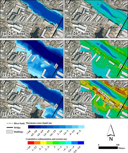
{"title":"Cumulative sedimentation hazard map of urban areas subject to hyperconcentrated flash flood: A case study of Suide County in the Wuding River basin, China","authors":"Ruixun Lai, Junhua Li, Ping Wang, Yan Guo, Linjuan Xu, Xiangping Zhang, Min Wang, Xiaoli Zhang","doi":"10.1111/jfr3.12996","DOIUrl":null,"url":null,"abstract":"<p>Flash floods can carry substantial sediment, posing significant sedimentation hazards in hilly cities. The sedimentation hazard map can reproduce the sediment thickness and extent of an extreme events scenario, playing an important role in sediment risk management. However, current research primarily focuses on modeling the inundation area and depth of floods, while studying sedimentation hazard caused by flash floods in urban areas remains insufficient. This paper aims to address this gap by utilizing a numerical model that simulates hyperconcentrated flow in hilly urban areas using the two-dimensional hydro-sediment-morphological model to compile the cumulative sedimentation hazard map. The model, built upon the open-source TELEMAC-MASCARET framework, incorporates Zhang Hongwu's formula to simulate sediment-carrying capacity, particularly suitable for hyper-sediment concentration near the riverbed. This paper uses the data of extreme flash flood events in the Wuding River basin in 2017 to simulate and compile the cumulative sedimentation hazard map. The hazard map delineates the sedimentation hazard extent and level attributable to overbank floodplain sedimentation. Notably, the sediment thickness is highest in areas near the levees on both sides of the Dali River. Moreover, the map illustrates the extent of channel erosion resulting from hyperconcentrated floods, which could jeopardize bank stability.</p>","PeriodicalId":49294,"journal":{"name":"Journal of Flood Risk Management","volume":"17 3","pages":""},"PeriodicalIF":3.0000,"publicationDate":"2024-05-03","publicationTypes":"Journal Article","fieldsOfStudy":null,"isOpenAccess":false,"openAccessPdf":"https://onlinelibrary.wiley.com/doi/epdf/10.1111/jfr3.12996","citationCount":"0","resultStr":null,"platform":"Semanticscholar","paperid":null,"PeriodicalName":"Journal of Flood Risk Management","FirstCategoryId":"93","ListUrlMain":"https://onlinelibrary.wiley.com/doi/10.1111/jfr3.12996","RegionNum":3,"RegionCategory":"环境科学与生态学","ArticlePicture":[],"TitleCN":null,"AbstractTextCN":null,"PMCID":null,"EPubDate":"","PubModel":"","JCR":"Q2","JCRName":"ENVIRONMENTAL SCIENCES","Score":null,"Total":0}
引用次数: 0
Abstract
Flash floods can carry substantial sediment, posing significant sedimentation hazards in hilly cities. The sedimentation hazard map can reproduce the sediment thickness and extent of an extreme events scenario, playing an important role in sediment risk management. However, current research primarily focuses on modeling the inundation area and depth of floods, while studying sedimentation hazard caused by flash floods in urban areas remains insufficient. This paper aims to address this gap by utilizing a numerical model that simulates hyperconcentrated flow in hilly urban areas using the two-dimensional hydro-sediment-morphological model to compile the cumulative sedimentation hazard map. The model, built upon the open-source TELEMAC-MASCARET framework, incorporates Zhang Hongwu's formula to simulate sediment-carrying capacity, particularly suitable for hyper-sediment concentration near the riverbed. This paper uses the data of extreme flash flood events in the Wuding River basin in 2017 to simulate and compile the cumulative sedimentation hazard map. The hazard map delineates the sedimentation hazard extent and level attributable to overbank floodplain sedimentation. Notably, the sediment thickness is highest in areas near the levees on both sides of the Dali River. Moreover, the map illustrates the extent of channel erosion resulting from hyperconcentrated floods, which could jeopardize bank stability.
期刊介绍:
Journal of Flood Risk Management provides an international platform for knowledge sharing in all areas related to flood risk. Its explicit aim is to disseminate ideas across the range of disciplines where flood related research is carried out and it provides content ranging from leading edge academic papers to applied content with the practitioner in mind.
Readers and authors come from a wide background and include hydrologists, meteorologists, geographers, geomorphologists, conservationists, civil engineers, social scientists, policy makers, insurers and practitioners. They share an interest in managing the complex interactions between the many skills and disciplines that underpin the management of flood risk across the world.

 求助内容:
求助内容: 应助结果提醒方式:


