{"title":"Spatial Distribution and Variation Characteristics of Saturated Hydrologic Conductivity on the Chinese Loess Plateau","authors":"Y. Yang, H. K. Yan, W. H. Tao, L. J. Su","doi":"10.1134/s1064229323603475","DOIUrl":null,"url":null,"abstract":"<h3 data-test=\"abstract-sub-heading\">Abstract</h3><p>The Chinese Loess Plateau (CLP) plays a vital role as an ecological barrier in maintaining the hydrological and climatic conditions of the Yellow River Basin, preventing desertification, and preserving biodiversity. Conducting a systematic analysis and assessment of the saturated hydrological conductivity (<i>K</i><sub>sat</sub>) on the Loess Plateau is crucial for modeling and simulating processes like surface runoff and solute migration. However, due to the uncertainty in detecting the saturated hydraulic conductivity, there are very few regional spatial analyses of the saturated hydraulic conductivity of the CLP. The research results show that the Campbell model is more suitable for the CLP than others. Spatially, <i>K</i><sub>sat</sub> gradually decreases from northwest to southeast. The <i>K</i><sub>sat</sub> in the surface layer (0 cm) was significantly larger than that at the lower soil depths, and the <i>K</i><sub>sat</sub> variability of each soil layer was moderate. Moran;s <i>I</i> decreased as the lag distance increased; this indicated a positive spatial correlation between <i>K</i><sub>sat</sub> and the correlation gradually decreasing with distance. The scattered points are mainly located in the first quadrant, so the local spatial auto-correlation characteristics of the <i>K</i><sub>sat</sub> in this area are clustered with high values. The <i>K</i><sub>sat</sub> for different land cover on the CLP increases in the order grassland > forest land > agricultural land and increases with elevation. This study improves our understanding of land resources and ecological environment management in the CLP.</p>","PeriodicalId":11892,"journal":{"name":"Eurasian Soil Science","volume":"45 1","pages":""},"PeriodicalIF":1.6000,"publicationDate":"2024-05-13","publicationTypes":"Journal Article","fieldsOfStudy":null,"isOpenAccess":false,"openAccessPdf":"","citationCount":"0","resultStr":null,"platform":"Semanticscholar","paperid":null,"PeriodicalName":"Eurasian Soil Science","FirstCategoryId":"97","ListUrlMain":"https://doi.org/10.1134/s1064229323603475","RegionNum":4,"RegionCategory":"农林科学","ArticlePicture":[],"TitleCN":null,"AbstractTextCN":null,"PMCID":null,"EPubDate":"","PubModel":"","JCR":"Q4","JCRName":"SOIL SCIENCE","Score":null,"Total":0}
引用次数: 0
Abstract
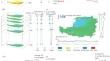
The Chinese Loess Plateau (CLP) plays a vital role as an ecological barrier in maintaining the hydrological and climatic conditions of the Yellow River Basin, preventing desertification, and preserving biodiversity. Conducting a systematic analysis and assessment of the saturated hydrological conductivity (Ksat) on the Loess Plateau is crucial for modeling and simulating processes like surface runoff and solute migration. However, due to the uncertainty in detecting the saturated hydraulic conductivity, there are very few regional spatial analyses of the saturated hydraulic conductivity of the CLP. The research results show that the Campbell model is more suitable for the CLP than others. Spatially, Ksat gradually decreases from northwest to southeast. The Ksat in the surface layer (0 cm) was significantly larger than that at the lower soil depths, and the Ksat variability of each soil layer was moderate. Moran;s I decreased as the lag distance increased; this indicated a positive spatial correlation between Ksat and the correlation gradually decreasing with distance. The scattered points are mainly located in the first quadrant, so the local spatial auto-correlation characteristics of the Ksat in this area are clustered with high values. The Ksat for different land cover on the CLP increases in the order grassland > forest land > agricultural land and increases with elevation. This study improves our understanding of land resources and ecological environment management in the CLP.
期刊介绍:
Eurasian Soil Science publishes original research papers on global and regional studies discussing both theoretical and experimental problems of genesis, geography, physics, chemistry, biology, fertility, management, conservation, and remediation of soils. Special sections are devoted to current news in the life of the International and Russian soil science societies and to the history of soil sciences.
Since 2000, the journal Agricultural Chemistry, the English version of the journal of the Russian Academy of Sciences Agrokhimiya, has been merged into the journal Eurasian Soil Science and is no longer published as a separate title.
 求助内容:
求助内容: 应助结果提醒方式:


