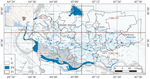
{"title":"Hayfield Mapping in the Floodplain Landscapes of Southern Russia Based on Multitemporal Sentinel-2 Data","authors":"A. A. Vasilchenko","doi":"10.1134/s000143382312023x","DOIUrl":null,"url":null,"abstract":"<h3 data-test=\"abstract-sub-heading\">Abstract</h3><p>This paper proposes a new method for mapping hayfields in floodplain landscapes based on the use of multitemporal spectral–zonal data of earth remote sensing (ERS) of high spatial resolution (Sentinel-2) using an expert threshold of spectral brightness coefficient (SBC) in the red channel (the maximum composite of values for the vegetation period) for freshly cut vegetation adjusted for the values of the maximum composite for the growing season of the normalized difference vegetation index (NDVI). The regularities of changes in the values of SBC in the sloping and nonsloped territories in the RGB and NIR channels, as well as the values of the NDVI and NDWI indices, are revealed. Annual sloping areas within the Volga-Akhtuba floodplain (VAF) in Volgograd oblast are mapped. Here, an average of 12 000 ha (8%) of the territory is mowed annually, while most of the area is mowed in August–September (more than 65% of the area). Most sloping areas are 1 to 10 ha. At the same time, over the past 6 years, there has been a tendency toward an increase in both the total annual mowed areas and the areas of hayfields. It is revealed that the main annually mowed areas are concentrated around infrastructure facilities: closer to consumers and transport routes.</p>","PeriodicalId":54911,"journal":{"name":"Izvestiya Atmospheric and Oceanic Physics","volume":"47 1","pages":""},"PeriodicalIF":0.6000,"publicationDate":"2024-02-20","publicationTypes":"Journal Article","fieldsOfStudy":null,"isOpenAccess":false,"openAccessPdf":"","citationCount":"0","resultStr":null,"platform":"Semanticscholar","paperid":null,"PeriodicalName":"Izvestiya Atmospheric and Oceanic Physics","FirstCategoryId":"89","ListUrlMain":"https://doi.org/10.1134/s000143382312023x","RegionNum":4,"RegionCategory":"地球科学","ArticlePicture":[],"TitleCN":null,"AbstractTextCN":null,"PMCID":null,"EPubDate":"","PubModel":"","JCR":"Q4","JCRName":"METEOROLOGY & ATMOSPHERIC SCIENCES","Score":null,"Total":0}
引用次数: 0
Abstract
This paper proposes a new method for mapping hayfields in floodplain landscapes based on the use of multitemporal spectral–zonal data of earth remote sensing (ERS) of high spatial resolution (Sentinel-2) using an expert threshold of spectral brightness coefficient (SBC) in the red channel (the maximum composite of values for the vegetation period) for freshly cut vegetation adjusted for the values of the maximum composite for the growing season of the normalized difference vegetation index (NDVI). The regularities of changes in the values of SBC in the sloping and nonsloped territories in the RGB and NIR channels, as well as the values of the NDVI and NDWI indices, are revealed. Annual sloping areas within the Volga-Akhtuba floodplain (VAF) in Volgograd oblast are mapped. Here, an average of 12 000 ha (8%) of the territory is mowed annually, while most of the area is mowed in August–September (more than 65% of the area). Most sloping areas are 1 to 10 ha. At the same time, over the past 6 years, there has been a tendency toward an increase in both the total annual mowed areas and the areas of hayfields. It is revealed that the main annually mowed areas are concentrated around infrastructure facilities: closer to consumers and transport routes.
期刊介绍:
Izvestiya, Atmospheric and Oceanic Physics is a journal that publishes original scientific research and review articles on vital issues in the physics of the Earth’s atmosphere and hydrosphere and climate theory. The journal presents results of recent studies of physical processes in the atmosphere and ocean that control climate, weather, and their changes. These studies have possible practical applications. The journal also gives room to the discussion of results obtained in theoretical and experimental studies in various fields of oceanic and atmospheric physics, such as the dynamics of gas and water media, interaction of the atmosphere with the ocean and land surfaces, turbulence theory, heat balance and radiation processes, remote sensing and optics of both media, natural and man-induced climate changes, and the state of the atmosphere and ocean. The journal publishes papers on research techniques used in both media, current scientific information on domestic and foreign events in the physics of the atmosphere and ocean.
 求助内容:
求助内容: 应助结果提醒方式:


