D. V. Khlebnikov, A. Yu. Ivanov, M. A. Evdoshenko, S. K. Klimenko
{"title":"Manifestation of Upwellings in the Black Sea in Multisensor Remote Sensing Data","authors":"D. V. Khlebnikov, A. Yu. Ivanov, M. A. Evdoshenko, S. K. Klimenko","doi":"10.1134/s0001433823120137","DOIUrl":null,"url":null,"abstract":"<h3 data-test=\"abstract-sub-heading\">Abstract</h3><p>Results of upwelling research in the Black Sea, namely in the northeastern part of the sea, near the Tendrovskaya Spit and western coast of Crimea, and off the coast of Turkey, are presented. The results are based on the use of Earth remote sensing data, in particular the data from color scanners (MODIS, VIIRS, OLCI-A, and OLCI-B), infrared radiometers (TIRS and AVHRR), and SAR images from synthetic aperture radars. An integrated approach using almost exclusively remote sensing data makes it possible to fully characterize the observed upwellings in the Black Sea. In the active phase, upwelling, in addition to sea surface temperature (SST), is usually reflected in both the chlorophyll <i>a</i> (Chl <i>a</i>) concentration field and sea surface roughness field. In our cases, the duration of upwellings varied from 6 to 10 days; the SST differences in the upwelling zone reached 3–8°C; and Chl <i>a</i> concentrations were 5–6 times higher than the background values, being 0.5–0.7 mg/m<sup>3</sup>. The maximum SST anomalies up to 8°C were observed off the Turkish coast. The analysis revealed a clear relationship between areas of reduced SST in the upwelling zone, sea surface roughness, and Chl <i>a</i> concentration. It is shown that, in the case of using a complete set of remote sensing data, observing, monitoring, and studying upwelling does not present any fundamental difficulties.</p>","PeriodicalId":54911,"journal":{"name":"Izvestiya Atmospheric and Oceanic Physics","volume":"62 1","pages":""},"PeriodicalIF":0.6000,"publicationDate":"2024-02-20","publicationTypes":"Journal Article","fieldsOfStudy":null,"isOpenAccess":false,"openAccessPdf":"","citationCount":"0","resultStr":null,"platform":"Semanticscholar","paperid":null,"PeriodicalName":"Izvestiya Atmospheric and Oceanic Physics","FirstCategoryId":"89","ListUrlMain":"https://doi.org/10.1134/s0001433823120137","RegionNum":4,"RegionCategory":"地球科学","ArticlePicture":[],"TitleCN":null,"AbstractTextCN":null,"PMCID":null,"EPubDate":"","PubModel":"","JCR":"Q4","JCRName":"METEOROLOGY & ATMOSPHERIC SCIENCES","Score":null,"Total":0}
引用次数: 0
Abstract
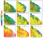
Results of upwelling research in the Black Sea, namely in the northeastern part of the sea, near the Tendrovskaya Spit and western coast of Crimea, and off the coast of Turkey, are presented. The results are based on the use of Earth remote sensing data, in particular the data from color scanners (MODIS, VIIRS, OLCI-A, and OLCI-B), infrared radiometers (TIRS and AVHRR), and SAR images from synthetic aperture radars. An integrated approach using almost exclusively remote sensing data makes it possible to fully characterize the observed upwellings in the Black Sea. In the active phase, upwelling, in addition to sea surface temperature (SST), is usually reflected in both the chlorophyll a (Chl a) concentration field and sea surface roughness field. In our cases, the duration of upwellings varied from 6 to 10 days; the SST differences in the upwelling zone reached 3–8°C; and Chl a concentrations were 5–6 times higher than the background values, being 0.5–0.7 mg/m3. The maximum SST anomalies up to 8°C were observed off the Turkish coast. The analysis revealed a clear relationship between areas of reduced SST in the upwelling zone, sea surface roughness, and Chl a concentration. It is shown that, in the case of using a complete set of remote sensing data, observing, monitoring, and studying upwelling does not present any fundamental difficulties.
期刊介绍:
Izvestiya, Atmospheric and Oceanic Physics is a journal that publishes original scientific research and review articles on vital issues in the physics of the Earth’s atmosphere and hydrosphere and climate theory. The journal presents results of recent studies of physical processes in the atmosphere and ocean that control climate, weather, and their changes. These studies have possible practical applications. The journal also gives room to the discussion of results obtained in theoretical and experimental studies in various fields of oceanic and atmospheric physics, such as the dynamics of gas and water media, interaction of the atmosphere with the ocean and land surfaces, turbulence theory, heat balance and radiation processes, remote sensing and optics of both media, natural and man-induced climate changes, and the state of the atmosphere and ocean. The journal publishes papers on research techniques used in both media, current scientific information on domestic and foreign events in the physics of the atmosphere and ocean.
 求助内容:
求助内容: 应助结果提醒方式:


