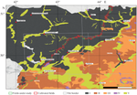
{"title":"Geoinformation Analysis of the Impact of State Protective Forest Belts on the Productivity of Agricultural Land","authors":"A. A. Vypritskiy, V. G. Yuferev","doi":"10.1134/s0001433823120241","DOIUrl":null,"url":null,"abstract":"<h3 data-test=\"abstract-sub-heading\">Abstract—</h3><p>Determining the patterns of changes in the productivity of agricultural land in different growing areas in the zone of influence of State Protective Forest Belts (SPFB) is relevant due to the need to assess the future crop yield in fields with differences in geomorphological, soil, and climatic conditions in the research area. The object was to study the sowing of winter grain crops in fields mixed within the influence of State Protective Forest Belts. Materials and methods involved a research methodology based on the geoinformation analysis of the results of the decryption of actual satellite images, both to identify the distribution of cultivated fields located in the zone of influence of SPFB, and the state of crops on them. At the same time, the soil zonality of the research area was taken into account in view of the considerable length of forest strips. The assessment of the condition of winter grain crops as they move away from the planting was carried out using the NDVI vegetation index calculated from the high-resolution spectral channels of satellite images. Results and conclusions: based on the results of the research, a database of spatial data of the processed fields has been compiled. The grouping of fields was carried out both according to the similarity of the conditions of the places of cultivation of crops and by agricultural crops. Their placement and geomorphological parameters have been established. With the use of geoinformation technologies for groups of fields using statistical processing tools, the average values of the width and area of the selected zones of influence, as well as terrain parameters, were determined. During geoinformation mapping, data on the state of crops at the end of May were obtained based on the change in the NDVI index by field groupings in the zone of SPFB impact. These data are the basis for the forecast of crop yields, taking into account the spatial location of fields.</p>","PeriodicalId":54911,"journal":{"name":"Izvestiya Atmospheric and Oceanic Physics","volume":"51 1","pages":""},"PeriodicalIF":0.6000,"publicationDate":"2024-02-20","publicationTypes":"Journal Article","fieldsOfStudy":null,"isOpenAccess":false,"openAccessPdf":"","citationCount":"0","resultStr":null,"platform":"Semanticscholar","paperid":null,"PeriodicalName":"Izvestiya Atmospheric and Oceanic Physics","FirstCategoryId":"89","ListUrlMain":"https://doi.org/10.1134/s0001433823120241","RegionNum":4,"RegionCategory":"地球科学","ArticlePicture":[],"TitleCN":null,"AbstractTextCN":null,"PMCID":null,"EPubDate":"","PubModel":"","JCR":"Q4","JCRName":"METEOROLOGY & ATMOSPHERIC SCIENCES","Score":null,"Total":0}
引用次数: 0
Abstract
Abstract—
Determining the patterns of changes in the productivity of agricultural land in different growing areas in the zone of influence of State Protective Forest Belts (SPFB) is relevant due to the need to assess the future crop yield in fields with differences in geomorphological, soil, and climatic conditions in the research area. The object was to study the sowing of winter grain crops in fields mixed within the influence of State Protective Forest Belts. Materials and methods involved a research methodology based on the geoinformation analysis of the results of the decryption of actual satellite images, both to identify the distribution of cultivated fields located in the zone of influence of SPFB, and the state of crops on them. At the same time, the soil zonality of the research area was taken into account in view of the considerable length of forest strips. The assessment of the condition of winter grain crops as they move away from the planting was carried out using the NDVI vegetation index calculated from the high-resolution spectral channels of satellite images. Results and conclusions: based on the results of the research, a database of spatial data of the processed fields has been compiled. The grouping of fields was carried out both according to the similarity of the conditions of the places of cultivation of crops and by agricultural crops. Their placement and geomorphological parameters have been established. With the use of geoinformation technologies for groups of fields using statistical processing tools, the average values of the width and area of the selected zones of influence, as well as terrain parameters, were determined. During geoinformation mapping, data on the state of crops at the end of May were obtained based on the change in the NDVI index by field groupings in the zone of SPFB impact. These data are the basis for the forecast of crop yields, taking into account the spatial location of fields.
期刊介绍:
Izvestiya, Atmospheric and Oceanic Physics is a journal that publishes original scientific research and review articles on vital issues in the physics of the Earth’s atmosphere and hydrosphere and climate theory. The journal presents results of recent studies of physical processes in the atmosphere and ocean that control climate, weather, and their changes. These studies have possible practical applications. The journal also gives room to the discussion of results obtained in theoretical and experimental studies in various fields of oceanic and atmospheric physics, such as the dynamics of gas and water media, interaction of the atmosphere with the ocean and land surfaces, turbulence theory, heat balance and radiation processes, remote sensing and optics of both media, natural and man-induced climate changes, and the state of the atmosphere and ocean. The journal publishes papers on research techniques used in both media, current scientific information on domestic and foreign events in the physics of the atmosphere and ocean.
 求助内容:
求助内容: 应助结果提醒方式:


