{"title":"GNSS Gravity Leveling","authors":"Hurong Duan, Yerui Zhang, Lelin Xing, Weifeng Liang","doi":"10.1007/s00024-024-03492-2","DOIUrl":null,"url":null,"abstract":"<p>A new method of GNSS gravity leveling is introduced to determine precisely normal height differences, Both the principle and application of the method are elaborated. Leveling surveying, gravity measurements, and GNSS measurements are carried out in a special region (including slopes, valleys and mountain ridges) to verify its accuracy by combining with gravity potential model. The results show that the precision by this method is mainly influenced by ellipsoidal height differences, gravity potential models, and gravity observations. However, the error by this method exhibits a clear linear relationship with the height difference, while it is independent of the length of the survey line. Within a specific range of height differences (within 360 m), the precision of the GNSS gravity leveling can reach the level of ± 10 mm. This method can, to some extent, provides a modern solution for height measurement which can replace the high-precision leveling surveying. The advantages of GNSS gravity leveling include high precision and high efficiency. It has a promising application prospect in geodesy, hydraulic engineering, earthquake and volcano monitoring.</p>","PeriodicalId":21078,"journal":{"name":"pure and applied geophysics","volume":"2015 1","pages":""},"PeriodicalIF":1.9000,"publicationDate":"2024-04-26","publicationTypes":"Journal Article","fieldsOfStudy":null,"isOpenAccess":false,"openAccessPdf":"","citationCount":"0","resultStr":null,"platform":"Semanticscholar","paperid":null,"PeriodicalName":"pure and applied geophysics","FirstCategoryId":"89","ListUrlMain":"https://doi.org/10.1007/s00024-024-03492-2","RegionNum":4,"RegionCategory":"地球科学","ArticlePicture":[],"TitleCN":null,"AbstractTextCN":null,"PMCID":null,"EPubDate":"","PubModel":"","JCR":"Q2","JCRName":"GEOCHEMISTRY & GEOPHYSICS","Score":null,"Total":0}
引用次数: 0
Abstract
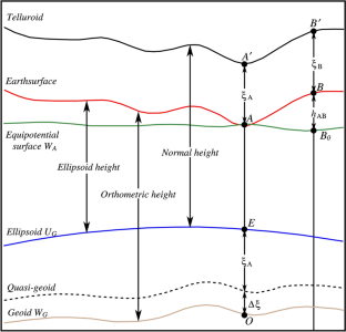
A new method of GNSS gravity leveling is introduced to determine precisely normal height differences, Both the principle and application of the method are elaborated. Leveling surveying, gravity measurements, and GNSS measurements are carried out in a special region (including slopes, valleys and mountain ridges) to verify its accuracy by combining with gravity potential model. The results show that the precision by this method is mainly influenced by ellipsoidal height differences, gravity potential models, and gravity observations. However, the error by this method exhibits a clear linear relationship with the height difference, while it is independent of the length of the survey line. Within a specific range of height differences (within 360 m), the precision of the GNSS gravity leveling can reach the level of ± 10 mm. This method can, to some extent, provides a modern solution for height measurement which can replace the high-precision leveling surveying. The advantages of GNSS gravity leveling include high precision and high efficiency. It has a promising application prospect in geodesy, hydraulic engineering, earthquake and volcano monitoring.
期刊介绍:
pure and applied geophysics (pageoph), a continuation of the journal "Geofisica pura e applicata", publishes original scientific contributions in the fields of solid Earth, atmospheric and oceanic sciences. Regular and special issues feature thought-provoking reports on active areas of current research and state-of-the-art surveys.
Long running journal, founded in 1939 as Geofisica pura e applicata
Publishes peer-reviewed original scientific contributions and state-of-the-art surveys in solid earth and atmospheric sciences
Features thought-provoking reports on active areas of current research and is a major source for publications on tsunami research
Coverage extends to research topics in oceanic sciences
See Instructions for Authors on the right hand side.
 求助内容:
求助内容: 应助结果提醒方式:


