Mechanical Essence of Double-Arc Formation Along the Eastern Aleutian Subduction Zone

IF 1.9 4区 地球科学 Q2 GEOCHEMISTRY & GEOPHYSICS
Chihiro Hashimoto, Suguru Kuroiwa
{"title":"Mechanical Essence of Double-Arc Formation Along the Eastern Aleutian Subduction Zone","authors":"Chihiro Hashimoto,&nbsp;Suguru Kuroiwa","doi":"10.1007/s00024-024-03470-8","DOIUrl":null,"url":null,"abstract":"<div><p>The free-air gravity anomaly along the Aleutian subduction zone exhibits a single set of negative and positive trench-parallel belts in the western region, whereas it exhibits doubled negative–positive trench-parallel belts in the eastern region. The eastern inner–western positive gravitational belt corresponds to the topographic chain of the Alaska Peninsula and the Aleutian Islands. However, the eastern outer positive gravitational belt does not coincide with the chain of the topographic outer-arc highs. In this study, we determined the across-trench profiles of the plate interface geometry for the western and eastern Aleutian subduction zones on the basis of the hypocentre distribution. The surface uplift rates computed from the dislocation-based two-dimensional subduction model for the Aleutian plate interface profiles adequately reproduced the western single-arc and eastern double-arc characteristics. The essential factors of the double-arc formation are a low subduction dip angle and a bimodal plate interface curvature distribution within the elastic lithosphere. The double-arc highs of the computed uplift rates more closely coincided with the gravitational highs than the current topographic highs. This implies that tectonic events in the past caused the topographic activity shift towards the continental shelf edge and the subsequent topographic readjustment under the current tectonic state.</p></div>","PeriodicalId":21078,"journal":{"name":"pure and applied geophysics","volume":"181 5","pages":"1509 - 1521"},"PeriodicalIF":1.9000,"publicationDate":"2024-04-17","publicationTypes":"Journal Article","fieldsOfStudy":null,"isOpenAccess":false,"openAccessPdf":"https://link.springer.com/content/pdf/10.1007/s00024-024-03470-8.pdf","citationCount":"0","resultStr":null,"platform":"Semanticscholar","paperid":null,"PeriodicalName":"pure and applied geophysics","FirstCategoryId":"89","ListUrlMain":"https://link.springer.com/article/10.1007/s00024-024-03470-8","RegionNum":4,"RegionCategory":"地球科学","ArticlePicture":[],"TitleCN":null,"AbstractTextCN":null,"PMCID":null,"EPubDate":"","PubModel":"","JCR":"Q2","JCRName":"GEOCHEMISTRY & GEOPHYSICS","Score":null,"Total":0}
引用次数: 0

Abstract

The free-air gravity anomaly along the Aleutian subduction zone exhibits a single set of negative and positive trench-parallel belts in the western region, whereas it exhibits doubled negative–positive trench-parallel belts in the eastern region. The eastern inner–western positive gravitational belt corresponds to the topographic chain of the Alaska Peninsula and the Aleutian Islands. However, the eastern outer positive gravitational belt does not coincide with the chain of the topographic outer-arc highs. In this study, we determined the across-trench profiles of the plate interface geometry for the western and eastern Aleutian subduction zones on the basis of the hypocentre distribution. The surface uplift rates computed from the dislocation-based two-dimensional subduction model for the Aleutian plate interface profiles adequately reproduced the western single-arc and eastern double-arc characteristics. The essential factors of the double-arc formation are a low subduction dip angle and a bimodal plate interface curvature distribution within the elastic lithosphere. The double-arc highs of the computed uplift rates more closely coincided with the gravitational highs than the current topographic highs. This implies that tectonic events in the past caused the topographic activity shift towards the continental shelf edge and the subsequent topographic readjustment under the current tectonic state.
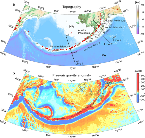
Abstract Image

东阿留申俯冲带双弧形成的力学本质
阿留申俯冲带沿线的自由空气重力异常在西部地区表现为单组负向和正向海沟平行带,而在东部地区则表现为双组负向和正向海沟平行带。东部内-西部正引力带与阿拉斯加半岛和阿留申群岛的地形链相对应。然而,东部外侧正引力带与地形外弧高地链并不吻合。在本研究中,我们根据次中心分布确定了阿留申俯冲带西部和东部板块界面几何的跨海沟剖面。根据基于位错的二维俯冲模型计算出的阿留申板块界面剖面的地表隆起率充分再现了西部单弧和东部双弧的特征。双弧形成的基本因素是低俯冲倾角和弹性岩石圈内的双峰板块界面曲率分布。计算得出的双弧高点隆升率与重力高点的吻合程度高于当前地形高点。这意味着过去的构造事件导致了地形活动向大陆架边缘的转移,以及随后在当前构造状态下的地形再调整。
本文章由计算机程序翻译,如有差异,请以英文原文为准。
求助全文
约1分钟内获得全文 求助全文
来源期刊
pure and applied geophysics
pure and applied geophysics 地学-地球化学与地球物理
CiteScore
4.20
自引率
5.00%
发文量
240
审稿时长
9.8 months
期刊介绍: pure and applied geophysics (pageoph), a continuation of the journal "Geofisica pura e applicata", publishes original scientific contributions in the fields of solid Earth, atmospheric and oceanic sciences. Regular and special issues feature thought-provoking reports on active areas of current research and state-of-the-art surveys. Long running journal, founded in 1939 as Geofisica pura e applicata Publishes peer-reviewed original scientific contributions and state-of-the-art surveys in solid earth and atmospheric sciences Features thought-provoking reports on active areas of current research and is a major source for publications on tsunami research Coverage extends to research topics in oceanic sciences See Instructions for Authors on the right hand side.
×
引用
GB/T 7714-2015
复制
MLA
复制
APA
复制
导出至
BibTeX EndNote RefMan NoteFirst NoteExpress
×
提示
您的信息不完整,为了账户安全,请先补充。
现在去补充
×
提示
您因"违规操作"
具体请查看互助需知
我知道了
×
提示
确定
请完成安全验证×
copy
已复制链接
快去分享给好友吧!
我知道了
右上角分享
点击右上角分享
0
联系我们:info@booksci.cn Book学术提供免费学术资源搜索服务,方便国内外学者检索中英文文献。致力于提供最便捷和优质的服务体验。 Copyright © 2023 布克学术 All rights reserved.
京ICP备2023020795号-1
ghs 京公网安备 11010802042870号
Book学术文献互助
Book学术文献互助群
群 号:481959085
Book学术官方微信