{"title":"How far will you go? From empirical findings to formalization of walking route distances","authors":"Jonatan Almagor , Itzhak Omer , Noam Omer , Amit Birenboim","doi":"10.1016/j.compenvurbsys.2024.102117","DOIUrl":null,"url":null,"abstract":"<div><p>Empirically based theorization of walking range patterns is rather limited, leading researchers and planners to rely on simplistic assumptions as to the typical distance and duration that pedestrians may walk. Using high-resolution GPS data collected from over 11,000 participants in the Tel-Aviv metropolitan area, we provide an empirical estimate for the distribution of walking route distance and duration, while examining potential factors that may affect it. In addition, we develop a general analytical framework that describes walking route patterns. Our results show that the average route distance and duration in Tel-Aviv metropolitan is 630 m and 7.9 min. Factors associated with walking range include socio-demographic characteristics of walkers (age-group, socioeconomic status and number of cars in a household) and city characteristics (longer routes in cities with a larger population and in areas with high density of street intersections). Our main finding is that walking route distance distribution can be best described using the theoretical log-normal distribution and can be characterized using its mean-log and SD-log parameters. The log-normal parameters make an analytical framework that enables the evaluation of differences in walking patterns between places and identification of where interventions are required to promote active travel. We explain why the log-normal distribution is likely to be suitable to other cases worldwide.</p></div>","PeriodicalId":48241,"journal":{"name":"Computers Environment and Urban Systems","volume":"110 ","pages":"Article 102117"},"PeriodicalIF":7.1000,"publicationDate":"2024-04-16","publicationTypes":"Journal Article","fieldsOfStudy":null,"isOpenAccess":false,"openAccessPdf":"","citationCount":"0","resultStr":null,"platform":"Semanticscholar","paperid":null,"PeriodicalName":"Computers Environment and Urban Systems","FirstCategoryId":"89","ListUrlMain":"https://www.sciencedirect.com/science/article/pii/S0198971524000462","RegionNum":1,"RegionCategory":"地球科学","ArticlePicture":[],"TitleCN":null,"AbstractTextCN":null,"PMCID":null,"EPubDate":"","PubModel":"","JCR":"Q1","JCRName":"ENVIRONMENTAL STUDIES","Score":null,"Total":0}
引用次数: 0
Abstract
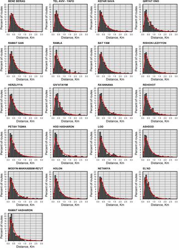
Empirically based theorization of walking range patterns is rather limited, leading researchers and planners to rely on simplistic assumptions as to the typical distance and duration that pedestrians may walk. Using high-resolution GPS data collected from over 11,000 participants in the Tel-Aviv metropolitan area, we provide an empirical estimate for the distribution of walking route distance and duration, while examining potential factors that may affect it. In addition, we develop a general analytical framework that describes walking route patterns. Our results show that the average route distance and duration in Tel-Aviv metropolitan is 630 m and 7.9 min. Factors associated with walking range include socio-demographic characteristics of walkers (age-group, socioeconomic status and number of cars in a household) and city characteristics (longer routes in cities with a larger population and in areas with high density of street intersections). Our main finding is that walking route distance distribution can be best described using the theoretical log-normal distribution and can be characterized using its mean-log and SD-log parameters. The log-normal parameters make an analytical framework that enables the evaluation of differences in walking patterns between places and identification of where interventions are required to promote active travel. We explain why the log-normal distribution is likely to be suitable to other cases worldwide.
期刊介绍:
Computers, Environment and Urban Systemsis an interdisciplinary journal publishing cutting-edge and innovative computer-based research on environmental and urban systems, that privileges the geospatial perspective. The journal welcomes original high quality scholarship of a theoretical, applied or technological nature, and provides a stimulating presentation of perspectives, research developments, overviews of important new technologies and uses of major computational, information-based, and visualization innovations. Applied and theoretical contributions demonstrate the scope of computer-based analysis fostering a better understanding of environmental and urban systems, their spatial scope and their dynamics.