F. Monger, D. V. Spracklen, M. J. Kirkby, T. Willis
{"title":"Investigating the impact of woodland placement and percentage cover on flood peaks in an upland catchment using spatially distributed TOPMODEL","authors":"F. Monger, D. V. Spracklen, M. J. Kirkby, T. Willis","doi":"10.1111/jfr3.12977","DOIUrl":null,"url":null,"abstract":"<p>Woodlands can reduce downstream flooding, but it is not well known how the extent and distribution of woodland affects reductions in peak flow. We used the spatially distributed TOPMODEL to simulate peak flow during a 1 in 50 year storm event for a range of broadleaf woodland scenarios across a 2.6 km<sup>2</sup> catchment in Northern England. Woodland reduced peak flow by 2.6%–15.3% depending on the extent and spatial distribution of woodland cover. Cross slope and riparian woodland resulted in larger reductions in peak flow, 4.9% and 3.3% for a 10-percentage point increase in woodland cover respectively, compared to a 2.7% reduction for woodland randomly located across the catchment. Our results demonstrate that increased woodland cover can reduce peak flows during a large storm event and suggest that targeted placement of woodland can maximise the effectiveness of natural flood management interventions.</p>","PeriodicalId":49294,"journal":{"name":"Journal of Flood Risk Management","volume":"17 2","pages":""},"PeriodicalIF":3.0000,"publicationDate":"2024-02-27","publicationTypes":"Journal Article","fieldsOfStudy":null,"isOpenAccess":false,"openAccessPdf":"https://onlinelibrary.wiley.com/doi/epdf/10.1111/jfr3.12977","citationCount":"0","resultStr":null,"platform":"Semanticscholar","paperid":null,"PeriodicalName":"Journal of Flood Risk Management","FirstCategoryId":"93","ListUrlMain":"https://onlinelibrary.wiley.com/doi/10.1111/jfr3.12977","RegionNum":3,"RegionCategory":"环境科学与生态学","ArticlePicture":[],"TitleCN":null,"AbstractTextCN":null,"PMCID":null,"EPubDate":"","PubModel":"","JCR":"Q2","JCRName":"ENVIRONMENTAL SCIENCES","Score":null,"Total":0}
引用次数: 0
Abstract
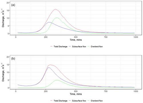
Woodlands can reduce downstream flooding, but it is not well known how the extent and distribution of woodland affects reductions in peak flow. We used the spatially distributed TOPMODEL to simulate peak flow during a 1 in 50 year storm event for a range of broadleaf woodland scenarios across a 2.6 km2 catchment in Northern England. Woodland reduced peak flow by 2.6%–15.3% depending on the extent and spatial distribution of woodland cover. Cross slope and riparian woodland resulted in larger reductions in peak flow, 4.9% and 3.3% for a 10-percentage point increase in woodland cover respectively, compared to a 2.7% reduction for woodland randomly located across the catchment. Our results demonstrate that increased woodland cover can reduce peak flows during a large storm event and suggest that targeted placement of woodland can maximise the effectiveness of natural flood management interventions.
期刊介绍:
Journal of Flood Risk Management provides an international platform for knowledge sharing in all areas related to flood risk. Its explicit aim is to disseminate ideas across the range of disciplines where flood related research is carried out and it provides content ranging from leading edge academic papers to applied content with the practitioner in mind.
Readers and authors come from a wide background and include hydrologists, meteorologists, geographers, geomorphologists, conservationists, civil engineers, social scientists, policy makers, insurers and practitioners. They share an interest in managing the complex interactions between the many skills and disciplines that underpin the management of flood risk across the world.

 求助内容:
求助内容: 应助结果提醒方式:


