{"title":"Landslide susceptibility assessment in sikkim himalaya with rs & gis, augmented by improved statistical methods","authors":"Kuldeep Dutta, Nishchal Wanjari, Anil Kumar Misra","doi":"10.1007/s12517-024-11944-1","DOIUrl":null,"url":null,"abstract":"<p>Landslide susceptibility zonation is a widely studied method for assessing the likelihood of landslides in specific areas. This study focuses on the Ranikhola watershed in the Sikkim Himalaya and utilizes the Frequency Ratio (FR) and Modified Information Value (MIV) methods to analyse landslide susceptibility. To enhance the susceptibility mapping a novel approach for the FR and MIV is introduced where the factor classes of higher importance were utilized. The study further evaluates a methodology that incorporates weighted ranking of landslide conditioning factor classes using FR and MIV indexes to generate landslide susceptibility maps (LSM). The landslide inventory comprises 124 landslides identified through satellite imagery from Q-GIS quick maps, ESRI base map, Google Earth, and Sentinel 2 A & B. Sixteen conditioning factors are considered, including elevation, slope angle, aspect, curvature, drainage characteristics, vegetation index, geology, soil type, rainfall, road density, and land use. The LSI and LSM are derived from these factors. The LSM created using traditional FR and MIV methods show that 9.55% and 5.96% of the watershed area fall within the High Susceptibility Zone (HSZ) and Very High Susceptibility Zone (VHSZ), respectively. However, the novel approach reveals that 11.54% and 10.29% of the study area fall within the HSZ and VHSZ. The weighted ranking method indicates that 16.22% of the Ranikhola watershed area is within the HSZ and VHSZ. The models are evaluated using the area under the receiver operating characteristic curve (AUC), with FR and MIV methods producing AUC values of 0.77 and 0.68, respectively. The new approach improves the AUC of the MIV method to 0.76, while the FR method remains relatively unchanged. The weighting method outperforms other FR and MIV methods, with an AUC of 0.90. Correlation analysis of the condition factors suggests that profile curvature, slope, stream power index, and topographic wetness index are the most influential factors, positively impacting each other and contributing to higher landslide susceptibility. The study emphasizes the importance of incorporating weighted ranking of landslide conditioning factor classes to create LSM, rather than relying on the total landslide susceptibility index (LSI) of factors. The findings provide valuable data for future large-scale investigations and efforts to enhance hazard preparedness in the Ranikhola watershed.</p>","PeriodicalId":476,"journal":{"name":"Arabian Journal of Geosciences","volume":null,"pages":null},"PeriodicalIF":1.8270,"publicationDate":"2024-03-27","publicationTypes":"Journal Article","fieldsOfStudy":null,"isOpenAccess":false,"openAccessPdf":"","citationCount":"0","resultStr":null,"platform":"Semanticscholar","paperid":null,"PeriodicalName":"Arabian Journal of Geosciences","FirstCategoryId":"1085","ListUrlMain":"https://doi.org/10.1007/s12517-024-11944-1","RegionNum":0,"RegionCategory":null,"ArticlePicture":[],"TitleCN":null,"AbstractTextCN":null,"PMCID":null,"EPubDate":"","PubModel":"","JCR":"Q2","JCRName":"Earth and Planetary Sciences","Score":null,"Total":0}
引用次数: 0
Abstract
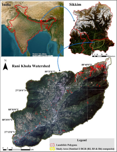
Landslide susceptibility zonation is a widely studied method for assessing the likelihood of landslides in specific areas. This study focuses on the Ranikhola watershed in the Sikkim Himalaya and utilizes the Frequency Ratio (FR) and Modified Information Value (MIV) methods to analyse landslide susceptibility. To enhance the susceptibility mapping a novel approach for the FR and MIV is introduced where the factor classes of higher importance were utilized. The study further evaluates a methodology that incorporates weighted ranking of landslide conditioning factor classes using FR and MIV indexes to generate landslide susceptibility maps (LSM). The landslide inventory comprises 124 landslides identified through satellite imagery from Q-GIS quick maps, ESRI base map, Google Earth, and Sentinel 2 A & B. Sixteen conditioning factors are considered, including elevation, slope angle, aspect, curvature, drainage characteristics, vegetation index, geology, soil type, rainfall, road density, and land use. The LSI and LSM are derived from these factors. The LSM created using traditional FR and MIV methods show that 9.55% and 5.96% of the watershed area fall within the High Susceptibility Zone (HSZ) and Very High Susceptibility Zone (VHSZ), respectively. However, the novel approach reveals that 11.54% and 10.29% of the study area fall within the HSZ and VHSZ. The weighted ranking method indicates that 16.22% of the Ranikhola watershed area is within the HSZ and VHSZ. The models are evaluated using the area under the receiver operating characteristic curve (AUC), with FR and MIV methods producing AUC values of 0.77 and 0.68, respectively. The new approach improves the AUC of the MIV method to 0.76, while the FR method remains relatively unchanged. The weighting method outperforms other FR and MIV methods, with an AUC of 0.90. Correlation analysis of the condition factors suggests that profile curvature, slope, stream power index, and topographic wetness index are the most influential factors, positively impacting each other and contributing to higher landslide susceptibility. The study emphasizes the importance of incorporating weighted ranking of landslide conditioning factor classes to create LSM, rather than relying on the total landslide susceptibility index (LSI) of factors. The findings provide valuable data for future large-scale investigations and efforts to enhance hazard preparedness in the Ranikhola watershed.
期刊介绍:
The Arabian Journal of Geosciences is the official journal of the Saudi Society for Geosciences and publishes peer-reviewed original and review articles on the entire range of Earth Science themes, focused on, but not limited to, those that have regional significance to the Middle East and the Euro-Mediterranean Zone.
Key topics therefore include; geology, hydrogeology, earth system science, petroleum sciences, geophysics, seismology and crustal structures, tectonics, sedimentology, palaeontology, metamorphic and igneous petrology, natural hazards, environmental sciences and sustainable development, geoarchaeology, geomorphology, paleo-environment studies, oceanography, atmospheric sciences, GIS and remote sensing, geodesy, mineralogy, volcanology, geochemistry and metallogenesis.

 求助内容:
求助内容: 应助结果提醒方式:


