Kouayep Lawou Sylvain, Samba Assomo Philippe, Michel Rodrigue Oscar Kenmoe, Bombey Quinta, Kamgang Kabeyene Beyala Veronique
{"title":"Mass movement susceptibility: the case study of Tongo-Gadima landslide, East Cameroon","authors":"Kouayep Lawou Sylvain, Samba Assomo Philippe, Michel Rodrigue Oscar Kenmoe, Bombey Quinta, Kamgang Kabeyene Beyala Veronique","doi":"10.1007/s12517-024-11938-z","DOIUrl":null,"url":null,"abstract":"<p>The causes of mass movement, which occurred on the 5<sup>th</sup> October 2021 at Tongo-Gadima and damage grouting drainage infrastructure of the national road, are examined in this paper, in order to set up the novel procedure for investigating landslide in an area with limited inventory geotechnical data. They are evaluated by estimating the annual precipitation on 12-year period and analyzing the relevant geotechnical parameters: water content, degree of saturation, consistency limits, grain size distribution, linear shear strength, uniaxial compressive strength, compressibility test on samples collected on the field in order to understand the behavior of lateritic soil exposed under rainfall as well as zonation of slopes. This investigation will, in turn, enable the stakeholders to implement appropriate mitigation measures across the landslide-induce area. The main characteristics such as concave slope, shallow slid surface occurrence, and rotational trend of Tongo-Gadima landslide were influenced by high annual rainfall reaching the average of 1540 mm. The zonation analysis identified steeping slope (> 20°) called escarpment landscape. High values of water content and degree of saturation induced the swelling behavior of unsaturated soil. It has high plasticity in the lower and median set made up of more than 30% fine clay. The internal friction angle and material cohesion showed poor characteristic 35° and 0.11 bar respectively. The low uniaxial compressive strength ranging between 1.77 and 7.87 MPa suggests that the complete meteoric weathering of rock and the C<sub>c</sub>/(1 + e<sub>0</sub>) > 0.20 ratio confirms the very compressible property of soil. The evidence of thixotropic rheoliquefier pattern of the clay matric mixed with gravel and sand is detrimental when meteoric water infiltration transforms the material into landslide-prone mud under constraint. Poor drainage has considerably increased water saturation of clay particles in the prism of rupture and weak mechanical properties of soil have been at the origin of landslide in Tongo-Gadima. Instrumentation and monitoring of slope are the first action to be taken to mitigate landslide in the region.</p>","PeriodicalId":476,"journal":{"name":"Arabian Journal of Geosciences","volume":null,"pages":null},"PeriodicalIF":1.8270,"publicationDate":"2024-03-28","publicationTypes":"Journal Article","fieldsOfStudy":null,"isOpenAccess":false,"openAccessPdf":"","citationCount":"0","resultStr":null,"platform":"Semanticscholar","paperid":null,"PeriodicalName":"Arabian Journal of Geosciences","FirstCategoryId":"1085","ListUrlMain":"https://doi.org/10.1007/s12517-024-11938-z","RegionNum":0,"RegionCategory":null,"ArticlePicture":[],"TitleCN":null,"AbstractTextCN":null,"PMCID":null,"EPubDate":"","PubModel":"","JCR":"Q2","JCRName":"Earth and Planetary Sciences","Score":null,"Total":0}
引用次数: 0
Abstract
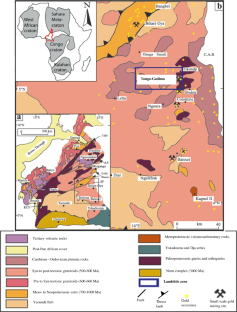
The causes of mass movement, which occurred on the 5th October 2021 at Tongo-Gadima and damage grouting drainage infrastructure of the national road, are examined in this paper, in order to set up the novel procedure for investigating landslide in an area with limited inventory geotechnical data. They are evaluated by estimating the annual precipitation on 12-year period and analyzing the relevant geotechnical parameters: water content, degree of saturation, consistency limits, grain size distribution, linear shear strength, uniaxial compressive strength, compressibility test on samples collected on the field in order to understand the behavior of lateritic soil exposed under rainfall as well as zonation of slopes. This investigation will, in turn, enable the stakeholders to implement appropriate mitigation measures across the landslide-induce area. The main characteristics such as concave slope, shallow slid surface occurrence, and rotational trend of Tongo-Gadima landslide were influenced by high annual rainfall reaching the average of 1540 mm. The zonation analysis identified steeping slope (> 20°) called escarpment landscape. High values of water content and degree of saturation induced the swelling behavior of unsaturated soil. It has high plasticity in the lower and median set made up of more than 30% fine clay. The internal friction angle and material cohesion showed poor characteristic 35° and 0.11 bar respectively. The low uniaxial compressive strength ranging between 1.77 and 7.87 MPa suggests that the complete meteoric weathering of rock and the Cc/(1 + e0) > 0.20 ratio confirms the very compressible property of soil. The evidence of thixotropic rheoliquefier pattern of the clay matric mixed with gravel and sand is detrimental when meteoric water infiltration transforms the material into landslide-prone mud under constraint. Poor drainage has considerably increased water saturation of clay particles in the prism of rupture and weak mechanical properties of soil have been at the origin of landslide in Tongo-Gadima. Instrumentation and monitoring of slope are the first action to be taken to mitigate landslide in the region.
期刊介绍:
The Arabian Journal of Geosciences is the official journal of the Saudi Society for Geosciences and publishes peer-reviewed original and review articles on the entire range of Earth Science themes, focused on, but not limited to, those that have regional significance to the Middle East and the Euro-Mediterranean Zone.
Key topics therefore include; geology, hydrogeology, earth system science, petroleum sciences, geophysics, seismology and crustal structures, tectonics, sedimentology, palaeontology, metamorphic and igneous petrology, natural hazards, environmental sciences and sustainable development, geoarchaeology, geomorphology, paleo-environment studies, oceanography, atmospheric sciences, GIS and remote sensing, geodesy, mineralogy, volcanology, geochemistry and metallogenesis.

 求助内容:
求助内容: 应助结果提醒方式:


