{"title":"Land use land cover simulations using integrated CA-Markov model in the Tawi Basin of Jammu and Kashmir India","authors":"Ajay Kumar Taloor , Savati Sharma , Gurnam Parsad , Rakesh Jasrotia","doi":"10.1016/j.geogeo.2024.100268","DOIUrl":null,"url":null,"abstract":"<div><p>Land use and land cover (LULC) changes are important indicators of environmental and socio-economic changes made by the natural and anthropogenic sources. The present study is based on the Cellular Automata (CA) Markov model for predicting the LULC changes in the Tawi Basin. To decipher the spatio-temporal distributions of LULC, the Landsat images of 2010 and 2020 were used to analyse the LULC classification. Further, CA Markov model simulations of various scenarios of eight decades (2030 to 2100) were generated based on LULC of 2010 and 2020 data to know the LULC perspective changes in the Tawi Basin, which has witnessed the enormous developmental activities such as growth in settlement, population, and agriculture sector over the years. The model predicts that a population explosion leading to rapid urbanization and rural expansions.</p><p>Settlement is expected to increase from 5.29% of the total area in 2020 to 13.975% in the year 2100. The CA–Markov model results paint a picture of significant changes in land use and settlement patterns in the Tawi Basin. The study serves as a crucial tool for guiding future planning efforts, urging environmentalists, planners, and decision-makers to prioritize sustainable practices and make informed decisions for the well-being of the region.</p></div>","PeriodicalId":100582,"journal":{"name":"Geosystems and Geoenvironment","volume":"3 2","pages":"Article 100268"},"PeriodicalIF":0.0000,"publicationDate":"2024-03-08","publicationTypes":"Journal Article","fieldsOfStudy":null,"isOpenAccess":false,"openAccessPdf":"https://www.sciencedirect.com/science/article/pii/S2772883824000189/pdfft?md5=0baede77b32bc585579a10d9eb661a16&pid=1-s2.0-S2772883824000189-main.pdf","citationCount":"0","resultStr":null,"platform":"Semanticscholar","paperid":null,"PeriodicalName":"Geosystems and Geoenvironment","FirstCategoryId":"1085","ListUrlMain":"https://www.sciencedirect.com/science/article/pii/S2772883824000189","RegionNum":0,"RegionCategory":null,"ArticlePicture":[],"TitleCN":null,"AbstractTextCN":null,"PMCID":null,"EPubDate":"","PubModel":"","JCR":"","JCRName":"","Score":null,"Total":0}
引用次数: 0
Abstract
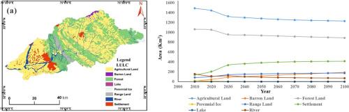
Land use and land cover (LULC) changes are important indicators of environmental and socio-economic changes made by the natural and anthropogenic sources. The present study is based on the Cellular Automata (CA) Markov model for predicting the LULC changes in the Tawi Basin. To decipher the spatio-temporal distributions of LULC, the Landsat images of 2010 and 2020 were used to analyse the LULC classification. Further, CA Markov model simulations of various scenarios of eight decades (2030 to 2100) were generated based on LULC of 2010 and 2020 data to know the LULC perspective changes in the Tawi Basin, which has witnessed the enormous developmental activities such as growth in settlement, population, and agriculture sector over the years. The model predicts that a population explosion leading to rapid urbanization and rural expansions.
Settlement is expected to increase from 5.29% of the total area in 2020 to 13.975% in the year 2100. The CA–Markov model results paint a picture of significant changes in land use and settlement patterns in the Tawi Basin. The study serves as a crucial tool for guiding future planning efforts, urging environmentalists, planners, and decision-makers to prioritize sustainable practices and make informed decisions for the well-being of the region.

 求助内容:
求助内容: 应助结果提醒方式:


