Modern High-Resolution Digital Elevation Model of the Kara Sea Bottom
IF 0.8
4区 地球科学
Q4 OCEANOGRAPHY
引用次数: 0
Abstract
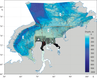
The digital elevation model (DEM) of the Kara Sea bottom was created on the basis of multiscale navigation charts from the Department of Navigation and Oceanography of the Ministry of Defense of the Russian Federation. The errors in the created DEM and publicly available IBCAO v3 DEM were calculated using data obtained during expeditions from 2007 to 2022 in the Kara Sea. The accuracy of these two DEMs was assessed using descriptive statistical methods, demonstrating significantly better seabed relief detail in the created DEM.
喀拉海海底现代高分辨率数字高程模型
摘要 卡拉海海底数字高程模型(DEM)是根据俄罗斯联邦国防部导航和海洋学部的多尺度导航图制作的。利用 2007 年至 2022 年在喀拉海考察期间获得的数据,计算了创建的 DEM 与公开的 IBCAO v3 DEM 之间的误差。使用描述性统计方法评估了这两种 DEM 的准确性,结果表明创建的 DEM 的海底地形细节明显更好。
本文章由计算机程序翻译,如有差异,请以英文原文为准。
求助全文
约1分钟内获得全文
求助全文
来源期刊
Oceanology
地学-海洋学
CiteScore
2.00
自引率
20.00%
发文量
83
审稿时长
6-12 weeks
期刊介绍:
Oceanology, founded in 1961, is the leading journal in all areas of the marine sciences. It publishes original papers in all fields of theoretical and experimental research in physical, chemical, biological, geological, and technical oceanology. The journal also offers reviews and information about conferences, symposia, cruises, and other events of interest to the oceanographic community.
 求助内容:
求助内容: 应助结果提醒方式:


