Spatial Analysis of Educational Inequalities and Evaluation of its Affecting Factors: the Period of Before and During the COVID-19 Epidemic in Iran

IF 2 4区 社会学 Q3 ENVIRONMENTAL STUDIES
Reza Kheyroddin, Mehran Alalhesabi, Fariba Maleki
{"title":"Spatial Analysis of Educational Inequalities and Evaluation of its Affecting Factors: the Period of Before and During the COVID-19 Epidemic in Iran","authors":"Reza Kheyroddin,&nbsp;Mehran Alalhesabi,&nbsp;Fariba Maleki","doi":"10.1007/s12061-024-09567-w","DOIUrl":null,"url":null,"abstract":"<div><p>Different regions of Iran have suffered for a long time from spatial inequalities because of the shortage of infrastructure and educational services. Educational activities play an important role in social and economic mobility and development of regions. The closing of educational centers due to the spread of the Covid-19 epidemic affects the spatial and social inequalities of the regions in Iran. The current study aims to examine spatial inequality of educational indicators during two periods: “before” the outbreak of Covid-19 (2018) and “during” its outbreak (2021). Then the provinces of Iran are stratified in terms of educational indicators by using the combined method of TOPSIS and Shannon's entropy, cluster analysis in Spss and using ArcGis. The most important factors of educational inequality during the Covid19 period were found by using Pearson's correlation coefficient and multivariate regression. The results showed that in the pre-Covid period, the distance between the most privileged province (Bushehr) and the most deprived province (Tehran) was 4.5. This amount has increased to 5.5 during the period of Covid-19, which shows the increase of inequalities due to the conditions of Covid-19. Further investigation of the results shows that the inequality of educational indicators among the provinces of the country has a clear relationship with the changes in population movements in different regions of Iran. On the other hand, due to the digital education without need for educational space in the conditions of Covid-19, the importance of the existence of physical infrastructure has been reduced. And two key variables as population density and internet penetration rate play an important role in the provinces’ educational indicators during the period of covid-19. These results could help the spatial planning to reduce inequalities in different regions of the country.</p></div>","PeriodicalId":46392,"journal":{"name":"Applied Spatial Analysis and Policy","volume":"17 3","pages":"891 - 921"},"PeriodicalIF":2.0000,"publicationDate":"2024-02-22","publicationTypes":"Journal Article","fieldsOfStudy":null,"isOpenAccess":false,"openAccessPdf":"","citationCount":"0","resultStr":null,"platform":"Semanticscholar","paperid":null,"PeriodicalName":"Applied Spatial Analysis and Policy","FirstCategoryId":"90","ListUrlMain":"https://link.springer.com/article/10.1007/s12061-024-09567-w","RegionNum":4,"RegionCategory":"社会学","ArticlePicture":[],"TitleCN":null,"AbstractTextCN":null,"PMCID":null,"EPubDate":"","PubModel":"","JCR":"Q3","JCRName":"ENVIRONMENTAL STUDIES","Score":null,"Total":0}
引用次数: 0

Abstract

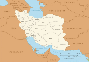
Different regions of Iran have suffered for a long time from spatial inequalities because of the shortage of infrastructure and educational services. Educational activities play an important role in social and economic mobility and development of regions. The closing of educational centers due to the spread of the Covid-19 epidemic affects the spatial and social inequalities of the regions in Iran. The current study aims to examine spatial inequality of educational indicators during two periods: “before” the outbreak of Covid-19 (2018) and “during” its outbreak (2021). Then the provinces of Iran are stratified in terms of educational indicators by using the combined method of TOPSIS and Shannon's entropy, cluster analysis in Spss and using ArcGis. The most important factors of educational inequality during the Covid19 period were found by using Pearson's correlation coefficient and multivariate regression. The results showed that in the pre-Covid period, the distance between the most privileged province (Bushehr) and the most deprived province (Tehran) was 4.5. This amount has increased to 5.5 during the period of Covid-19, which shows the increase of inequalities due to the conditions of Covid-19. Further investigation of the results shows that the inequality of educational indicators among the provinces of the country has a clear relationship with the changes in population movements in different regions of Iran. On the other hand, due to the digital education without need for educational space in the conditions of Covid-19, the importance of the existence of physical infrastructure has been reduced. And two key variables as population density and internet penetration rate play an important role in the provinces’ educational indicators during the period of covid-19. These results could help the spatial planning to reduce inequalities in different regions of the country.
Abstract Image

教育不平等的空间分析及其影响因素评估:伊朗 COVID-19 流行前和流行期间
由于缺乏基础设施和教育服务,伊朗不同地区长期以来一直遭受空间不平等之苦。教育活动在社会和经济流动以及地区发展中发挥着重要作用。由于 "Covid-19 "疫情的蔓延而关闭教育中心,影响了伊朗各地区的空间和社会不平等。本研究旨在考察两个时期教育指标的空间不平等情况:"Covid-19疫情爆发前(2018年)和爆发期间(2021年)。然后,使用 TOPSIS 和香农熵的组合方法、Spss 聚类分析以及 ArcGis 对伊朗各省的教育指标进行分层。通过使用皮尔逊相关系数和多元回归法,找到了 Covid19 期间教育不平等的最重要因素。结果表明,在 Covid 前,最富裕省份(布什尔)与最贫困省份(德黑兰)之间的距离为 4.5。在 Covid-19 期间,这一数值增加到了 5.5,这表明由于 Covid-19 的条件,不平等现象有所加剧。对结果的进一步调查表明,全国各省之间教育指标的不平等与伊朗不同地区人口流动的变化有着明显的关系。另一方面,由于在 Covid-19 条件下无需教育空间的数字化教育,有形基础设施存在的重要性已经降低。在 Covid-19 期间,人口密度和互联网普及率这两个关键变量对各省的教育指标起着重要作用。这些结果有助于空间规划,以减少国内不同地区的不平等现象。
本文章由计算机程序翻译,如有差异,请以英文原文为准。
求助全文
约1分钟内获得全文 求助全文
来源期刊
CiteScore
3.80
自引率
5.30%
发文量
57
期刊介绍: Description The journal has an applied focus: it actively promotes the importance of geographical research in real world settings It is policy-relevant: it seeks both a readership and contributions from practitioners as well as academics The substantive foundation is spatial analysis: the use of quantitative techniques to identify patterns and processes within geographic environments The combination of these points, which are fully reflected in the naming of the journal, establishes a unique position in the marketplace. RationaleA geographical perspective has always been crucial to the understanding of the social and physical organisation of the world around us. The techniques of spatial analysis provide a powerful means for the assembly and interpretation of evidence, and thus to address critical questions about issues such as crime and deprivation, immigration and demographic restructuring, retailing activity and employment change, resource management and environmental improvement. Many of these issues are equally important to academic research as they are to policy makers and Applied Spatial Analysis and Policy aims to close the gap between these two perspectives by providing a forum for discussion of applied research in a range of different contexts  Topical and interdisciplinaryIncreasingly government organisations, administrative agencies and private businesses are requiring research to support their ‘evidence-based’ strategies or policies. Geographical location is critical in much of this work which extends across a wide range of disciplines including demography, actuarial sciences, statistics, public sector planning, business planning, economics, epidemiology, sociology, social policy, health research, environmental management.   FocusApplied Spatial Analysis and Policy will draw on applied research from diverse problem domains, such as transport, policing, education, health, environment and leisure, in different international contexts. The journal will therefore provide insights into the variations in phenomena that exist across space, it will provide evidence for comparative policy analysis between domains and between locations, and stimulate ideas about the translation of spatial analysis methods and techniques across varied policy contexts. It is essential to know how to measure, monitor and understand spatial distributions, many of which have implications for those with responsibility to plan and enhance the society and the environment in which we all exist.   Readership and Editorial BoardAs a journal focused on applications of methods of spatial analysis, Applied Spatial Analysis and Policy will be of interest to scholars and students in a wide range of academic fields, to practitioners in government and administrative agencies and to consultants in private sector organisations. The Editorial Board reflects the international and multidisciplinary nature of the journal.
×
引用
GB/T 7714-2015
复制
MLA
复制
APA
复制
导出至
BibTeX EndNote RefMan NoteFirst NoteExpress
×
提示
您的信息不完整,为了账户安全,请先补充。
现在去补充
×
提示
您因"违规操作"
具体请查看互助需知
我知道了
×
提示
确定
请完成安全验证×
copy
已复制链接
快去分享给好友吧!
我知道了
右上角分享
点击右上角分享
0
联系我们:info@booksci.cn Book学术提供免费学术资源搜索服务,方便国内外学者检索中英文文献。致力于提供最便捷和优质的服务体验。 Copyright © 2023 布克学术 All rights reserved.
京ICP备2023020795号-1
ghs 京公网安备 11010802042870号
Book学术文献互助
Book学术文献互助群
群 号:481959085
Book学术官方微信