Peter S. Larson, Jamie Steis Thorsby, Xinyu Liu, Eleanor King, Carol J. Miller
{"title":"Crowd-based spatial risk assessment of urban flooding: Results from a municipal flood hotline in Detroit, MI","authors":"Peter S. Larson, Jamie Steis Thorsby, Xinyu Liu, Eleanor King, Carol J. Miller","doi":"10.1111/jfr3.12974","DOIUrl":null,"url":null,"abstract":"<p>Climate change is increasing the frequency and intensity of extreme precipitation events, raising the risk of urban flood disasters. This study uses a crowd-sourced municipal call database to characterize the spatial distribution of flood risk in Detroit, MI. Call data including dates and addresses were obtained from the City of Detroit Department of Public Works for 2021. Calls were mapped and aggregated to census tract counts and merged with neighborhood-level data. Associations of predictors with flood calls were tested using spatial regression models. Flooding calls were located throughout the city but were concentrated in specific areas. Multivariate models of census tract level call counts indicated that increased poverty and Black, immigrant, and older residents were positively associated with flood calls, while increased elevation was associated with protective effects. Longer distances from waste water interceptors were associated with higher risk for calls. Crowd-sourced flood hotline call data can be used for effective spatial flood risk assessment. Though flooding occurs throughout the city of Detroit, infrastructural, neighborhood, and household factors influence flooding extent. Limitations included the self-reported nature of calls. Future modeling efforts might include input from local stakeholders to improve spatial risk assessment.</p>","PeriodicalId":49294,"journal":{"name":"Journal of Flood Risk Management","volume":"17 2","pages":""},"PeriodicalIF":3.0000,"publicationDate":"2024-02-13","publicationTypes":"Journal Article","fieldsOfStudy":null,"isOpenAccess":false,"openAccessPdf":"https://onlinelibrary.wiley.com/doi/epdf/10.1111/jfr3.12974","citationCount":"0","resultStr":null,"platform":"Semanticscholar","paperid":null,"PeriodicalName":"Journal of Flood Risk Management","FirstCategoryId":"93","ListUrlMain":"https://onlinelibrary.wiley.com/doi/10.1111/jfr3.12974","RegionNum":3,"RegionCategory":"环境科学与生态学","ArticlePicture":[],"TitleCN":null,"AbstractTextCN":null,"PMCID":null,"EPubDate":"","PubModel":"","JCR":"Q2","JCRName":"ENVIRONMENTAL SCIENCES","Score":null,"Total":0}
引用次数: 0
Abstract
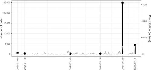
Climate change is increasing the frequency and intensity of extreme precipitation events, raising the risk of urban flood disasters. This study uses a crowd-sourced municipal call database to characterize the spatial distribution of flood risk in Detroit, MI. Call data including dates and addresses were obtained from the City of Detroit Department of Public Works for 2021. Calls were mapped and aggregated to census tract counts and merged with neighborhood-level data. Associations of predictors with flood calls were tested using spatial regression models. Flooding calls were located throughout the city but were concentrated in specific areas. Multivariate models of census tract level call counts indicated that increased poverty and Black, immigrant, and older residents were positively associated with flood calls, while increased elevation was associated with protective effects. Longer distances from waste water interceptors were associated with higher risk for calls. Crowd-sourced flood hotline call data can be used for effective spatial flood risk assessment. Though flooding occurs throughout the city of Detroit, infrastructural, neighborhood, and household factors influence flooding extent. Limitations included the self-reported nature of calls. Future modeling efforts might include input from local stakeholders to improve spatial risk assessment.
期刊介绍:
Journal of Flood Risk Management provides an international platform for knowledge sharing in all areas related to flood risk. Its explicit aim is to disseminate ideas across the range of disciplines where flood related research is carried out and it provides content ranging from leading edge academic papers to applied content with the practitioner in mind.
Readers and authors come from a wide background and include hydrologists, meteorologists, geographers, geomorphologists, conservationists, civil engineers, social scientists, policy makers, insurers and practitioners. They share an interest in managing the complex interactions between the many skills and disciplines that underpin the management of flood risk across the world.

 求助内容:
求助内容: 应助结果提醒方式:


