Identifying critical source areas of non-point source pollution to enhance water quality: Integrated SWAT modeling and multi-variable statistical analysis to reveal key variables and thresholds
Shubo Fang , Matthew J. Deitch , Tesfay G. Gebremicael , Christine Angelini , Collin J Ortals
{"title":"Identifying critical source areas of non-point source pollution to enhance water quality: Integrated SWAT modeling and multi-variable statistical analysis to reveal key variables and thresholds","authors":"Shubo Fang , Matthew J. Deitch , Tesfay G. Gebremicael , Christine Angelini , Collin J Ortals","doi":"10.1016/j.watres.2024.121286","DOIUrl":null,"url":null,"abstract":"<div><p>By integrating soil and water assessment tool (SWAT) modeling and land use and land cover (LULC) based multi-variable statistical analysis, this study aimed to identify driving factors, potential thresholds, and critical source areas (CSAs) to enhance water quality in southern Alabama and northwest Florida's Choctawhatchee Watershed. The results revealed the significance of forest cover and of the lumped developed areas and cultivated crops (“Source Areas”) in influencing water quality. The stepwise linear regression analysis based on self-organizing maps (SOMs) showed that a negative correlation between forest percent cover and total nitrogen (TN), organic nitrogen (ORGN), and organic phosphorus (ORGP), highlighting the importance of forests in reducing nutrient loads. Conversely, Source Area percentage was positively correlated with total phosphorus (TP) loads, indicating the influence of human activities on TP levels. The receiver operating characteristic (ROC) curve analysis determined thresholds for forest percentage and Source Area percentage as 37.47 % and 20.26 %, respectively. These thresholds serve as important reference points for identifying CSAs. The CSAs identified based on these thresholds covered a relatively small portion (28 %) but contributed 47 % of TN and 50 % of TP of the whole watershed. The study underscores the importance of considering both physical process-based modeling and multi-variable statistical analysis for a comprehensive understanding of watershed management, i.e., the identification of CSAs and the associated variables and their tipping points to maintain water quality.</p></div>","PeriodicalId":443,"journal":{"name":"Water Research","volume":"253 ","pages":"Article 121286"},"PeriodicalIF":12.4000,"publicationDate":"2024-02-06","publicationTypes":"Journal Article","fieldsOfStudy":null,"isOpenAccess":false,"openAccessPdf":"","citationCount":"0","resultStr":null,"platform":"Semanticscholar","paperid":null,"PeriodicalName":"Water Research","FirstCategoryId":"93","ListUrlMain":"https://www.sciencedirect.com/science/article/pii/S004313542400188X","RegionNum":1,"RegionCategory":"环境科学与生态学","ArticlePicture":[],"TitleCN":null,"AbstractTextCN":null,"PMCID":null,"EPubDate":"","PubModel":"","JCR":"Q1","JCRName":"ENGINEERING, ENVIRONMENTAL","Score":null,"Total":0}
引用次数: 0
Abstract
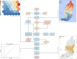
By integrating soil and water assessment tool (SWAT) modeling and land use and land cover (LULC) based multi-variable statistical analysis, this study aimed to identify driving factors, potential thresholds, and critical source areas (CSAs) to enhance water quality in southern Alabama and northwest Florida's Choctawhatchee Watershed. The results revealed the significance of forest cover and of the lumped developed areas and cultivated crops (“Source Areas”) in influencing water quality. The stepwise linear regression analysis based on self-organizing maps (SOMs) showed that a negative correlation between forest percent cover and total nitrogen (TN), organic nitrogen (ORGN), and organic phosphorus (ORGP), highlighting the importance of forests in reducing nutrient loads. Conversely, Source Area percentage was positively correlated with total phosphorus (TP) loads, indicating the influence of human activities on TP levels. The receiver operating characteristic (ROC) curve analysis determined thresholds for forest percentage and Source Area percentage as 37.47 % and 20.26 %, respectively. These thresholds serve as important reference points for identifying CSAs. The CSAs identified based on these thresholds covered a relatively small portion (28 %) but contributed 47 % of TN and 50 % of TP of the whole watershed. The study underscores the importance of considering both physical process-based modeling and multi-variable statistical analysis for a comprehensive understanding of watershed management, i.e., the identification of CSAs and the associated variables and their tipping points to maintain water quality.
期刊介绍:
Water Research, along with its open access companion journal Water Research X, serves as a platform for publishing original research papers covering various aspects of the science and technology related to the anthropogenic water cycle, water quality, and its management worldwide. The audience targeted by the journal comprises biologists, chemical engineers, chemists, civil engineers, environmental engineers, limnologists, and microbiologists. The scope of the journal include:
•Treatment processes for water and wastewaters (municipal, agricultural, industrial, and on-site treatment), including resource recovery and residuals management;
•Urban hydrology including sewer systems, stormwater management, and green infrastructure;
•Drinking water treatment and distribution;
•Potable and non-potable water reuse;
•Sanitation, public health, and risk assessment;
•Anaerobic digestion, solid and hazardous waste management, including source characterization and the effects and control of leachates and gaseous emissions;
•Contaminants (chemical, microbial, anthropogenic particles such as nanoparticles or microplastics) and related water quality sensing, monitoring, fate, and assessment;
•Anthropogenic impacts on inland, tidal, coastal and urban waters, focusing on surface and ground waters, and point and non-point sources of pollution;
•Environmental restoration, linked to surface water, groundwater and groundwater remediation;
•Analysis of the interfaces between sediments and water, and between water and atmosphere, focusing specifically on anthropogenic impacts;
•Mathematical modelling, systems analysis, machine learning, and beneficial use of big data related to the anthropogenic water cycle;
•Socio-economic, policy, and regulations studies.
 求助内容:
求助内容: 应助结果提醒方式:


