João Lino Pereira, Emmanouil A. Varouchakis, George P. Karatzas, Leonardo Azevedo
{"title":"Uncertainty Quantification in Geostatistical Modelling of Saltwater Intrusion at a Coastal Aquifer System","authors":"João Lino Pereira, Emmanouil A. Varouchakis, George P. Karatzas, Leonardo Azevedo","doi":"10.1007/s11004-023-10120-7","DOIUrl":null,"url":null,"abstract":"<p>Groundwater resources in Mediterranean coastal aquifers are under several threats including saltwater intrusion. This situation is exacerbated by the absence of sustainable management plans for groundwater resources. Management and monitoring of groundwater systems require an integrated approach and the joint interpretation of any available information. This work investigates how uncertainty can be integrated within the geo-modelling workflow when creating numerical three-dimensional aquifer models with electrical resistivity borehole logs, geostatistical simulation and Bayesian model averaging. Multiple geological scenarios of electrical resistivity are created with geostatistical simulation by removing one borehole at a time from the set of available boreholes. To account for the spatial uncertainty simultaneously reflected by the multiple geostatistical scenarios, Bayesian model averaging is used to combine the probability distribution functions of each scenario into a global one, thus providing more credible uncertainty intervals. The proposed methodology is applied to a water-stressed groundwater system located in Crete that is threatened by saltwater intrusion. The results obtained agree with the general knowledge of this complex environment and enable sustainable groundwater management policies to be devised considering optimistic and pessimistic scenarios.</p>","PeriodicalId":51117,"journal":{"name":"Mathematical Geosciences","volume":"106 1","pages":""},"PeriodicalIF":3.6000,"publicationDate":"2024-01-02","publicationTypes":"Journal Article","fieldsOfStudy":null,"isOpenAccess":false,"openAccessPdf":"","citationCount":"0","resultStr":null,"platform":"Semanticscholar","paperid":null,"PeriodicalName":"Mathematical Geosciences","FirstCategoryId":"89","ListUrlMain":"https://doi.org/10.1007/s11004-023-10120-7","RegionNum":3,"RegionCategory":"地球科学","ArticlePicture":[],"TitleCN":null,"AbstractTextCN":null,"PMCID":null,"EPubDate":"","PubModel":"","JCR":"Q2","JCRName":"GEOSCIENCES, MULTIDISCIPLINARY","Score":null,"Total":0}
引用次数: 0
Abstract
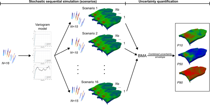
Groundwater resources in Mediterranean coastal aquifers are under several threats including saltwater intrusion. This situation is exacerbated by the absence of sustainable management plans for groundwater resources. Management and monitoring of groundwater systems require an integrated approach and the joint interpretation of any available information. This work investigates how uncertainty can be integrated within the geo-modelling workflow when creating numerical three-dimensional aquifer models with electrical resistivity borehole logs, geostatistical simulation and Bayesian model averaging. Multiple geological scenarios of electrical resistivity are created with geostatistical simulation by removing one borehole at a time from the set of available boreholes. To account for the spatial uncertainty simultaneously reflected by the multiple geostatistical scenarios, Bayesian model averaging is used to combine the probability distribution functions of each scenario into a global one, thus providing more credible uncertainty intervals. The proposed methodology is applied to a water-stressed groundwater system located in Crete that is threatened by saltwater intrusion. The results obtained agree with the general knowledge of this complex environment and enable sustainable groundwater management policies to be devised considering optimistic and pessimistic scenarios.
期刊介绍:
Mathematical Geosciences (formerly Mathematical Geology) publishes original, high-quality, interdisciplinary papers in geomathematics focusing on quantitative methods and studies of the Earth, its natural resources and the environment. This international publication is the official journal of the IAMG. Mathematical Geosciences is an essential reference for researchers and practitioners of geomathematics who develop and apply quantitative models to earth science and geo-engineering problems.
 求助内容:
求助内容: 应助结果提醒方式:


