Emilia Pafumi, Francesco Petruzzellis, Miris Castello, Alfredo Altobelli, Simona Maccherini, Duccio Rocchini, Giovanni Bacaro
{"title":"Using spectral diversity and heterogeneity measures to map habitat mosaics: An example from the Classical Karst","authors":"Emilia Pafumi, Francesco Petruzzellis, Miris Castello, Alfredo Altobelli, Simona Maccherini, Duccio Rocchini, Giovanni Bacaro","doi":"10.1111/avsc.12762","DOIUrl":null,"url":null,"abstract":"<div>\n \n \n <section>\n \n <h3> Questions</h3>\n \n <p>Can we map complex habitat mosaics from remote-sensing data? In doing this, are measures of spectral heterogeneity useful to improve image classification performance? Which measures are the most important? How can multitemporal data be integrated in a robust framework?</p>\n </section>\n \n <section>\n \n <h3> Location</h3>\n \n <p>Classical Karst (NE Italy).</p>\n </section>\n \n <section>\n \n <h3> Methods</h3>\n \n <p>First, a habitat map was produced from field surveys. Then, a collection of 12 monthly Sentinel-2 images was retrieved. Vegetation and spectral heterogeneity (SH) indices were computed and aggregated in four combinations: (1) monthly layers of vegetation and SH indices; (2) seasonal layers of vegetation and SH indices; (3) yearly layers of SH indices computed across the months; and (4) yearly layers of SH indices computed across the seasons. For each combination, a Random Forest classification was performed, first with the complete set of input layers and then with a subset obtained by recursive feature elimination. Training and validation points were independently extracted from field data.</p>\n </section>\n \n <section>\n \n <h3> Results</h3>\n \n <p>The maximum overall accuracy (0.72) was achieved by using seasonally aggregated vegetation and SH indices, after the number of vegetation types was reduced by aggregation from 26 to 11. The use of SH measures significantly increased the overall accuracy of the classification. The spectral β-diversity was the most important variable in most cases, while the spectral α-diversity and Rao's <i>Q</i> had a low relative importance, possibly because some habitat patches were small compared to the window used to compute the indices.</p>\n </section>\n \n <section>\n \n <h3> Conclusions</h3>\n \n <p>The results are promising and suggest that image classification frameworks could benefit from the inclusion of SH measures, rarely included before. Habitat mapping in complex landscapes can thus be improved in a cost- and time-effective way, suitable for monitoring applications.</p>\n </section>\n </div>","PeriodicalId":55494,"journal":{"name":"Applied Vegetation Science","volume":"26 4","pages":""},"PeriodicalIF":2.6000,"publicationDate":"2023-12-27","publicationTypes":"Journal Article","fieldsOfStudy":null,"isOpenAccess":false,"openAccessPdf":"https://onlinelibrary.wiley.com/doi/epdf/10.1111/avsc.12762","citationCount":"0","resultStr":null,"platform":"Semanticscholar","paperid":null,"PeriodicalName":"Applied Vegetation Science","FirstCategoryId":"93","ListUrlMain":"https://onlinelibrary.wiley.com/doi/10.1111/avsc.12762","RegionNum":3,"RegionCategory":"环境科学与生态学","ArticlePicture":[],"TitleCN":null,"AbstractTextCN":null,"PMCID":null,"EPubDate":"","PubModel":"","JCR":"Q3","JCRName":"ECOLOGY","Score":null,"Total":0}
引用次数: 0
Abstract
Questions
Can we map complex habitat mosaics from remote-sensing data? In doing this, are measures of spectral heterogeneity useful to improve image classification performance? Which measures are the most important? How can multitemporal data be integrated in a robust framework?
Location
Classical Karst (NE Italy).
Methods
First, a habitat map was produced from field surveys. Then, a collection of 12 monthly Sentinel-2 images was retrieved. Vegetation and spectral heterogeneity (SH) indices were computed and aggregated in four combinations: (1) monthly layers of vegetation and SH indices; (2) seasonal layers of vegetation and SH indices; (3) yearly layers of SH indices computed across the months; and (4) yearly layers of SH indices computed across the seasons. For each combination, a Random Forest classification was performed, first with the complete set of input layers and then with a subset obtained by recursive feature elimination. Training and validation points were independently extracted from field data.
Results
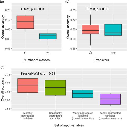
The maximum overall accuracy (0.72) was achieved by using seasonally aggregated vegetation and SH indices, after the number of vegetation types was reduced by aggregation from 26 to 11. The use of SH measures significantly increased the overall accuracy of the classification. The spectral β-diversity was the most important variable in most cases, while the spectral α-diversity and Rao's Q had a low relative importance, possibly because some habitat patches were small compared to the window used to compute the indices.
Conclusions
The results are promising and suggest that image classification frameworks could benefit from the inclusion of SH measures, rarely included before. Habitat mapping in complex landscapes can thus be improved in a cost- and time-effective way, suitable for monitoring applications.
期刊介绍:
Applied Vegetation Science focuses on community-level topics relevant to human interaction with vegetation, including global change, nature conservation, nature management, restoration of plant communities and of natural habitats, and the planning of semi-natural and urban landscapes. Vegetation survey, modelling and remote-sensing applications are welcome. Papers on vegetation science which do not fit to this scope (do not have an applied aspect and are not vegetation survey) should be directed to our associate journal, the Journal of Vegetation Science. Both journals publish papers on the ecology of a single species only if it plays a key role in structuring plant communities.
 求助内容:
求助内容: 应助结果提醒方式:


