Significant opportunities for tree crop expansion on marginal lands in the Midwest, USA
Abstract
Introduction
Tree crop orchards can help diversify the monocropping practices in agricultural lands such as the Midwestern region of the United States which is currently dominated by corn-soybean rotation. These crops can not only expand farm income but also help stabilize soil, purify water, and provide other ecosystem services. Despite these benefits, tree crops as agroforestry systems are not widely established in the region. Identifying marginal land that is more suitable for tree crops over row crops can help the growers and the environment.
Materials and Methods
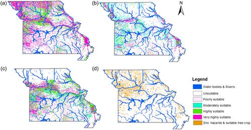
Using the case of Missouri, USA, this study mapped marginal land for nut-producing tree crops using a three-step process. The first step includes the identification of marginal land suitable for a wide variety of tree crops. The second step involved GIS-based multicriteria analysis of biophysically suitable areas for three commercially viable tree species, that is, eastern black walnut, pecan, and Chinese chestnut. The final step maps the marginal land for tree crops based on their suitability to grow under different environmental vulnerabilities, mainly flooding, erosion, and sloped conditions. The Gridded Soil Survey Geographic Database developed by the United States Department of Agriculture provided information on soil biophysical and environmental characteristics.
Results
The spatial analysis showed that Missouri has around 16,000 sq. km of land suitable for Black walnut, followed by 10,801 sq. km and 4587 sq. km for pecan and Chinese chestnut, respectively. The study found very few tree crop orchards on these marginal lands.
Conclusion
There are ample opportunities to expand tree crops on marginal cropland. Converting these lands to tree crops could provide communities with economic, human health, and environmental benefits. This multistep methodology could serve as a screening tool to identify tree-cropping areas for environmental improvement and rural America's economic revitalization.


 求助内容:
求助内容: 应助结果提醒方式:


