Holocene sedimentary history of the Silala River (Antofagasta Region, Chile)

IF 6.8 1区 地球科学 Q1 ENVIRONMENTAL SCIENCES
Claudio Latorre, Matías Frugone‐Álvarez
{"title":"Holocene sedimentary history of the Silala River (Antofagasta Region, Chile)","authors":"Claudio Latorre, Matías Frugone‐Álvarez","doi":"10.1002/wat2.1699","DOIUrl":null,"url":null,"abstract":"Abstract Assessing past and ongoing climate change in the central Andes is critical for understanding the impact of future environmental changes under anthropogenic warming. Emerging from springs located in Bolivia and flowing into northern Chile's Atacama Desert, the Silala River contains inset, terraced wetland (or in‐stream) deposits that provide a unique opportunity to study the impact of past hydroclimate change in a sensitive groundwater system with a small catchment area. After an initial (late Pleistocene) period of deep incision to form the present ravine, in‐stream wetland fine‐grained deposits formed during three phases of aggradation dated to >8.5–1.9 ka (Unit 1), >0.65–0.2 ka (Unit 2), and <0.2 ka to the recent 20th century (Unit 4). These phases of accumulation were coeval with periods of well‐dated records of elevated groundwater tables throughout northern Chile. Phases of abrupt downcutting occurred due to a lowering of the water table after 1.9 ka and before 0.2 ka. The cycle of erosion and deposition clearly continues to the present as evinced by the very recent (21st century) incision of Unit 4 (>1.5 m in some areas) throughout sectors of the Silala where dried‐out standing vegetation can be seen. Such recent incision may be due to multiple different factors, including recent climate change coupled with intense extraction of groundwater resources by the copper mining industry. This article is categorized under: Human Water > Water Governance Science of Water > Hydrological Processes Science of Water > Water and Environmental Change","PeriodicalId":23774,"journal":{"name":"Wiley Interdisciplinary Reviews: Water","volume":" 1","pages":"0"},"PeriodicalIF":6.8000,"publicationDate":"2023-11-09","publicationTypes":"Journal Article","fieldsOfStudy":null,"isOpenAccess":false,"openAccessPdf":"","citationCount":"0","resultStr":null,"platform":"Semanticscholar","paperid":null,"PeriodicalName":"Wiley Interdisciplinary Reviews: Water","FirstCategoryId":"1085","ListUrlMain":"https://doi.org/10.1002/wat2.1699","RegionNum":1,"RegionCategory":"地球科学","ArticlePicture":[],"TitleCN":null,"AbstractTextCN":null,"PMCID":null,"EPubDate":"","PubModel":"","JCR":"Q1","JCRName":"ENVIRONMENTAL SCIENCES","Score":null,"Total":0}
引用次数: 0

Abstract

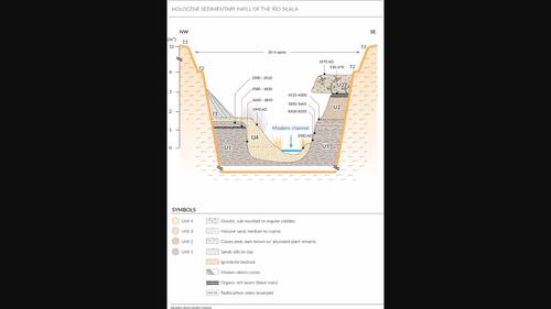
Abstract Assessing past and ongoing climate change in the central Andes is critical for understanding the impact of future environmental changes under anthropogenic warming. Emerging from springs located in Bolivia and flowing into northern Chile's Atacama Desert, the Silala River contains inset, terraced wetland (or in‐stream) deposits that provide a unique opportunity to study the impact of past hydroclimate change in a sensitive groundwater system with a small catchment area. After an initial (late Pleistocene) period of deep incision to form the present ravine, in‐stream wetland fine‐grained deposits formed during three phases of aggradation dated to >8.5–1.9 ka (Unit 1), >0.65–0.2 ka (Unit 2), and <0.2 ka to the recent 20th century (Unit 4). These phases of accumulation were coeval with periods of well‐dated records of elevated groundwater tables throughout northern Chile. Phases of abrupt downcutting occurred due to a lowering of the water table after 1.9 ka and before 0.2 ka. The cycle of erosion and deposition clearly continues to the present as evinced by the very recent (21st century) incision of Unit 4 (>1.5 m in some areas) throughout sectors of the Silala where dried‐out standing vegetation can be seen. Such recent incision may be due to multiple different factors, including recent climate change coupled with intense extraction of groundwater resources by the copper mining industry. This article is categorized under: Human Water > Water Governance Science of Water > Hydrological Processes Science of Water > Water and Environmental Change
Abstract Image

西拉拉河(智利Antofagasta地区)全新世沉积史
评估安第斯山脉中部过去和正在发生的气候变化对于理解人为变暖下未来环境变化的影响至关重要。西拉拉河(Silala River)发源于玻利维亚的泉水,流入智利北部的阿塔卡马沙漠(Atacama Desert),它包含嵌入的梯田湿地(或流中)沉积物,为研究过去水文气候变化对具有小集水区的敏感地下水系统的影响提供了独特的机会。经过最初(晚更新世)的深切口形成现在的峡谷后,河中湿地细粒沉积物在三个沉积阶段形成,时间分别为8.5-1.9 ka(第1单元)、0.65-0.2 ka(第2单元)和0.2 ka至20世纪晚期(第4单元)。这些沉积阶段与整个智利北部地下水水位升高的年代一致。在1.9 ka之后和0.2 ka之前,由于地下水位的下降,出现了突发性下降的阶段。侵蚀和沉积的循环显然持续到现在,最近(21世纪)4号单元的切口(某些地区1.5米)在整个Silala地区可以看到干燥的直立植被。这种最近的切口可能是由于多种不同的因素造成的,包括最近的气候变化以及铜矿采矿业对地下水资源的大量开采。本文分类如下:人类用水;水治理科学;水文过程科学(英文);水与环境变化
本文章由计算机程序翻译,如有差异,请以英文原文为准。
求助全文
约1分钟内获得全文 求助全文
来源期刊
Wiley Interdisciplinary Reviews: Water
Wiley Interdisciplinary Reviews: Water Environmental Science-Ecology
CiteScore
16.60
自引率
3.70%
发文量
56
期刊介绍: The WIREs series is truly unique, blending the best aspects of encyclopedic reference works and review journals into a dynamic online format. These remarkable resources foster a research culture that transcends disciplinary boundaries, all while upholding the utmost scientific and presentation excellence. However, they go beyond traditional publications and are, in essence, ever-evolving databases of the latest cutting-edge reviews.
×
引用
GB/T 7714-2015
复制
MLA
复制
APA
复制
导出至
BibTeX EndNote RefMan NoteFirst NoteExpress
×
提示
您的信息不完整,为了账户安全,请先补充。
现在去补充
×
提示
您因"违规操作"
具体请查看互助需知
我知道了
×
提示
确定
请完成安全验证×
copy
已复制链接
快去分享给好友吧!
我知道了
右上角分享
点击右上角分享
0
联系我们:info@booksci.cn Book学术提供免费学术资源搜索服务,方便国内外学者检索中英文文献。致力于提供最便捷和优质的服务体验。 Copyright © 2023 布克学术 All rights reserved.
京ICP备2023020795号-1
ghs 京公网安备 11010802042870号
Book学术文献互助
Book学术文献互助群
群 号:481959085
Book学术官方微信