{"title":"在跨学科研究中学习地理信息系统的建议框架和指导方针","authors":"Patrick Rickles, Claire Ellul, Muki Haklay","doi":"10.1002/geo2.46","DOIUrl":null,"url":null,"abstract":"Interdisciplinary research with geographic information systems (GIS) can be rewarding as researchers from different disciplines have the opportunity to create something novel. GIS, though, is known to be difficult to use and learn. It is imperative for its successful use in projects that those who need to use GIS are able to learn it quickly and easily. To better support interdisciplinary research with GIS, it is necessary to understand what researchers with interdisciplinary experience wanted to use it for and how they learned it. The aim would be to advise geography educators on creating learning resources that could compliment or supplement existing learning approaches used by interdisciplinary researchers to improve the learning experience and uptake of GIS. This article explores the results from an online survey and interviews conducted between July 2014 and August 2015 with participants from the UK, the US and Europe on how interdisciplinary researchers learned GIS and which resources and platforms were utilised. Guidelines and a framework are presented, modifying the Technological Pedagogical and Content Knowledge framework, incorporating informal and context-based learning and GIS concepts from the Geographic Information Science and Technology Body of Knowledge. Findings show that interdisciplinary researchers want to use GIS to capture, analyse and visualise information; they largely use informal learning approaches (e.g. internet searches, watching a video, ask a more experienced person); and they predominantly use ArcGIS, QGIS and web GIS platforms. Future work suggests resources use contextually relevant learning activities and bear in mind nuances of disciplinary language.","PeriodicalId":44089,"journal":{"name":"Geo-Geography and Environment","volume":null,"pages":null},"PeriodicalIF":1.7000,"publicationDate":"2017-12-11","publicationTypes":"Journal Article","fieldsOfStudy":null,"isOpenAccess":false,"openAccessPdf":"https://sci-hub-pdf.com/10.1002/geo2.46","citationCount":"23","resultStr":"{\"title\":\"A suggested framework and guidelines for learning GIS in interdisciplinary research\",\"authors\":\"Patrick Rickles, Claire Ellul, Muki Haklay\",\"doi\":\"10.1002/geo2.46\",\"DOIUrl\":null,\"url\":null,\"abstract\":\"Interdisciplinary research with geographic information systems (GIS) can be rewarding as researchers from different disciplines have the opportunity to create something novel. GIS, though, is known to be difficult to use and learn. It is imperative for its successful use in projects that those who need to use GIS are able to learn it quickly and easily. To better support interdisciplinary research with GIS, it is necessary to understand what researchers with interdisciplinary experience wanted to use it for and how they learned it. The aim would be to advise geography educators on creating learning resources that could compliment or supplement existing learning approaches used by interdisciplinary researchers to improve the learning experience and uptake of GIS. This article explores the results from an online survey and interviews conducted between July 2014 and August 2015 with participants from the UK, the US and Europe on how interdisciplinary researchers learned GIS and which resources and platforms were utilised. Guidelines and a framework are presented, modifying the Technological Pedagogical and Content Knowledge framework, incorporating informal and context-based learning and GIS concepts from the Geographic Information Science and Technology Body of Knowledge. Findings show that interdisciplinary researchers want to use GIS to capture, analyse and visualise information; they largely use informal learning approaches (e.g. internet searches, watching a video, ask a more experienced person); and they predominantly use ArcGIS, QGIS and web GIS platforms. Future work suggests resources use contextually relevant learning activities and bear in mind nuances of disciplinary language.\",\"PeriodicalId\":44089,\"journal\":{\"name\":\"Geo-Geography and Environment\",\"volume\":null,\"pages\":null},\"PeriodicalIF\":1.7000,\"publicationDate\":\"2017-12-11\",\"publicationTypes\":\"Journal Article\",\"fieldsOfStudy\":null,\"isOpenAccess\":false,\"openAccessPdf\":\"https://sci-hub-pdf.com/10.1002/geo2.46\",\"citationCount\":\"23\",\"resultStr\":null,\"platform\":\"Semanticscholar\",\"paperid\":null,\"PeriodicalName\":\"Geo-Geography and Environment\",\"FirstCategoryId\":\"1085\",\"ListUrlMain\":\"https://onlinelibrary.wiley.com/doi/10.1002/geo2.46\",\"RegionNum\":0,\"RegionCategory\":null,\"ArticlePicture\":[],\"TitleCN\":null,\"AbstractTextCN\":null,\"PMCID\":null,\"EPubDate\":\"\",\"PubModel\":\"\",\"JCR\":\"Q2\",\"JCRName\":\"GEOGRAPHY\",\"Score\":null,\"Total\":0}","platform":"Semanticscholar","paperid":null,"PeriodicalName":"Geo-Geography and Environment","FirstCategoryId":"1085","ListUrlMain":"https://onlinelibrary.wiley.com/doi/10.1002/geo2.46","RegionNum":0,"RegionCategory":null,"ArticlePicture":[],"TitleCN":null,"AbstractTextCN":null,"PMCID":null,"EPubDate":"","PubModel":"","JCR":"Q2","JCRName":"GEOGRAPHY","Score":null,"Total":0}
A suggested framework and guidelines for learning GIS in interdisciplinary research
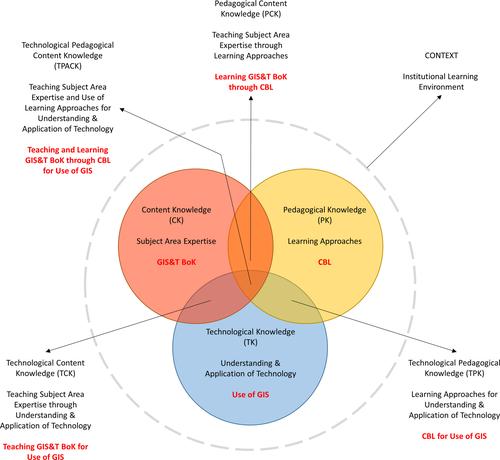
Interdisciplinary research with geographic information systems (GIS) can be rewarding as researchers from different disciplines have the opportunity to create something novel. GIS, though, is known to be difficult to use and learn. It is imperative for its successful use in projects that those who need to use GIS are able to learn it quickly and easily. To better support interdisciplinary research with GIS, it is necessary to understand what researchers with interdisciplinary experience wanted to use it for and how they learned it. The aim would be to advise geography educators on creating learning resources that could compliment or supplement existing learning approaches used by interdisciplinary researchers to improve the learning experience and uptake of GIS. This article explores the results from an online survey and interviews conducted between July 2014 and August 2015 with participants from the UK, the US and Europe on how interdisciplinary researchers learned GIS and which resources and platforms were utilised. Guidelines and a framework are presented, modifying the Technological Pedagogical and Content Knowledge framework, incorporating informal and context-based learning and GIS concepts from the Geographic Information Science and Technology Body of Knowledge. Findings show that interdisciplinary researchers want to use GIS to capture, analyse and visualise information; they largely use informal learning approaches (e.g. internet searches, watching a video, ask a more experienced person); and they predominantly use ArcGIS, QGIS and web GIS platforms. Future work suggests resources use contextually relevant learning activities and bear in mind nuances of disciplinary language.
期刊介绍:
Geo is a fully open access international journal publishing original articles from across the spectrum of geographical and environmental research. Geo welcomes submissions which make a significant contribution to one or more of the journal’s aims. These are to: • encompass the breadth of geographical, environmental and related research, based on original scholarship in the sciences, social sciences and humanities; • bring new understanding to and enhance communication between geographical research agendas, including human-environment interactions, global North-South relations and academic-policy exchange; • advance spatial research and address the importance of geographical enquiry to the understanding of, and action about, contemporary issues; • foster methodological development, including collaborative forms of knowledge production, interdisciplinary approaches and the innovative use of quantitative and/or qualitative data sets; • publish research articles, review papers, data and digital humanities papers, and commentaries which are of international significance.