{"title":"根据东伯拉哥尼亚和瓦尔达尔区的地表地质学、生物地层学以及中希腊半岛下方地幔的地震-地貌图像,研究了瓦尔达尔洋(北新特提斯西部)从早中侏罗世到古新世时期的封闭情况。","authors":"Rudolph Scherreiks, Marcelle BouDagher-Fadel","doi":"10.14324/111.444/ucloe.000024","DOIUrl":null,"url":null,"abstract":"<p><p>Seismic tomographic images of the mantle below the Hellenides indicate that the Vardar Ocean probably had a composite width of over 3000 km. From surface geology we know that this ocean was initially located between two passive margins: Pelagonian Adria in the west and Serbo-Macedonian-Eurasia in the east. Pelagonia was covered by a carbonate platform that accumulated, during Late Triassic to Early Cretaceous time, where highly diversified carbonate sedimentary environments evolved and reacted to the adjacent, converging Vardar Ocean plate. We conceive that on the east side of the Vardar Ocean, a Cretaceous carbonate platform evolved from the Aptian to the Maastrichtian time in the forearc basin of the Vardar supra-subduction volcanic arc complex. The closure of the Vardar Ocean occurred in one episode of ophiolite obduction and in two episodes of intra-oceanic subduction. <b>1.</b> During the Middle Jurassic time a 1200-km slab of west Vardar lithosphere subducted beneath the supra-subduction, 'Eohellenic', arc, while a 200-km-wide slab obducted onto Pelagonia between the Callovian and Valanginian times. <b>2.</b> During the Late Jurassic through to the Cretaceous time a 1700-km-wide slab subducted beneath the evolving east Vardar-zone arc-complex. Pelagonia, the trailing edge of the subducting east-Vardar Ocean slab, crashed and underthrust the Vardar arc complex during the Paleocene time and ultimately crashed with Serbo-Macedonia. Since the late Early Jurassic time, the Hellenides have moved about 3000 km toward the northeast while the Atlantic Ocean spread.</p>","PeriodicalId":75271,"journal":{"name":"UCL open environment","volume":"3 ","pages":"e024"},"PeriodicalIF":0.0000,"publicationDate":"2021-09-22","publicationTypes":"Journal Article","fieldsOfStudy":null,"isOpenAccess":false,"openAccessPdf":"https://www.ncbi.nlm.nih.gov/pmc/articles/PMC10208346/pdf/","citationCount":"0","resultStr":"{\"title\":\"The closure of the Vardar Ocean (the western domain of the northern Neotethys) from the early Middle Jurassic to the Paleocene time, based on the surface geology of eastern Pelagonia and the Vardar zone, biostratigraphy, and seismic-tomographic images of the mantle below the Central Hellenides.\",\"authors\":\"Rudolph Scherreiks, Marcelle BouDagher-Fadel\",\"doi\":\"10.14324/111.444/ucloe.000024\",\"DOIUrl\":null,\"url\":null,\"abstract\":\"<p><p>Seismic tomographic images of the mantle below the Hellenides indicate that the Vardar Ocean probably had a composite width of over 3000 km. From surface geology we know that this ocean was initially located between two passive margins: Pelagonian Adria in the west and Serbo-Macedonian-Eurasia in the east. Pelagonia was covered by a carbonate platform that accumulated, during Late Triassic to Early Cretaceous time, where highly diversified carbonate sedimentary environments evolved and reacted to the adjacent, converging Vardar Ocean plate. We conceive that on the east side of the Vardar Ocean, a Cretaceous carbonate platform evolved from the Aptian to the Maastrichtian time in the forearc basin of the Vardar supra-subduction volcanic arc complex. The closure of the Vardar Ocean occurred in one episode of ophiolite obduction and in two episodes of intra-oceanic subduction. <b>1.</b> During the Middle Jurassic time a 1200-km slab of west Vardar lithosphere subducted beneath the supra-subduction, 'Eohellenic', arc, while a 200-km-wide slab obducted onto Pelagonia between the Callovian and Valanginian times. <b>2.</b> During the Late Jurassic through to the Cretaceous time a 1700-km-wide slab subducted beneath the evolving east Vardar-zone arc-complex. Pelagonia, the trailing edge of the subducting east-Vardar Ocean slab, crashed and underthrust the Vardar arc complex during the Paleocene time and ultimately crashed with Serbo-Macedonia. Since the late Early Jurassic time, the Hellenides have moved about 3000 km toward the northeast while the Atlantic Ocean spread.</p>\",\"PeriodicalId\":75271,\"journal\":{\"name\":\"UCL open environment\",\"volume\":\"3 \",\"pages\":\"e024\"},\"PeriodicalIF\":0.0000,\"publicationDate\":\"2021-09-22\",\"publicationTypes\":\"Journal Article\",\"fieldsOfStudy\":null,\"isOpenAccess\":false,\"openAccessPdf\":\"https://www.ncbi.nlm.nih.gov/pmc/articles/PMC10208346/pdf/\",\"citationCount\":\"0\",\"resultStr\":null,\"platform\":\"Semanticscholar\",\"paperid\":null,\"PeriodicalName\":\"UCL open environment\",\"FirstCategoryId\":\"1085\",\"ListUrlMain\":\"https://doi.org/10.14324/111.444/ucloe.000024\",\"RegionNum\":0,\"RegionCategory\":null,\"ArticlePicture\":[],\"TitleCN\":null,\"AbstractTextCN\":null,\"PMCID\":null,\"EPubDate\":\"2021/1/1 0:00:00\",\"PubModel\":\"eCollection\",\"JCR\":\"\",\"JCRName\":\"\",\"Score\":null,\"Total\":0}","platform":"Semanticscholar","paperid":null,"PeriodicalName":"UCL open environment","FirstCategoryId":"1085","ListUrlMain":"https://doi.org/10.14324/111.444/ucloe.000024","RegionNum":0,"RegionCategory":null,"ArticlePicture":[],"TitleCN":null,"AbstractTextCN":null,"PMCID":null,"EPubDate":"2021/1/1 0:00:00","PubModel":"eCollection","JCR":"","JCRName":"","Score":null,"Total":0}
The closure of the Vardar Ocean (the western domain of the northern Neotethys) from the early Middle Jurassic to the Paleocene time, based on the surface geology of eastern Pelagonia and the Vardar zone, biostratigraphy, and seismic-tomographic images of the mantle below the Central Hellenides.
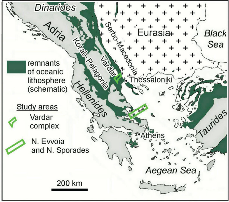
Seismic tomographic images of the mantle below the Hellenides indicate that the Vardar Ocean probably had a composite width of over 3000 km. From surface geology we know that this ocean was initially located between two passive margins: Pelagonian Adria in the west and Serbo-Macedonian-Eurasia in the east. Pelagonia was covered by a carbonate platform that accumulated, during Late Triassic to Early Cretaceous time, where highly diversified carbonate sedimentary environments evolved and reacted to the adjacent, converging Vardar Ocean plate. We conceive that on the east side of the Vardar Ocean, a Cretaceous carbonate platform evolved from the Aptian to the Maastrichtian time in the forearc basin of the Vardar supra-subduction volcanic arc complex. The closure of the Vardar Ocean occurred in one episode of ophiolite obduction and in two episodes of intra-oceanic subduction. 1. During the Middle Jurassic time a 1200-km slab of west Vardar lithosphere subducted beneath the supra-subduction, 'Eohellenic', arc, while a 200-km-wide slab obducted onto Pelagonia between the Callovian and Valanginian times. 2. During the Late Jurassic through to the Cretaceous time a 1700-km-wide slab subducted beneath the evolving east Vardar-zone arc-complex. Pelagonia, the trailing edge of the subducting east-Vardar Ocean slab, crashed and underthrust the Vardar arc complex during the Paleocene time and ultimately crashed with Serbo-Macedonia. Since the late Early Jurassic time, the Hellenides have moved about 3000 km toward the northeast while the Atlantic Ocean spread.

 求助内容:
求助内容: 应助结果提醒方式:


